The researchers from Tel Aviv University, in collaboration with other researchers from Israel, Jordan and the USA, carried out a survey that will help locate the epicenters of historical earthquakes, which were not known until now, and will make it possible to achieve greater accuracy in the forecast * regarding the location of the epicenter in future earthquakes, for the purposes of construction planning * The researchers : We were surprised to see that there are many active fractures that we did not know about until now, and along them a strong earthquake could occur again."

A team of researchers from Tel Aviv University together with other researchers from Israel, the USA and Jordan, carried out a comprehensive survey of fractures created by earthquakes on the sea floor, along the Syrian-African fault and its branches under the waters of the Gulf of Eilat in the territorial waters of Israel and Jordan. The researchers identified the fractures by the displacement of the sediments and fossils - mainly fossilized coral reefs, on both sides of the fracture. The distance traveled by the two parts of the reef made it possible to estimate the activity level of the fault and the intensity of the earthquakes that occurred and their approximate timing.
Prof. Zvi Ben-Abraham and his research student, Gal Hartman, from the Department of Geophysics and Planetary Sciences at the Raymond and Berly Sackler Faculty of Exact Sciences at Tel Aviv University, used various sonar systems to create a detailed map of fault lines created by earthquakes, in collaboration with Dr. Gideon Tibor from the Sea and Lake Research Institute, Dr. Itzik Makovsky from the University of Haifa, Dr. Tina Nyomi from the University of Kansas in the USA as well as researchers from Jordan. The two comprehensive scans, carried out in 2006 and 2010, were done in full coordination with the authorities and the navies of the two countries. A first article detailing the research on the subject, led by Dr. Tibor, was recently published in the journal Geo-Marine Letters.
Prof. Ben Avraham and his team used innovative methods to determine which targeted areas along the fault line are in the greatest danger of damage from future earthquakes. From their research vessel, the researchers operated sonar equipment and examined both the bottom structure and the geological formations beneath the sea floor.
At the bottom of the sea, the researchers discovered canyons and landslides that indicate ancient earthquakes, and together with the new underground information, they can now estimate where and when earthquakes occurred in the past and estimate their intensity. Some of these fault lines were known in the past, but in several cases the researchers discovered branchings and fractures that were not known before and which can shed light on the geological history of the area.

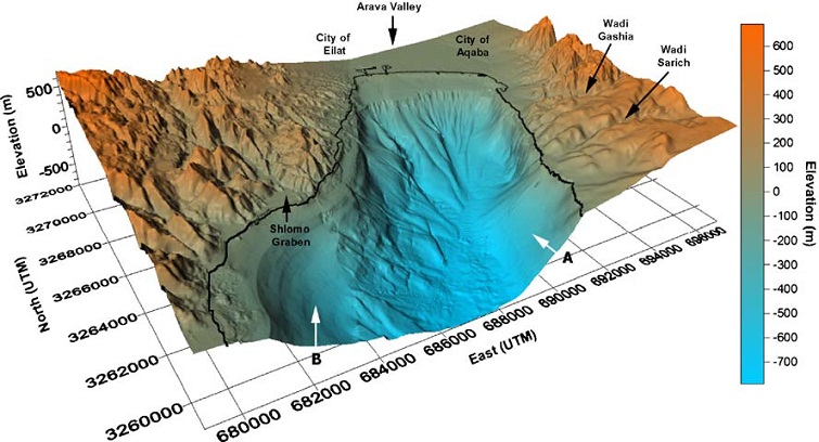
An important research result is a detailed map of the fractures on the bottom of the northern Gulf of Eilat and the identification of the active fault lines. Hartman explains: "When you look from the satellite view, you can clearly see the route of the Syrian-African fault. When you focus the lens and look closely, you suddenly see that the story is much more complex. It is important to identify the active fractures, because if an active fracture passes through a populated area, the risk is great. There are very neat definitions in terms of state regulations as to what is allowed to be built, and what is allowed to be built near active fractures. Each area has a precise definition as to its degree of risk of experiencing earthquakes and the law requires the building planners to prepare accordingly. TMA (national outline plan) 38 (which allows the addition of floors to existing buildings in exchange for strengthening them), should be seriously enforced to prevent damage in the event of a strong earthquake. We were surprised to see that there are many active fractures that we didn't know about until now, and along them a strong earthquake could occur again."
"We cannot say precisely when the next great earthquake will occur, but we can provide the planners of the cities of Eilat and Aqaba with a forecast of possible epicenters and thus give them an opportunity to adjust the construction planning along the faults, and also strengthen the construction in the rest of the areas of these cities in order to allow them to withstand earthquakes in series The size of Otzma Sheva.”
According to him, the importance of planning stood out especially in the events of the earthquake that occurred on March 11 in Japan. "Most of the houses in Japan survived the earthquake thanks to careful construction and proper planning for earthquakes. Geological and engineering assessments with such a destructive tsunami are much more difficult and complex."
In conclusion, Hartman says that the international cooperation also has a value in itself: "The very cooperation between scientists, authorities and navies of the two countries makes it possible to face a scientific research challenge that is relevant to the entire region and not just to one country. Earthquakes do not stop at the border crossings, so the next earthquake could cause damage on both sides and this joint effort is very important."
Photos courtesy of the Tel Aviv University spokeswoman
Caption for photos:
'3D of the seafloor': XNUMXD visualization of the bottom of the northern Gulf of Eilat and the mountainous environment.
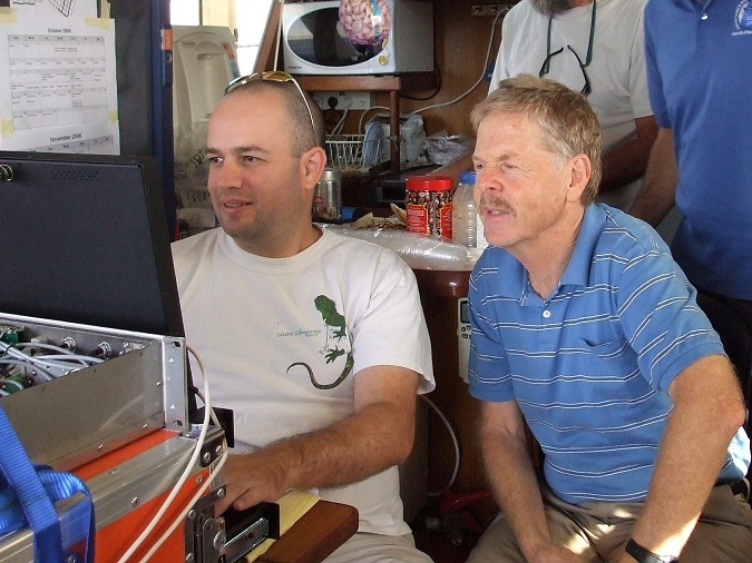
'DSCF3813': Prof. Zvi Ben-Abraham and Gal Hartman during the data collection survey on the research ship Atziona of Sea and Lake Research.
'seafloor': scars on the bottom of the bay explained by active fractures.
--------------------

One response
Hello, I live in Eilat with my family in the Shahmon neighborhood. How do you know which areas in Eilat are at a higher risk? Is there somewhere to drop the information?
Thanks