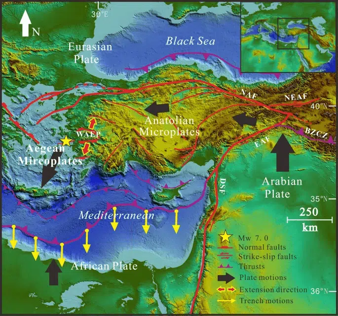
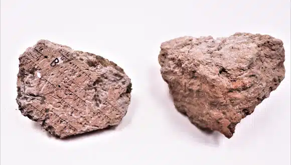
Earth science

The Tova volcano and the lake at its foot. Illustration: depositphotos.com

74 years ago: One of the largest volcanoes on Earth erupted. How did humans survive?

New research shows that the Toba volcano supereruption, despite its power, was probably not the only or main cause of the genetic bottleneck that characterizes the modern human population.
Destruction after an earthquake in Turkey. Illustration: depositphotos.com

Scientists were wrong: Turkey's continental crust is rupturing

Deep beneath Turkey's surface, scientists reveal subtle but powerful movements that are reshaping the continent's crust
The sands of the coastal plain are home to endemic animals and plants – that is, species that are not found anywhere else in the world. Photo: Amir Weinstein, insectour.com Insects – a small world in a big way

Dunes in Danger: Who Will Save the Sand Between the City and the Sea?

Open sandy areas on the coastal plain are shrinking at an alarming rate, and invasive vegetation is changing the landscape. The State of Nature report calls for stopping the change before it's too late
Satellite image of Saudi Arabia. On the left - the Red Sea. Illustration: depositphotos.com

Scientists reveal: The Red Sea completely disappeared 6.2 million years ago

New research from King Abdullah University in Saudi Arabia reveals that the Red Sea dried up and became an arid salt basin, until it was flooded again by a massive flood from the Indian Ocean – an event that changed the geological history of the
The volcanic arc in the southern Aegean Sea. Illustration: depositphotos.com

What's shaking Santorini? Artificial intelligence reveals massive magma movement beneath the Aegean Sea

Scientists have discovered that the earthquake swarm around Santorini was caused by magma rising from great depths - recorded using advanced artificial intelligence and seabed sensors.
Late Permian of the Luangwa Basin, Zambia An artist's impression of a scene from about 252 million years ago, during the Late Permian period, in the Luangwa Basin of Zambia. The scene includes a number of gorgonopsians (saber-toothed predators) and beaked dicynodonts. Credit: Gabriel Ugueto

The Forgotten Creatures Who Ruled Before the “Great Death”

Researchers have uncovered in "Southern Pangaea" (now the southern part of Africa) fossils of creatures that lived shortly before the event known as the "Great Dying," which wiped out about 70% of terrestrial species and an even larger proportion of species
Moai statues stand at the Ahu Tongariki site on Rafa Nui (Easter Island). Credit: Noah Paoa

The iconic moai statues of Rafa Nui (Easter Island) are threatened by rising sea levels

A new study examines how sea level rise has affected the famous statues so far and how many of them will survive an additional rise of several meters given the data on global warming.
Sampling using the ship L'Atalante

"Hitchhiking" microorganisms reflect ocean currents better than free-floating microorganisms

New study finds that microorganisms associated with gastropods reflect ocean currents and environmental conditions better than "free" microorganisms
Carbon deposits in the ocean match the atmospheric composition at the time they were formed. Illustration: depositphotos.com

There were no “syrupy oceans”: Israeli study undermines the myth that “in the past there was much more Carbon – so today is not unusual”

Iron “memory balls” show that the pool of dissolved organic matter in the ocean was small in the Neoproterozoic, and only increased with deep-sea oxygenation and entanglement of food webs – an important correction for the public debate
Photo 1 of a seed fern from the pre-extinct tropical rainforest, Gigantopteris (giant leaves), courtesy of Dr Zhen Xu.

New fossils reveal: Tropical forest collapse caused extreme warming after the Great Extinction

New study finds that the extinction of vegetation during the Permian-Triassic mass extinction limited carbon absorption and led to a long-term increase in temperatures
The effects of the climate crisis on humans. Illustration: depositphotos.com

Earth's climate turns out to be more fragile than expected – new study finds

Researchers present a new measure of carbon load on the climate system and warn: the land, sea, and air began to change as early as the 30s
A rooftop pool empties due to the earthquake felt in Bangkok, Thailand, 28/3/2025. Screenshot, Hindustan Times

Deadly 7.7-magnitude earthquake and 6.4-magnitude aftershock hit Myanmar and Thailand

A deadly 7.7-magnitude earthquake and a 6.4-magnitude aftershock caused widespread destruction in Bangkok, the capital of Thailand, and nearby countries, as well as Myanmar, where the epicenter was.
Small snails and sea urchins come to the boards in droves and destroy everything growing on them. Photo: Maxim Rubin-Blum and Yitzhak Makowsky

Palmachim Disorder: What is hiding hundreds of meters below the surface of the Mediterranean Sea?

Animal habitats have been placed deep in the sea off the coast of Israel. They reveal unique living conditions that have been almost unexplored.
Melting glaciers are slowing the Antarctic Circumpolar Current (ACC), the world's strongest ocean current, researchers have found. Credit: NASA/Goddard Space Flight Center Scientific Visualization Studio

The Great Ocean Slowdown: How Antarctic Ice Loss Is Reshaping the Climate

New research finds that melting ice in Antarctica is weakening the Antarctic Circumpolar Current (ACC) and could lead to worsening climate extremes, disrupting marine ecosystems, and reducing the ocean's ability to absorb carbon by 2050.
The study focuses on the consequences of powerful lightning strikes for infrastructure in contact with the sea. Illustration: depositphotos.com

Lightning Hazard: The Growing Threat to Infrastructure in the Eastern Mediterranean

New study reveals increase in lightning intensity in the Eastern Mediterranean region due to climate crisis and dangers to marine infrastructure and gas rigs
Earthquake damage. Illustration: depositphotos.com

The Hidden Mechanisms Behind Earthquakes: Uncovering the Secrets of the Seismic Process

New research reveals how slow, quiet movements turn into powerful earthquakes, offering insights into fault geometry, friction dynamics, and the ability to predict seismic events
Invisible dust storm. Photo courtesy of the Tel Aviv University spokeswoman

50% of the dust storms in Israel are not recognized and this may endanger the public

In the eastern Mediterranean area there is desert dust in the air almost all year round, and not only in spring or autumn as is commonly thought. Why is this important?
Tectonic map of the faults in the eastern Mediterranean including the Dead Sea Depression and the Anatolian Depression. From Wikipedia

Despite the proximity and direction, the Dead Sea replica and the replica in eastern Turkey are not connected

Researchers at Haifa University and the Geological Institute found that, contrary to the accepted assumption in science to this day, the Dead Sea and Eastern Anatolian areas in Turkey are not tectonically connected, and therefore the strong earthquakes that occurred in Turkey in
The mobile phone can provide data to predict the development of forest fires. Credit: The Science website via DALEE. The image should not be seen as a scientific image

The mobile phones can warn of forest fires and extreme weather conditions

A new study by Tel Aviv University found that the smart cell phones that are in the possession of each of us may help in collecting weather data (from the public) and in providing early warnings about weather conditions
A storm over Acre. Born in Papua, in the province of Papua in Indonesia. Illustration: depositphotos.com

Signals of electric fields can provide early warning of extreme weather

By in-depth examination of low pressure winter systems known as "Cypriot depressions" in the Negev, the study offers new insights into the role of the electric field in the detection of heavy precipitation
The University of Haifa and the GEOMAR Institute are studying the effects of climate change. Photo: Haifa University Spokesperson

Maritime cooperation: The University of Haifa and the GEOMAR Institute study the effects of climate change

The uniqueness of the Eastern Mediterranean comes from being one of the marine areas that reacts the fastest to climate change and human impacts, making it an early warning system for the future state of the oceans
A drone apparently engineers a hurricane and even arranges its clouds in a spiral pattern. The deniers of the climate crisis believe that it is not greenhouse gas emissions that make storms stronger, but the administration that wants Trump to lose the election. The image was prepared using DALEE and is not a scientific image.

Why do people believe in man-made hurricanes? Two conspiracy theorist psychologists explain

As Hurricane Milton battered the coast of Florida, conspiracy theories abounded, claiming that the forces controlling the weather were orchestrating the destruction. The researchers explain why people cling to these beliefs in the face of increasing natural disasters.
Women in Ethiopia carry pots of mud, in the absence of running water. Illustration: depositphotos.com

Getting even hotter and no one cares about third world residents

The climate crisis is already here. For the residents of the poor countries considered the "Third World", there is no doubt the culprits: the rich Western countries. Not only do they avoid actions to prevent warming, they also continue to develop sources of pollution
Two pairs of introductory divers and their guide surround the artificial reef Photo: Dr. Jenny Tiniakov

Artificial reefs protect the coral reefs in Eilat

Researchers from Ben Gurion University followed divers in Eilat for 15 years and found that the placement of the artificial reef reduced the pressure of diving on the natural reef
A study predicts the extension of the Strait of Gibraltar subduction zone into the Atlantic Ocean, which could create an Atlantic Ring of Fire within about 20 million years. This research sheds light on the dynamic nature of ocean life cycles and the formation of new reduction zones, using advanced computational models. It offers new insights into the activity of the subduction zone in Gibraltar and its implications for seismic activity, emphasizing the importance of preparedness and studying the process of ocean contraction as a key process in the geological evolution of the Earth. Credit: Mr Elliot Lim, CIRES &NOAA/NCEI

As the oceans close - new research indicates that the Atlantic Ocean will "soon" enter its sunset phase

Research shows for the first time how direct invasion of mitigation zones can occur. The 3D computational model, driven by gravity, predicts that the subduction zone currently under the Strait of Gibraltar will spread further
Almog Beach, Eilat. Illustration: depositphotos.com

Between sky and water

How growth of the mineral calcium carbonate affects the carbon dioxide cycle in the waters of the Bay of Eilat, and thus the ecosystem and climate warming
Mediterranean. Illustration: depositphotos.com

A historical window to the Mediterranean Sea

Following the drying up of the Mediterranean Sea about five million years ago, valleys developed in its southeast that are about eight kilometers wide and about 1,000 meters deep
A robotic government official. Illustration: depositphotos.com

The Ministry of Innovation and the BARD Foundation will support Israeli-American R&D in the field of food security

In addition, the Ministerial Committee for Science and Technology approved: the formulation of a national plan to promote the Blue-Tech field in Israel
Feather clouds. Illustration: depositphotos.com

The connection between lightning storms and cirrus clouds

An increase in the number of lightning storms may increase the amount of cirrus clouds and increase the global warming process
Epicenter in Morocco, September 8, 2023. Source: US Geological Survey USDS

The earthquake in Morocco: since the 19th century, strong earthquakes of magnitude 6 or higher have not been recorded in the area

Earthquakes of this magnitude in the region are rare but not unexpected. Since 1900, there have been 9 earthquakes of magnitude 5 or higher within 500 km of the location of the current earthquake, but even
A clean tropical beach without "development". Illustration: depositphotos.com

The beaches can serve as a natural buffer between the sea and the depth of the land, if man removes his intervention

An initiative is needed to save the beaches that are damaged due to human activity combined with global warming.

Israel, the United States, Germany and Tanzania are collaborating to create clean drinking water

Cooperation between non-profit organizations and government institutions from Israel, the USA, Germany and Tanzania with the aim of building an innovative water filtration system using ceramic filters at a school in Babati district reached its peak when a delegation of engineers without
Map of lakes and rivers in Africa. Illustration: depositphotos.com

Struggles over rivers

Following and because of global warming, by 2050 there will be about a billion people subject to disputes and struggles related to rivers, and this only in Africa
The children of the Maasai tribe herd the cattle. Illustration: depositphotos.com

move with the climate

The children of the Maasai tribe herd the cattle Illustration: depositphotos.com
Initial photograph of the flooding in the Ukrainian territory as a result of the explosion of the dam by Russia. Photo: Website of the President of Ukraine

The war in Ukraine: what we know about the Nova Khakhovka dam and who benefits from its demolition

The destruction of the Nova Kakhovka dam came just as it seemed that Ukraine's counterattack was about to begin. It's probably not a coincidence. The operation was designed to engage the Ukrainian army in evacuating residents and block the
A band of clouds in the equatorial region that is created due to the rise of air in the Hadley cell and is responsible for the strong precipitation in this region

Winds of climate change

For two decades, researchers have been trying to find a way to track a climate system that has a decisive influence on the location of rainforests and deserts on Earth. A new study solves the challenge and reveals the extent of the impact
The plastic that reaches the bottom remains available to the animals in the sea. Photo by PublicDomainPictures on Pixabay

When the seabed is covered with plastic

Plastic continues to dominate every good plot: new research reveals that the amount of microscopic plastic on the ocean floor has tripled in just 20 years. Moreover, the microplastic at the bottom of the sea almost did not disintegrate
Ocean Based's Salvador Garcia (left) explains to Gian Paolo Bassi, senior vice president, 3DEXPERIENCE WORKS about the system the company is building to enrich sea life to absorb carbon at the 3Dexperience Word 2023 conference in Nashville. Photo: Avi Blizovsky

Bloom the marine wilderness and absorb carbon from the atmosphere

The American company Ocean-Based Climate Solutions has developed a pump system that will pump nutrients from a depth of 400 meters to the surface and allow the growth of tiny algae that will perform the photosynthesis process and absorb the carbon
The movement of three tectonic plates "acting in opposite directions causes frequent seismic activity in this region. Meng, J., Sinofelo, A., Zhou, Z., et al. Greece and Turkey shaken by African tectonic retreat. Sci Rep 11, 6486 (2021). https://doi.org/10.1038/s41598-021-86063-y, CC BY-NC

The earthquakes in Turkey and Syria were deadly because they occurred close to the ground

Two strong earthquakes within a few hours and the fact that there was no thick layer of soil that reduces the intensity of earthquakes, in addition to the construction conditions, and the destruction of the infrastructure - especially in Syria. Also for the time of the earthquake 4:17
Prof. Martinus Theodore "Rin" van Gnochten, Federal University of Rio de Janeiro, Brazil

Martinus Theodor 'Rin' van Gnochten is the winner of the Wolf Prize for Agriculture

He studied the movement of water in the unsaturated medium between the soil and the groundwater. This layer is important for agriculture, pollutant transport and flood control
A swarm of bees returns to the hive. The researchers found that the bees created an electric field in the range of 1,000-100 volts per meter. Illustration: depositphotos.com

Is there electricity in the air? These are the bees

The power of a group - the electrifying version: British researchers discovered that swarms of bees carry a particularly powerful electrical charge. It turns out that the buzz is literal
A system of shopping malls in Nahal Peretz. Photo: Matanya Hamaoui

The collapse of caves created an impressive system of canyons in the Dead Sea region

The desert landscape brings with it an extensive field of research. This time, a research group from Ben-Gurion University of the Negev and the Geological Institute analyzed the shape of the landscape in the popular hiking area and pointed to the model for the development of Nahal Peretzim in its shape
African Zved. Illustration: depositphotos.com

What about the anointing of kings and the exploitation of nature, p

The African Zabads are caught in a bar to extract the musk oil that has been used since ancient times to anoint kings. Is it possible to develop a more humane method?
One of the rainwater collection systems built by the team in April 2022. Photo: Engineers Without Borders team - Israel Tel Aviv

Water and education in Tanzania against the background of one of the worst droughts the country has ever known

A project carried out by members of the Africa team of Engineers Without Borders Israel - Tel Aviv contributes to the supply of clean drinking water to rural areas in Africa, and has been operating continuously since 2013 in the Babati district of northern Tanzania.