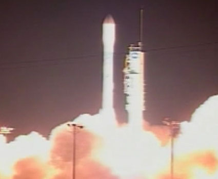
The launch was carried out from the Vandenberg Air Force base in California at 10:46 this morning (Israel time). The satellite will continue the operation of two previous satellites and will monitor the sea level in different areas across the oceans to monitor global warming

The OSTM/Jason-2 satellite was launched this morning at 10:46 (00:46 local time) into orbit on a United Launch Alliance Delta 2 rocket from Vandenberg Air Force Base in California.
"We see the spacecraft gently moving away from it," telemetry manager Mark Loveing reported, and a video sent from the launcher showed the separation of the second stage.
Jason 2 will orbit the Earth in a low-altitude circular orbit, on a three-year mission to map the 95% surface of the oceans that is not covered by ice. The information that will be collected from the satellite weighing about 500 km is expected to provide several benefits, including improving the weather forecast, greater accuracy in hurricane forecasts and a better understanding of climatic phenomena related to the sea such as El Nino and La Niña.
Additionally, As we detailed in the preliminary article yesterday, the satellite will constantly monitor the sea level and thereby continue the work of two previous satellites. The sea level is rising, among other things, as a result of global warming.

4 תגובות
oak:
There is a certain contradiction hidden in your words because the sea level depends on the temperature.
The law of combined tools works. Although not immediately (because it requires the flow of water from one place to another) but what this law says (in global standards) is not that the level of the water surface will equalize but that the hydrostatic pressure will balance.
It sounds strange that in order to measure the change in sea level, such an expensive system is needed. The combined instruments law does not (yet) stand up to the test and in my understanding the rise of the sea level is not specific.
Measuring the sea temperatures is another story
Lalon
Apparently one float is not enough. In order to get an overall picture of the state of the seas, around Kadaha, you need thousands of buoys.
Go out and calculate what work is needed for maintenance and regular measurement of results in thousands of measurement points in the sea. It is probably cheaper and more accurate to list.
Can someone explain why an expensive satellite is needed to measure sea level?
Not enough buoy?