The aerial platform known as pseudo-satellites, or HAPS is designed to operate at an altitude of 20 km - too high for planes but too low for satellites and to be used to complete communications and photography coverage
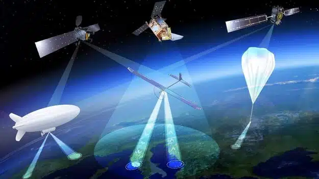
The European Space Agency is considering expanding its activities to a new area of the sky using a new type of aircraft, which will serve as the "missing link" between drones and satellites.
High-altitude pseudo-satellites, or HAPS (High-altitude pseudo satellites), are platforms that float or fly at a higher altitude than conventional aircraft, but operate more like satellites - except that instead of working from space, they can stay inside the atmosphere for weeks or even months, and cover an area.
The European Space Agency states that the best working height is about 20 km, where the drone or pseudo-satellite will be above the clouds and jet stream winds, and 10 km above the commercial aircraft routes. At this altitude, the wind speeds are low enough for the vessel to last there for long periods. From such a height, they can survey the ground up to the horizon at a distance of 500 km, in a way that enables precise monitoring and tracking, high bandwidth communication, or backup for existing satellite navigation services.
Several European Space Agency teams teamed up to explore the potential of pseudo-satellites. Future systems expert Antonio Cioculcala: "For Earth observation, they can provide long-term high-resolution coverage in priority areas - for example, areas affected by a natural disaster, while for navigation and communication, they can close blind spots in coverage and combine wide bandwidth with negligible signal delay."
"The European Space Agency is investigating how these different areas can be connected in the best way."
Earth observation expert Thorsten Fehr explains, "We've been looking at this idea for twenty years, but only now is it finally becoming a reality. This can be attributed to the maturation of key technologies: miniaturization of avionics systems, high-performance solar cells, lightweight batteries, miniaturization of Earth observation sensors and broadband communications that can provide services at a competitive price.”
Navigation engineer Roberto Prieto Serdeira adds that "there is a clear potential for providing a quick response in emergency situations, and these tools can also be used to cover satellite navigation for dense cities with narrow streets as well as mountainous areas."
European companies have already unveiled product lines. For example, Airbus developed what it called the Winged Zaphyr, a solar-powered drone that already in 2010 achieved a world record 14 days of continuous flight without refueling. In its latest version, the Zephyr-S will be able to fly loads weighing several tens of kilograms for up to three months at a time, with secondary batteries that will allow it to be operated even at night. The company plans to develop a larger version that will feature a Zephyr-T that will allow the tool to carry a higher weight and also greater electrical power.
Thales Alenia Space, meanwhile, is preparing the Stratobus, an airship that can carry cargo weighing up to 250 kg. Its electric motors fly against the wind to stabilize itself. It also runs on fuel cells at night. The first flight of the Stratovos is expected in 2021.

2 תגובות
Conan
The GPS satellites are in constant motion, and their speed is high - they circle the earth every 12 hours. There are ground stations that send their location to satellites, and they transmit this data to the GPS receivers.
At an altitude of 20 km there are indeed winds, but they are usually weak, and fortunately, they are fairly predictable. The accuracy required for the location of these tools is not high (in the case that I know - an accuracy of up to 2 km for half of the time, and 150 km for 95% of the time). The balloon's engines are designed to provide sufficient thrust from solar energy to winds for most days of the year.
The approach to solving the problem is: 1) determining the required accuracy, and 2) measuring the winds that exist in that area and 3) determining the energy regime to maintain the required accuracy in the existing wind conditions.
The position of each of the satellites used for GPS systems is known and updated immediately whenever there is a change in its position greater than several microns (=millionths of a meter). On the other hand, at a height of only 20 km above the surface of the earth there is still an atmosphere and strong winds that will move these pseudo-satellites to greater distances in short periods of time (we all know that a gust of wind is enough to easily move a balloon - what will happen to a satellite balloon when it is surrounded by winds at a speed of hundreds of kilometers per hour?). Therefore, any such pseudo-satellite will be constantly forced to run engines in order to return to the position where it is supposed to be - that is, in order to stay for several hours in the original orbit, there will be fuel consumption in really crazy values!) - How do you even approach the solution of such a problem?!?