The information received from satellites is used for many purposes, from espionage to the transmission of television broadcasts. Israeli researchers develop an innovative method in which they use satellite images to know the effects of animal grazing in large areas October 24, 2015
Dr. Miri Tzlock, Angle - Science and Environment News Agency
do you like steaks do you like cheese Are you devout vegans who want to save the planet? Whatever the answer, what is important is that rangelands have a major impact on the lives of all of us. The pastures are essential not only because they provide meat and milk, but also are open areas for recreation and leisure, protect the soil, purify water and preserve the habitats of a rich variety of species. On top of that, these areas store about 20 percent of all the carbon in the world and thus help to moderate global warming.
Despite their importance, many rangelands around the world are being destroyed by accelerated development, climate change and overgrazing. These changes can cause damage to the soil and desertification, a dangerous phenomenon spreading across all continents. On the other hand, in Israel there is sometimes the opposite problem of lack of grazing, which increases the risk of fires spreading. An innovative study presents the development of a method for monitoring the changes occurring in pastures using NASA satellite information.
How is grazing effect measured?
Because of the dangers facing grazing areas, it is more important than ever to measure the impact of grazing on them. How do you measure it in areas that cover almost half of the Earth's land area? Worldwide, field methods have been developed to measure the amount of plant material (biomass). The problem with these methods is that ground monitoring requires a lot of time, manpower and resources and does not provide good spatial coverage.
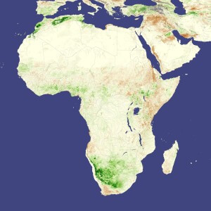
Drought in Africa in 2006: areas with abundant vegetation are shown in green, areas with less healthy and thriving vegetation are brown. Photo: NASA image created by Jesse Allen, using data provided courtesy of Jennifer Small, NASA GIMMS Group at Goddard Space Flight Center
Drought in Africa in 2006: areas with abundant vegetation are shown in green, areas with less healthy and thriving vegetation are brown. Photo:
NASA image created by Jesse Allen, using data provided courtesy of Jennifer Small, NASA GIMMS Group at Goddard Space Flight Center
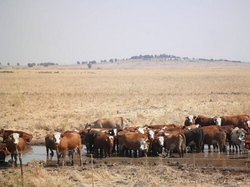
The new research was carried out in a unique pasture in California, owned by a leading international nature conservation association, the TNC (The Nature Conservancy). The research area is of double importance because it is intended both to maintain a variety of unique animals and plants and also to provide economic value for cattle breeding.
The measure of the intensity of grazing and the values of nature in the area is the amount of grass in the fall at the end of the grazing season, so it is monitored every year. The aim of the study was to develop a fast and accurate method for measuring the amount of grass in order to reduce the high costs that the association devotes to monitoring.
NASA satellites in the service of the community
The innovative method monitors the effect of grazing in large areas using the MODIS (Moderate Resolution Imaging Spectroradiometer) satellite simulations. It is a satellite of NASA, the American space agency, which photographs the entire planet every day. Satellite has a huge advantage in that it provides information available to the general public for free, easily and quickly.
The information in the MODIS simulations is types of plants that use different wavelengths of light, and calculation of these indices is a figure that allows measuring the amount and coverage of plant material. The researchers discovered that the vegetation indices measured from the satellite accurately track the timing and amount of rainfall that fell a few days earlier. In the last decade, for example, there was a clear connection between the amount of grass measured by ground monitoring and three satellite dimensions. This example shows the precision enabled by the satellite in measuring the amount of vegetation and its sensitivity to changing climate conditions.
What is more interesting is that the amounts of vegetation that the satellite measured in the spring, at the peak of the grass growth season, can predict the amount of grass that will remain at the end of the grazing season in the fall. This finding is of crucial importance in the management of grazing areas: the managers of the areas can view the satellite values for free and in a simple way every spring, and thus know how much cattle can be put in the area and for how long. In fertile years, it is possible to allow greater grazing pressure and generate a greater profit from the area, while in drier years it is possible to anticipate this and prevent overgrazing.
The innovative method will be used for enforcement that will prevent overgrazing. Instead of monitoring the condition of the land on the ground every year, the TNC Association will use the satellite information to make sure that the intensity of grazing that year did not exceed the permitted threshold. Thanks to the efficiency and accuracy of the method, the association decided to adopt it for the annual monitoring of all tens of thousands of dunams of the grazing areas under their management. This saves many resources for the sake of preserving nature.
Even though the method was developed to measure the amount of grass, it also works well in the Betha and Mediterranean forest areas, and it is possible to apply it in Israel as well, thus promoting the benefits of grazing for the management of open spaces in the country.
Satellite information for nature conservation
The MODIS satellite is of immense value for research and monitoring processes on Earth. The satellite has many applications for natural resource management, planning, enforcement and setting environmental policies. Worldwide it is of crucial importance in monitoring development, changes in land use and mapping ecosystems. For example, in Brazil the authorities use it to monitor illegal deforestation and they managed to reduce crime by 70 percent.
Nature reserves use simulations to manage fires, while nature conservation organizations use information to plan important areas to protect endangered species. In Israel, the use of satellite information for environmental management is still in its infancy, but environmental bodies use MODIS and other satellites for vegetation mapping, forest area management and precision agriculture. At the annual science and environment conference of the Israeli Association for Ecology and Environmental Sciences, a special session was held on the applications of remote sensing for natural resource management, in an attempt to promote the use of satellites also in the Ministry of Environmental Protection.
The full study was presented at the annual conference of the Society for Ecology and Environmental Sciences, October 2015.
More of the topic in Hayadan:
