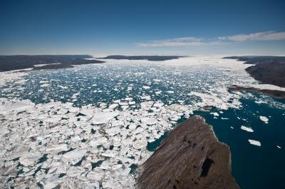
A new international study provides solid evidence of the state of the continental ice sheets and their contribution to sea level rise.

The two largest glaciers have been losing ice rapidly in the past decade, causing great concern.
A new international study provides solid evidence of the state of the continental ice sheets and their contribution to sea level rise.
Dozens of climate scientists have combined their data on the changes in ice cover in Antarctica and Greenland over the past two decades. The findings published last Thursday, November 29 in the journal Science, reduce the uncertainty by half and discard contradictory observations.
"We are just getting started with a record-breaking observation of the ice," says Evin Joughin, a glacier researcher at the Applied Physics Laboratory at the University of Washington, who led the review article that accompanied the study. "The findings create a long-term data series whose importance will increase as new measurements are added."
The article reviews three methods used by different groups at the same place and time, which allowed the researchers to discard some of the extreme observations and show that the findings agree with each other within the uncertainty limits of the methods.
"The unified method provides a simpler picture," says another research partner, Benjamin Smith, also from the University of Washington's Applied Physics Laboratory. In the nineties, not too much happened, sometime around 1999, the ice blocks began to lose mass and most likely the rate of mass loss has increased since then."
The research effort, led by Andrew Shepherd from the University of Leeds in the UK, compromises between three ways to measure ice loss. The first approach is the accounting approach that combines climate models and observations to estimate the addition or loss of ice. The other two approaches use satellite imagery to accurately measure the height of glaciers and the gravitational pull of the ice caps to estimate how much ice they contain. Each approach has strengths and weaknesses. So far the scientists using each have published separate estimates from the others. This is the first time that a comparison of the methods was made for the same places at the same time. "The new approach connected all the methods" said Jonghin. "Now you can compare apples to apples."
Since 1998, one of the hottest years in history, researchers have published at least 29 different estimates on the contribution of the continental ice sheets to sea level rise - from 1.9 millimeters to 0.2 millimeters per year. The integrated assessment holds that since 1992 the melting glaciers have contributed an average of 0.59 millimeters to sea level each year, with an uncertainty of 0.2 millimeters per year. In total, the sea level has risen by about a third of a centimeter (3.3 millimeters) in the last twenty years, but this is mainly due to the expansion of water in the warm areas of the oceans as a direct result of the warming, regardless of the amount of water.
"Creating a consistent assessment system for the ice contribution should reduce confusion, both in the scientific community and among the general public." Joughin said.
Understanding why the ice sheets are rapidly losing mass in the last decade is the subject of extensive research. The rapid ice loss was not predicted by the models, leading the IPCC not to set an upper limit for future ice loss.
Joughin is the author of a companion paper that reviews the factors that cause continental glaciers to lose mass. In particular, he studies what happens when warm ocean water reaches the side of the Antarctic ice sheet or next to glaciers in the fjords of Greenland.
Joughin and his colleagues suggest ways to better monitor and understand the changes: creating a finer ocean model that can also include narrow fjords and develop additional models to study the interaction between glaciers and ocean water, and improve the monitoring of large land ice covers.
Even a small rise in sea level, multiplied by the area of the oceans, could increase storms and flood coastal areas and islands. The West Antarctic ice sheet could drive global changes if it becomes unstable, and Greenland's ice, which is thought to be more stable, could also cause problems there.
"We don't know the reason for the acceleration in ice loss," said Joughin, "but the more long-term observations we have, the better predictions we can make."

5 תגובות
You should update the article.
On the contrary. The latest data from the US government show a huge increase in the Arctic ice sheet, and likewise in Antarctica.
Ilana
There is a lot to do. Some people also do a lot.
If everyone contributes something then the situation can improve.
The peninsula that creates a headland towards South America, since South America is a western continent, that's what its 'continuation' in Antarctica is also called
How does Antarctica have a west?
Thanks for the information. The dynamics of the changes as a result of global warming puts the human race in a state of helplessness. Because what else can be done. At least be aware..