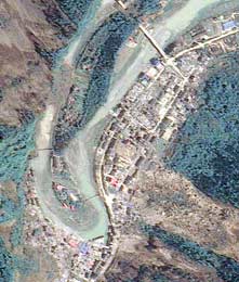
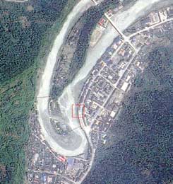
Ironically, the photos taken by a Taiwanese satellite will be used to locate survivors as well as assess the damage. The pictures also show huge mudslides

In recent days, satellite images of the area in China that was hit by a 7.9 magnitude earthquake on May 12, 2008 have been published. The images show Beichuan, one of the hardest hit areas in Sichuan province in southwest China. The images reveal a large forest, a school and a group of residential houses along the river that were destroyed by the earthquake. A road along the river was also badly damaged. The images were taken from the Taiwanese satellite FORMOSAT-2. The same satellite photographed the area about two years ago - in May 2006 and this photo is also available.
The photos will be used by China for an attempt to locate and rescue survivors who are still missing in Sichuan.
Harry Chang, a professor at National Taiwan University, said the photos were handed over to the Chinese Academy of Sciences, despite the rivalry between the two countries. Chang said that in Beichuan, the earthquake also caused landslides, such as those seen in the photo, covering an area of 14,800 dunams and blocking the river.

As a result, new lakes were also created. What is dangerous is that when these lakes erupt, the residents who live in the lower areas may be in trouble." said.
Chang also warned of mudslides in the coming rains, he said. "They will make the rescue work much more difficult," he said. As of May 15, it is estimated that the number of casualties may reach 50 thousand.
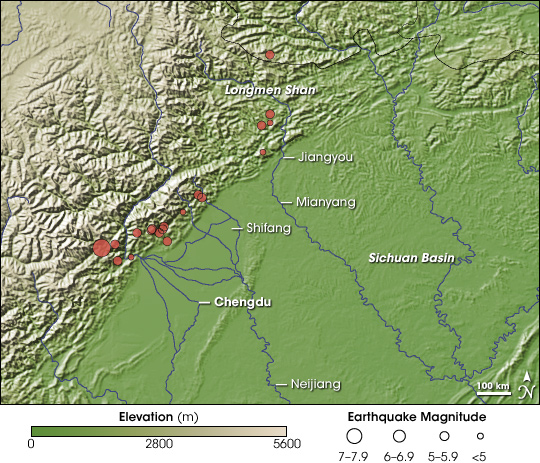
The earthquake began at 14:28 local time (09:28 Israel time) and was felt in most areas of China as well as in parts of Taiwan, Thailand and Vietnam. The elevation map shows the areas where the earthquake hit. The green color represents low areas, and beige is the highest. The data for the map was collected in 2000 from topographic radar mapping from one of the space shuttles. The location of the main earthquake whose epicenter was 90 kilometers west-northwest of the city of Chengdu was also placed on this map. Lower intensity events occurred northeast of the center of the head and more or less followed the lip of the Lugman Shan mountain range.

As you may recall, the earthquake in China occurred not long after the cyclone in Burma, which claimed the lives of 130 people, as of this moment, and many more are in danger due to the government's incomprehensible lack of response to international aid efforts. As we mentioned a few days ago, the Burma region was also photographed from space and the dimensions of the cyclone damage are evident.

2 תגובות
Note - this is a reference to the site that glorifies and praises Islam and seeks to show that it has scientific proof. This referral was placed by an anonymous writer from an IP that targets a company in the Netherlands that is used as a bypass. Therefore, this should be considered spam and the messages whose content other than the link was "enter is very important" should be removed. Apparently someone made a CUT AND PASTE for a typical response on YNET....
Livnat, one more link and the first one left will be deleted.
First, irrelevant links to the news constitute spam, and secondly - all religions are treated equally here.