A satellite sensor that can see in the dark reveals new information to meteorologists, firefighters, rescue teams and researchers around the world
No one likes to be in the dark about what is happening around them, and this is doubly true in times of danger. And here, when the darkness of the night suddenly takes over land or ocean, scientists and forecasters stop receiving satellite images in the visible light range and thus lose information about whirling storms, about suffocating smoke billowing from fires, about large sea glaciers that endanger ships, and about other and more terrible clouds.
A new sensor, called "Day Night Band", begins to fill this void. The sensor, which is part of the visible and infrared imaging system known as VIIRS carried on the Suomi-NPP satellite, is so sensitive that it can measure the glow of a single street lamp, the deck lights of a single ship in the heart of the coal-black Atlantic Ocean at night, or the The roar of a gas flame flickers across the vast expanses of North Dakota's oil fields. Even on moonless nights, the sensor can spot clouds or snow-covered fields illuminated by the faint nightglow of the atmosphere itself.
Researchers using the sensor have over the past three years observed fascinating features of the forces acting on Earth, such as massive energy waves launched by thunderstorms high into the atmosphere. Data from the sensor has also improved forecasters' ability to warn residents living in the path of hurricanes, helped firefighters track the movement of deadly smoke clouds, and helped errant ships avoid ice floes floating in the ocean.
The sensor also provides complementary information to that coming from other infrared light sensors because the other sensors have difficulty detecting low cloud cover and snow cover, which tend to blend into their surroundings in the dark. Besides that, scientists have already started feeding the data coming from the "day-night strip" sensor into the software that calculates how much moonlight there is on a certain night. From this information it is possible to determine the degree of light reflection of clouds and hence to deduce the amount of moisture stored in them. Forecasters can use this information to predict how cloudiness will affect ground-level temperatures overnight, and also to help pilots avoid weather conditions where ice can build up on their planes. The data from the sensor can also help with daily weather forecasts intended for communities located in very northern or southern latitudes, which are immersed every winter for many months in complete darkness without essential information about the weather conditions around them.
Currently, only one "day-night band" sensor is operating in space. The Suomi-NPP satellite, operated by the US National Oceanic and Atmospheric Administration (NOAA), orbits the Earth in an orbit that is 800 km high and is synchronized to the movement of the Sun. As a result, it passes over any given point on Earth twice a day: at approximately one-thirty in the afternoon and one-thirty at night, according to local time. If such sensors were installed in geostationary satellites, so that each sensor would constantly hover over one point on Earth, it would be possible to record continuous movies of light sources and not just single images.
A possible platform for such continuous night vision is a future series of geostationary environmental satellites, known as GOES, that NOAA plans to launch in the 30s. If these satellites carry sensors similar to the "day-night band" sensor, researchers will be able to continuously monitor light sources at sea and on land and thus monitor clouds, rain, oil slicks, fires, smoke, dust storms, volcanoes and ice blocks throughout the night. They will also be able to track down fishing vessels that sail illegally in no-fishing areas and help locate planes that have crashed at sea, as recently happened to the planes of Malaysia Airlines, Air Algiers and AirAsia.
Rescue at sea
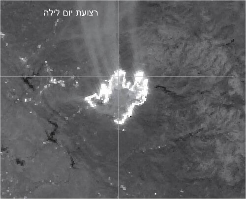
The American fishing vessel Kiska Sea, which for a certain period of time starred in the popular TV series "Deadliest Catch", is part of a fleet of crab shoals in the Bering Sea. In February 2014, strong northerly winds blew in the middle of the Bering Sea that pushed ice blocks into the area where the crab shoals set traps the size of a double bed. On February 10, when the Kiska Sea was the northernmost vessel in the fleet, the ship's crew called the U.S. Weather Service's floating ice monitoring station in Anchorage, Alaska, and requested information about the condition of the icebergs near the line of traps the ship had deployed.
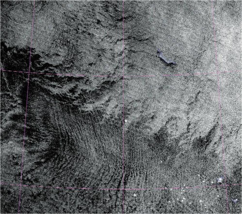
The members of the meteorological service confirmed that indeed the ice blocks are penetrating the area of the traps. The Kiska C moves toward the traps to collect, maintaining continuous contact with the Anchorage monitoring station. But on February 13, the Kiska Sea crew found themselves surrounded by floating icebergs, some of them more than a meter thick. To avoid capsizing or being crushed, the Kiska C had to move fast, but the short day and moonless night made navigation dangerous. The tracking station used the data from the "day and night strip" sensor to detect the ship's lights and locate its position with great accuracy (a white dot in the center of the image on the right; you can see other ships in the lower right corner). The sensor also took advantage of the dim night glow of the atmosphere to outline the ice front line (broken lines pointing down from the upper right corner).
With this detailed information, the meteorological service team helped the captain steer the ship in a west-southwest direction, out of the blockade of the floating ice blocks. Earth's atmospheric "night lights" thus helped lead Kisaka Sea back to safe waters.
The Hurricane Hunter
When a hurricane occurs, it is essential to know the location of the eye of the storm because the strongest winds and strongest storm surges occur just outside of it. More accurate tracking of the storm's eye can save lives, influence emergency managers' decisions about civilian evacuations, and save millions of dollars by more precisely positioning rescuers and improving the allocation of resources.
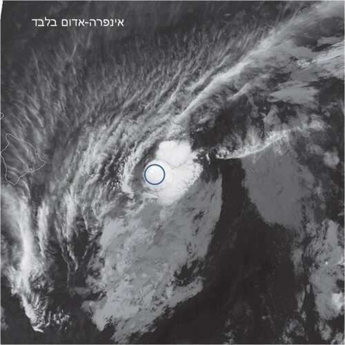
On July 28, 2013, Hurricane Pelosi threatened the Big Island of Hawaii. Weather forecasters closely tracked the location of the storm, but after nightfall lost track of the eye of the storm. High cirrus clouds hid the eye of the storm located at lower altitudes from the usual infrared sensors in the satellites (black and white image). As the night progressed, the forecasters felt more and more disturbed by the possibility of a "sunrise surprise": a situation where they think they are accurately following the hurricane's nighttime path but only at sunrise discover that due to changes in winds at high altitude, which cause deviations in the path of hurricanes, the eye of the storm is not found Under the thickest layer of clouds as they thought.
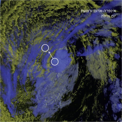
This time, fortunately, the satellite carrying the "day-night band" sensor passed over the storm in the hours before dawn. The sensor easily penetrated through the thin clouds in the upper layers (blue in the color photo) and detected the eye of the storm at ground level (yellow). The images showed that the center of the storm was further north than expected (moving in the northwest direction of the blue circle), so the threat to the island was lower than previously estimated. The forecasters at the Honolulu branch of the American Meteorological Service issued a forecast at 5 am in which they informed the emergency forces of the change in the storm's path and thus prevented the unnecessary evacuation of citizens and saved thousands of dollars.
Peek through the smoke screen
The number of wildfires in the western United States is on the rise, in part because of perennial forms. Because it is difficult to track smoke or fire fronts hidden by smoke in the dark, firefighters who battle these violent fires during the day often find that the fires take advantage of the night to make progress.
Wildfires can also create strong winds that change the speed and direction of the flames, which can suddenly endanger fire crews. Smoke cools quickly and its temperature equals that of the air around it. At night, smoke clouds thus become almost invisible to infrared sensors on satellites. These sensors also often fail to detect small flares along fire fronts.
Not being able to fight flames during the night is a frustrating problem because it is during these hours that the temperatures are lower, the humidity is higher and the winds are weaker, so the night is the perfect time for extinguishing operations. Sensors that are sensitive to low light can help, as can be seen in images from a large wildfire that occurred in California in 2013 (above). First, when there is moonlight, such sensors can often see clouds of smoke clearly and provide a warning to firefighters (top right), unlike infrared sensors that do not see this smoke (top left). Second, the sensors can more precisely determine the location of fire fronts, including small flare-ups (you can see that the image above on the right is more detailed). The smoke clouds also provide valuable information about the near-surface winds that blow air into the flames. The top right image shows strong southerly winds carrying the smoke north. In this case, the right step for the firefighters was to approach the flames from the south.
The night glow of the atmosphere
If you stretch your hand up, even on a dark night without moonlight and when you are far from any light source, you will still be able to see her blurred silhouette against the background of the "black" sky. This is because complicated chemical reactions in the upper atmosphere emit dim light. Astronauts on the International Space Station regularly record this nocturnal glow, but its detailed structure was unknown until now. Researchers using a "day-night band" sensor were amazed to discover that features of auroras appeared one night in the vicinity of a thunderstorm. The images showed characteristic ripples in the night glow. Energy released during a thunderstorm sends atmospheric waves that travel upward. About an hour to two hours later, when these waves reach a height of almost a hundred kilometers, i.e. close to the edge of the mesosphere, they shake the night glow layer and create glowing ripple circles with a common center. The sensor captured this phenomenon during a powerful thunderstorm in Texas in 2014 (above) and other events.
These waves are more than a curiosity; They carry energy that drives the swirling air currents in the upper atmosphere. The ability of the "day-night band" sensor to detect these waves and ripples fills a gap in the models that describe the dynamics of the upper atmosphere and thus helps researchers better predict the weather and understand climatic changes. Observations made from the ground have linked waves of auroras to strong earthquakes, including the earthquake that created the devastating 2011 tsunami near Tohoku in Japan. The seismic movements appear to create pressure waves that move upward in the atmosphere. It is possible that with the help of the "day-night band" sensor, scientists will be able to detect tsunami waves even as they cross the ocean by following the atmospheric waves moving above them.
in brief
- A new satellite sensor, known as the "day-night band", can detect light sources on Earth that are many times weaker than what older sensors can detect.
- This sensor can also detect clouds, snow and other features that disappear on moonless nights and are illuminated only by the atmospheric glow.
- Data from the sensor helps researchers track objects that are almost invisible at night, such as hurricanes, wildfire smoke and stray ships.
- The addition of similar sensors to geostationary satellites will provide movies of the light sources on Earth over 24 hours rather than single images taken twice a day.
About the author
Steven D. Miller is a senior researcher at Colorado State University's Cooperative Institute for Atmospheric Research. He is responsible for many of the images in this article.
