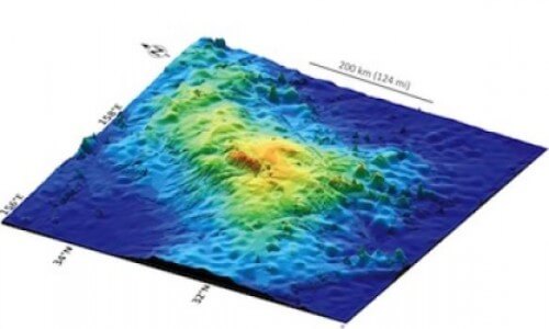
The extinct Tamo Massif volcano, which is 4 km above the ground and its summit is 2.2 km below the surface of the Pacific Ocean, was created in a single eruption and is not a chain of mountains as thought until now. It occupies an area similar to that of the British Isles

A team led by researchers from the University of Houston discovered the largest single volcano recorded on Earth. It covers an area equal to the British Isles. The mountain, known as the Tamu Massif, is almost as large as the largest volcanoes on Mars, classifying it as one of the largest in the solar system.
Prof. William Sager, from the Department of Earth and Atmospheric Sciences at the University of Houston began researching this volcano 20 years ago at the A&M College of Earth Sciences. The research of Sager and his staff will be published on September 8 in the journal Nature Geoscience - a multidisciplinary publication in the fields of earth sciences.
The Tamo Massif volcano, located about 1,500 km east of Japan, is the largest mountain in the Shatsky Rise, an underground mountain chain that was formed 130-145 million years ago by the eruption of several submarine volcanoes. Until now, it was not clear whether Tamu Massif is a single volcano or is composed of many eruption points. Using a combination of data collected by the JOIDES research vessel, the researchers confirmed that the basaltic mass that makes up Tamu Massif did erupt from a single source near its center.
"Tamo Massif is the largest single volcano discovered on Earth," says Sager. "There may be other larger volcanoes because there are other formations of this type such as the Ontung Plain on Java Island, but we do not know if these formations are a single volcano or a combination of volcanoes."
Tamo Massif stands out among submarine volcanoes not only because of its size but also because of its shape. It is low and wide, which means that the erupted lava flowed great distances compared to most volcanoes on Earth. The sea floor is dotted with thousands of underwater volcanoes, most of them small and steep compared to the broad coverage of Tamu Massif.
"It is not a high mountain, but it is very wide, so the slope of its slopes is moderate. In fact if you stand on its side, you will have trouble defining where the slope is. We know that the huge amount of lava erupted from the center of the volcano and created a shield-like formation. Until now, we didn't know this because the oceanic plain is a massive formation hiding under water. This configuration found a good place to hide."
The area of the Tamu Massif volcano is 310 thousand square kilometers, on the other hand, Mauna Loa in Hawaii, the largest active volcano on the planet so far, occupies an area of 5,200 square kilometers, which is only 2% of the area of Tamu Massif. In contrast, the area of Olympus Mons, the largest volcano on Mars is only 25% larger than the area of Tamu Massif.
The study relies on two large and independent surveys conducted in the area - one is on behalf of the 324th expedition of the Ocean Drilling Program (IODP) that explored the Shatsky formation in 2009 and the other is seismic return data collected by two different expeditions on the Marcos Langes ship in 2010 and 2012 . In these surveys, rock samples were excavated from several areas in Tamo Massif and showed that the lava layer, which is 25 meters thick, characterizes this volcano. Seismic data from Marcus Langst missions revealed the configuration of the volcano and confirmed that the lava flow originated in the center and spread for hundreds of kilometers and filled nearby basins.
According to Sager, Tamu Massif is estimated to be about 145 million years old, and it became inactive a few million years after it was formed.
Its summit is at a depth of 2,200 meters below sea level, and it is estimated that its base is in water at a depth of about 6 km. "A huge amount of magma came out of its center and this trend had to come from the Earth's mantle. Therefore, this is important information for geologists trying to understand how the interior of the earth works."
