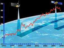
The average height of the sea level has risen by 20 centimeters in the last hundred years and the rate of rise is increasing as the Earth continues to warm. In order to understand the consequences of sea level rise, you must first accurately document them, says NASA

At Vandenberg Air Force Base in California, preparations continue for the launch tomorrow (Friday) of NASA's Jason 2 surface topography mission. This satellite will measure the rise of the sea level. This week the last tests were conducted before the launch. The satellite will be launched into space on top of a Delta 2 rocket.
In economics, a metaphor is used that says "a tidal wave raised all ships" and means an overall improvement in the economy that helps everyone. While this is a good thing economically, when it comes to the actual oceans, sea level rise spells trouble for everyone.
The average height of the sea level has risen by 20 centimeters in the last hundred years and the rate of rise is increasing as the Earth continues to warm. The melting of the ice in Greenland and Antarctica may raise the sea level by more than a meter in the next century. One of the obvious consequences of the process will be the loss of land to the rising water. Another projection would be more complex but no less problematic - warm oceans could fuel more powerful storms. Environmental changes can affect life in the sea, such as coral reefs and fisheries, and changes in ocean currents can cause drastic changes in Earth's climate.
The most important thing that can be done to advance the face of evil is to understand the past and the present. As for sea level, the first step must be to accurately measure it, a challenge in itself. Records of past sea level come from the average readings of tide gauges at many sites. However, since the launch of the Topex/Poseidon satellite in 1992, followed by Jason-1 in 2001, scientists have an accurate measurement of sea level in the oceans every ten days. The Ocean Surface Topography Mission/Jason-2 satellite is scheduled for launch tomorrow, June 20.
"Without recording the data, we will have no basis for evaluating the changes," said the project manager of the new satellite, Li-Leung Fu, from JPL. He compared sea level records that began with the Poseidon satellite to measurements of carbon dioxide concentrations in the air that began in the XNUMXs at the Mauna Loa Laboratory in Hawaii. "The data from Mauna Loa proved that carbon dioxide concentrations did increase as expected, and they were the basis for our understanding of the greenhouse effect," said Poe. The height of the oceans is another basic figure about our climate. The key is to collect accurate and well-calibrated information over a long period of time."
Satellite measurements of sea level do much more than just document and quantify the changes. They also serve as a primary tool for understanding how these changes occur and what this will do to the Earth. "Sea level rise is the most obvious result of global warming" says Poe. "Over 80 percent of the heat in global warming is absorbed by the oceans and only the remaining 20 percent warms the air, the ground and melts the ice." Warm water and melting ice are the two main factors contributing to sea level rise. Hot water expands and requires more volume than cold water. Glaciers and sea ice caps add fresh water to the oceans, increasing their volume again. "In order to predict what will happen in the future, it is necessary to separate the different contributors," said Fu.
A satellite that serves as an altimeter that measures the exact height of sea level in the open ocean is one of three ocean observation systems that are used jointly to identify the share of each of the sources of sea level rise. The other two are the gravity-sensing twin Gravity Recovery and Climate Experiment (Grace) satellites, and the array of Argo floating laboratories, operated by the National Oceanographic and Atmospheric Administration - NOAA.

8 תגובות
Yehuda
There are waves, there are tides and there are measurement errors. These are all noises. In my estimation, the satellite performs tens of thousands of measurements per year. In calculating the average, all the noises are zeroed out and then the remaining average may reveal deviations of the order of a centimeter per year - which is the desired signal - a change in sea level.
Your final conclusion is correct. In any case, two separate measurements are not compared.
In fact, as I thought, apparently the measurement error is greater than the measured deviation and each device that measures reaches a different result.
In fact, the Argo data showed no warming at all, while the combined Jason and Grace data did.
I am afraid that only a range of years will show a change significantly greater than the measurement error.
Good Day
Sabdarmish Yehuda
It is recommended to read the original article (according to the link above) because the questions raised by Ma'ale Yehuda are discussed there to a certain extent in the untranslated part.
to Arya Seter
It is about a height change of several tens of cm in a century, which is about a cm in a year or a mm in a month or fractions of a mm between measurements. Measuring such a change in the sea, waves, tides, etc. is not simple.
good evening
Sabdarmish Yehuda
Yehuda
Where does it say that the system is supposed to measure height changes of fractions of millimeters?
It is interesting how such a measurement system works, which has to measure height changes of millimeter particles in a wavy sea of tides and tides, and does it from an altitude of hundreds of kilometers.
Sabdarmish Yehuda
To my father, the editor of the website, it is not stated in Wikipedia what time the satellite will be launched