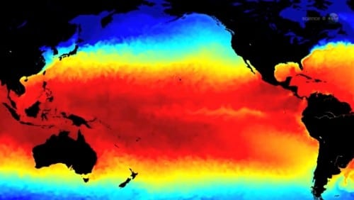
The sea surface height and temperature pattern is reminiscent of the way the ocean looked in the spring of 1997, says Bill Pechert, a climatologist at the Jet Propulsion Laboratory. "These data predict a strong El Niño".
Global warming deniers fixate on the 1998 data to prove that there was no warming in such and such years. Their idea is to catch an especially warm anchor year in the decade before the turn of the century, and calibrate their scale accordingly. 1998 was a continuation of a strong El Niño year that began in the summer of 1997, and high temperatures were recorded. NASA and NOAA estimate that many characteristics of the weather in the Pacific Ocean from the beginning of 2014 show a great similarity to those of 1997.
Every ten days the French-American satellite Jason-2 maps all the oceans, monitors changes in sea level - a way to measure the wall of the upper layer of the oceans. Since 70% of the Earth's surface is covered by water, the information is essential for global weather and climate forecasting.
Recently, the satellite saw something brewing in the Pacific Ocean - and it looks a lot like 1997. The sea surface height and temperature pattern is reminiscent of the way the ocean looked in the spring of 1997, says Bill Pechert, a climatologist at the Jet Propulsion Laboratory. "These data predict a strong El Niño".
A NASA video examining the evidence of El Niño development in the Pacific Ocean
"We cannot say for sure whether El Niño will actually develop in 2014 or how strong it will be," explains Mike McFadden, from the Environmental Research Laboratory of NOAA - the National Oceanographic and Atmospheric Administration - a sister authority to NASA, "but the Jason 2 data reinforces other evidence published in the month Passed by NOAA.”
"Jason sees series of "Kelvin waves" - large ripples at sea level moving along the Pacific Ocean from Australia to South America. Weather forecasters closely monitor this phenomenon because these waves can herald the El Niño phenomenon.
The two phenomena: Calvin and El Niño waves are connected by the wind. The trade winds in the Pacific Ocean move from east to west and push water warmed by the sun towards Indonesia. As a result, sea levels near Indonesia are about 45 centimeters higher than near Ecuador. The researchers call the phenomenon a "warm pool", and it is the largest reservoir of warm water in the entire planet.
However, sometimes, the trade winds stutter for several days or weeks, sometimes the phenomenon occurs at such a level that causes these waves to return to the direction of the American continents. "These are Kelvin waves," says McFadden. "It's not unusual to see a few of these every winter."
The El Niño phenomenon occurs when the trade winds die down not just for a few days but for many months. Kelvin waves cross the Pacific Ocean like wagons, raising the sea level and leaving warm water at the equator in their path.
On May 8, the National Center for Environmental Prediction predicted a 65% chance of El Nino developing during the summer of 2014.
The El Nino of 1997-8 was a textbook case," said Passert. "At that time we received data from the Topex/Poseidon satellite, the predecessor of Jason 2. The sea level map showed white bumps, indicating a height of 10 centimeters higher than normal, moving along the equator from Australia to South America.
"The same phenomenon repeats itself in 2014" says McFadden. "The Kelvin wave series is generated by local westerly wind bursts in the western Pacific that started in mid-January 2014 and are moving eastward. The excitement grew when a third weakening of the Pacific trade winds occurred in mid-April.”
Oceanographic scientists from NASA and NOAA carefully monitor the Pacific trade winds. The tipping point for declaring a significant El Nino would require a longer and larger collapse of the Pacific trade winds, which would indicate changes in weather all over the world.
"The situation will be much clearer during the next two or three months. Then we will know whether these developments are the harbingers of a big El Niño or an El Niño of any kind." McFadden said.

8 תגובות
It's exciting to see what will happen, not that I'm wishing El Nino, which last time hit so hard that it changed the climate, but I think this is the first time that scientists make a prediction in terms of months and not decades, we'll see each other in three months, the results soon.
What is a "chance of 655"?!
Thanks for the link Oren.
The El Nino of 19978 was a textbook example
Why not go through the text before posting???
Here is my father:
http://www.nature.com/news/no-evidence-for-or-against-gravitational-waves-1.15322
It will be taken care of, I would appreciate a scientific source.
my father
Father, it seems to me that it is appropriate to refer to the news that was published a few weeks ago regarding (probably wrong) testimony to the Big Bang:
Evidence from the Big Bang? "Wrong, it's space dust"
http://www.ynet.co.il/articles/0,7340,L-4527065,00.html