Researchers examined what happens under the city's asphalt non-stop - and what seismic tremors cause cars, pedestrians and cyclists
Tel Aviv is a city with about half a million inhabitants and several hundred thousand more who come to it every day for work, entertainment and commerce. So you can say that our asphalt is crowded most of the time. But what happens under the sidewalks, bike paths and roads? And why do we have to be interested in it? This is exactly what the team is investigating from the Porter School of Environment and Earth Sciences and the School of Electrical Engineering At the Ivy and Alder Fleishman Faculty of Engineering They came to explain to us.
WAZE Seismic
Dr. Ariel Leloosh from the Department of Geophysics In the School of Environment and Earth Sciences, usually deals with earthquake research and subsurface imaging. In his research in Israel and around the world, he listens to vibrations that originate deep below the surface of the ground, through seismic waves that propagate in the subterranean medium and are picked up by special sensors. But in the research that he led together with Chen Cohen, a doctoral student in electrical engineering from the Faculty of Engineering, who specializes in the worlds of optics and machine learning, and Roi Mazuz and Oz Tamoki, undergraduate students in electrical engineering and physics, he actually sought to test how it is possible to obtain accurate data on what is happening on the roads and sidewalks of Tel Aviv in a way Simple and cheap, to improve the way the city is planned and maybe even prevent accidents and reduce possible damage from earthquakes. The research relies on machine learning and seismic sensing using optical fibers that are buried underground and pick up, among other things, the movement of vehicles and pedestrians above them. It turns out that it is possible and even makes it possible to track vehicle traffic throughout the city and monitor the areas that are prone to disaster in the event of an earthquake.
Together with his partners in the project, Ariel contacted the manager of the computer systems implementation department at the Tel Aviv municipality, Mr. Avi Haddad, and explained to him what he wanted to do: give the municipality a tool for smart urban planning. All the lights were on in the city hall. The pilot was approved with a request: Please create for us a seismic WAZE that will help us, as much as possible, to get a complete picture of the traffic situation in the city.
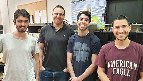
Exploring Tel Aviv from below. From the right: Oz Mamtoki, Chen Cohen, Dr. Ariel Lellosh and Roy Mazuz
Anonymous and cheap information
Through the municipality's communication room, the researchers connected to a fiber about a kilometer long, which was buried about a meter below the ground. Luckily for them, they didn't have to get dirty and lay the fibers themselves - they 'caught a ride' on fibers that exist in the field and are not currently being used. "When we say 'connect to the fiber,' we simply need its end, meaning that if there is a control room from which all the fibers come out - it is enough for us to be there," explains Oz.
Using a special optical model, which they connected to the communication cabinet, laser pulses are sent in a planned way into the fiber. The model knows how to analyze the reflections of the laser and translate them into the way the fiber vibrates.
But why do you even need it? After all, there are cameras and Waze. "The answer is complex," says Dr. Lelouch. "The greatest importance of using our data is that the fiber gives complete and anonymous information. That is, we don't need a camera that reveals the vehicle's license plate and the driver's face, and we don't need to share our location with Google and Waze. On the other hand, you can always see the location of the vehicle. If I drive, for example, without turning on the Waze - no one will know that I drove, and then there may be information that is ignored, while the use of the fiber allows me to reach the completeness of the information. We will be able to know that a private car and a truck and a motorcycle were now traveling, but we will not have to reveal the personal information of the drivers who just passed by the delicatessen in Eben Gvirol on the way."

"We want to release statistical information on simple things that the municipality is interested in, such as how many times vehicles drive at excessive speed or in which lanes," adds Roi.
In addition, Dr. Lelouch talks about the financial issue. "The cost of placing the cameras throughout the city reaches hundreds of thousands of shekels per camera. They are usually put mainly where there is economic justification, and that is why the amount of cameras is limited and does not cover the whole city. I think that in a world where there are already so many fibers it is possible to do a more complete mapping of the traffic, perhaps also of small streets in Tel Aviv, which are precisely where there are always traffic jams due to turning or traffic lights, but they are not photographed."
The sensor that sees around the corner
With the vast amount of information received, quite a bit can be done. "At the level of urban planning, you can get more complete insights. For example, how it is possible to more correctly disperse congestion on the roads, where to pave more bike lanes or pedestrian walkways for the public's enjoyment, and more. And there is also the issue of earthquakes," says Dr. Lelouch. "Perhaps it is not directly related to vehicles, but it is possible to identify areas where, due to the specific structure of the soil, there is an increased risk in the event of an earthquake. That is, if seismic energy already arrives, it is less restrained or even amplified, so it may be that an area or a street or even a specific building will be more prone to disasters."
According to him, as of today, the maps that define the standard of construction in the State of Israel divide it into a number of individual areas according to the degree of danger from earthquakes, which is mainly taken into account in proximity to seismogenic areas along the Dead Sea fault. However, there is no such high-resolution division as the information from the optical fibers can offer.
Dr. Lelouch presents another facet of the importance of the new information that can help us in the more distant future: "I believe that in the era of the autonomous vehicle, information from optical fibers will be able to tell the car 'be careful, someone is about to enter your intersection and your camera doesn't see it yet.' Our challenges are very big - processing a huge amount of information and transmitting it. But basically, if you are a vehicle traveling on the road, you have no way to escape the fact that you have weight, and yes, you are distorting the ground, so the optical fiber will 'hear' it."
'Watch out, someone is about to enter your intersection and your camera doesn't see it yet'
A jungle of disturbances
The experiment lasted about a week, during which information was collected continuously. The team built a model that studies the seismic patterns that are picked up by the fiber and knows how to tell what is happening in terms of the movement of vehicles and even pedestrians, and obtain a preliminary classification according to the type of vehicle. There are also preliminary results in the context of the identification of the travel route, which is particularly relevant for monitoring unwanted traffic on public transport routes. Now the researchers are working on "cleaning and filtering" the information in order to optimize the performance of the model.
"When you do an experiment for the first time, you collect the densest information and the highest resolution possible. Now we understand that the signature of the vehicles and the pedestrians is relatively simple, and in the future we will be able to change it to reduce the load in collecting and processing the information, says Dr. Lelouch. "The big challenge is to teach the computer to analyze and separate things, and it is getting better and better," adds Chen.
Exclusive solution
If the pilot continues, the municipality will be able to test many different effects in the context of urban planning. For example, to know whether the many bicycle paths that have been paved throughout the city are indeed used by the residents, which streets pedestrians prefer to walk on and then to develop additional open walking paths to continue making the city more inviting for pedestrian or non-motorized traffic.
"If it seems that the initial results of this research are successful, and I have a feeling that they are, in the future we will plan a fiber route that runs through the streets of the municipality. It is important to get more information about them," concludes Dr. Lelouch. Now the team is looking for additional students and doctoral students who are interested in taking part in the project. If you are looking for a topic for a master's or doctoral thesis, contact Ariel.
More of the topic in Hayadan:
