Since Xsini orbits Saturn and not Titan, tracking the moon is not continuous. Observations towards the moon are only possible while it passes by it on average once a month. Therefore its surface is slowly exposed
introduction
In light of the success of the Cassini spacecraft in fulfilling its mission, it was decided to extend its work program and it continues to orbit Saturn and will be used until the fuel supply runs out/
According to NASA's estimates, this will happen around May 2017. Then you will aim to fly into its atmosphere. A move similar to the way the Galileo spacecraft completed its mission. It was aimed into Jupiter's atmosphere and transmitted data until it was crushed inside. The large Titan among Saturn's moons is the most intriguing and the information coming in continues to surprise all the time.
The accepted assessment was that Titan was a perfect sphere. Cassini's observations have shown that Saturn's gravity distorts this sphericity. The poles are flattened to a small extent due to Saturn's gravity and at the equator the moon takes on a sort of oblong shape. This has meaning in terms of the internal structure of the moon (1).
Since Xsini orbits Saturn and not Titan, tracking the moon is not continuous. Observations towards the moon are only possible while it passes by it on average once a month. Therefore its surface is slowly exposed. Due to its cloud cover, ground photography can only be done in a limited range of infrared wavelengths. The way the overall picture is built is like a crossword puzzle and very slow (2).
Until September 9.2010, over 20,000 visible and infrared photographs were broadcast to Israel. Photographs in visible light make it possible to view some of the clouds and photographs in infrared make it possible to view the ground as well. Due to distortions created when viewing the moon on its night side, it was necessary to filter them. Only 2000 photographs could be used to distinguish the cloud activity. Due to the extension of the mission, the researchers were given the opportunity to observe seasonal changes in the clouds (3). Since Xaxini entered orbit around Saturn in 2004, until 2017 the duration of its activity is 13 years. mundane A year of Titan is equal to 29.5 earthly years and therefore viewing the moon is during its half year.
topography
Comparing the poles to the equator, it turned out that the land surface in them is 700 meters lower than the equator area. On average, the height of the ground can reach 400 meters (4). The mountains on Titan were formed during tectonic activity when the crust entered a phase of deep freezing. A procedure opposite to what happened and is happening on Earth today. In the world we live in, earthquakes still occur and rift valleys are created as a result (5).
North of the Aaru region near E 0 13 – N 0 52 there is a formation whose maximum height is 1400 meters above its surroundings (6). Northwest of Xandu there are two parallel mountain chains. Their maximum height is 1900 meters. It is estimated that these mountains were formed when the outer layer of the crust underwent folding (7).
In the Adiri region there are parallel chains of mountains that are 250 meters above their surroundings (8). It turned out that Titan's ice crust is similar to the frozen land in Siberia. Since the frozen ground is partly liquid. It was estimated that the maximum height of the mountains would not exceed 1900 meters and indeed so far no mountains have been found whose height is beyond that (9).
Xando area
One of the most prominent places on Titan is the Xando region, whose dimensions are the size of a continent. In infrared and radio images it appears bright. In the past it was raised above the surface. In the photographs taken on February 22.2.2008, 10, it became clear that it is relatively flat, even though in the past tectonic forces acted on it that led to both its expansion and compression, processes that are still not fully understood (5). Dry channels are estimated to be found in this place. In one of the photos, you can see that the direction of flow of these channels is outward into a delta-shaped drainage basin that is up to 11 km wide. The presence of mountainous material in the place indicates that in the past tectonic forces operated in Xandu that shaped it (5.2008). The channels found in the southern and lower regions of Xandu appear brighter compared to what is seen at the landing site of the Huygens spacecraft. In the photographs taken on 12 these channels are the brighter compared to the radar photographs. According to the explanation given for this phenomenon, the origin of this brightness is the accumulation of spherical and transparent sediments that were more tightly packed than those found at the Huygens landing site (XNUMX).
Bun configuration
In a photograph taken on 22.5.2012 at W 0 203 – N 0 38.5, a domed relief resembling a bun was identified and similar to it is also found on the planet Venus. The width of the relief is 70 km and an angular depression is visible on it, the distance between its two sides is 60 km. From a comparison with the corresponding configuration on Venus (found at the summit of the Kunapipi Mons volcano), it was hypothesized that the angular and sunken configurations on Titan originate from the cracking that occurred during the uplift of the surface by forces that acted on the surface (13).
Malls and canyons
בA photo taken on 25.5.2009 identified a network of canyons carved into the ground by a strong and large flow of methane in the rivers. In this photo you can see that the flow was from the high levels to the low plains. You can also see that the rains are eroding the surface. The canyons in this area appear to have been filled over time with a fine granular material that appears dark in X-rays. At a later date another process probably took place. The fill material was carved by a large river. The location of the photograph is W 2400 – S0 71 and its dimensions are 289-335 km (14).
A photograph taken on 28.12.2009 at W 0 213 – N 0 41 shows low mountains and ravines. The question that was asked is how were the crevices formed? Two explanations have been proposed. According to one explanation they were formed by forces within Titan including those that lifted the surface and cracking caused by the melting of the rock that penetrated the crust. According to the second explanation, winds and rains created river channels that can row inside the rock (15).
Sources
1. Bergeron L - "Titan Saturn's largest moon, icier than scientists thought" 6.12.2012
http://www.spacedaily.com/reports/Titan_Saturns_Largest_Moon_Icier_Than_ Scientists_ Thought_999.html
2. "Piecing together a global map of Saturn's largest moon" 7.10.2011
http://www.spacedaily.com/reports/Piecing_Together_A_Global_Map_Of_ Saturn_ Largest_ Moon_999.html
3. "Spring on Titan brings sunshine and patchy clouds" 23.9.2010
http://www.spacedaily.com/reports/Spring_On_Titan_Brings_Sunshine_And_ Patchy_ Cloud_999.html
4. Shiga D.-"Titan's squashed shape hints at soggy interior" April 2.4.2009, XNUMX
http://www.newscientists.com/article/dn16894-titan’s-squashed-shape-hints-at -soggy -interior.html
5. "Titan twisted in frigid imitation Earth" 13.8.2009
http://www.spacedaily.com/reports/Titan_Twisted_In_Frigid_Imitation_Earth_999.html
6. PIA13330: Mountains north of Aaru on Titan
http://photojournal.jpl.nasa.gov/catalog/PIA13330
7. PIA13331: Mountains on the northwest border of Xanadu Titan
http://photojournal.jpl.nasa.gov/catalog/ PIA13331
8. PIA13332: Mountains near Adiri on Titan
http://photojournal.jpl.nasa.gov/catalog/ PIA13332
9. "Avoid swimming in interplanetary lakes" 23.4.2010
http://www.spacedaily.com/reports/Avoid_Swimming_In_Interplanetary_Lakes_999.html
10. PIA11822: Skirting Xanadu's southern boundary
http://photojournal.jpl.nasa.gov/catalog/ PIA11822
11. PIA12989: Xanadu's channels and dunes
http://photojournal.jpl.nasa.gov/catalog/ PIA12989
12. "Rock and roll: Titan's gem tumbler" 13.5.2010
http://www.spacedaily.com/reports/Rock_And_Roll_Titan’s_Gem_Tumbler_999.html
13. PIA16165: Titan's hot cross bun
http://photojournal.jpl.nasa.gov/catalog/ PIA16165
14. PIA 12036: Southern canyons of Titan
http://photojournal.jpl.nasa.gov/catalog/ PIA12036
15. PIA12496: New urinkles on Titans
http://photojournal.jpl.nasa.gov/catalog/ PIA12496

4 תגובות
It's a shame they don't try to land the spacecraft on Titan instead of crashing it on Saturn.
It could have been a perfect ending
,Thanks
Grooves can be translated as ravines..
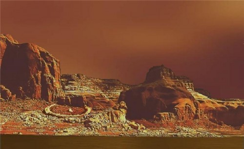
Wow, what a painting, really talented and have a developed imagination there at NASA