A new study examined the relationship between storms of the type that caused the devastating floods in the Negev and the temperature in Israel, and found that more powerful storms were observed in warmer weather. What will these storms look like due to climate change?
By David Sandler, Angle - Science and Environment News Agency
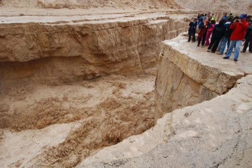
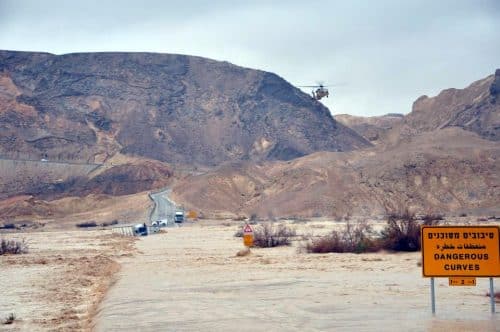
Only about two weeks ago we received a painful and tangible reminder of the terrible power of extreme weather events. The heavy rains that turned into floods in the Judean and Negev desert claimed the lives of 13 people, including 10 teenagers who are members of the Bnei Zion pre-military training school. The incident was defined as the worst nature trip disaster in Israel, and it also carries many question marks regarding the conduct of those responsible and the preparation that was required.
But alongside the human factors, it is also important to try and understand the weather phenomena that created the danger. Flash floods, such as those that happened recently in the Negev, are often characterized by short periods of heavy rain. In areas where the soil does not allow effective percolation (such as the loess soil that is common in the Negev), the soil is quickly sealed and the rainwater flows downhill and finally drains into a central river route, creating a flood flow. In many cases, rains of this type fall under the definition of "convective rains" - warm and moist air, which due to instability in the atmosphere rises up quickly spontaneously and condenses into drops, then melts on the ground.
Now, A new hydro-meteorological study of scientists from the Hebrew University, Switzerland and Australia aims to improve our understanding of this elusive and dangerous type of rain, and to reveal the connection between the intensity of convective storms and the temperature in Israel.

The researchers used rain radar data located in Israel, and analyzed thousands of rain events that occurred in four different regions of the country (above the Mediterranean Sea, Carmel, the northern Negev and the Judean Desert) from the early XNUMXs to the present day.More accurate alerts
Hydrologist Dr. Nadav Peleg, one of the leaders of the research, explains: "The convective rain can usually be characterized as a 'cell' of rain with high intensities, which rains for a few minutes. Therefore, if the cell passes over the Hikvat basin and rains a large amount of rain in a short period of time, a flash flood will occur in the river channel. A number of studies carried out in the hydro-meteorology laboratory at the Hebrew University Find a direct relationship between the characteristics of the convective rain cells to create floods. For example, convective cells that move slowly along a channel, from upstream to downstream, are more likely to create a flood."
According to Peleg, a better understanding of the convective rain cells can improve the models we use for weather forecasting, and will enable the provision of more accurate warnings for spot extreme weather events, sometimes hours before they materialize.
Hotter - more powerful
The main conclusion that emerges from the analysis conducted by the researchers is that when the air is warmer, the convective rain becomes stronger. Although we are used to associate rain with cold weather, warm air can contain more moisture and is sensitive to atmospheric instability. For the convective rain in Israel, it was discovered that it strengthens by about three percent on average for each degree of warming, whether in the cool Carmel or the arid Judean desert. Perhaps more worrying is the finding that on hot days, extreme rains become even more extreme - the intensity of a typical rain event from the upper percentile (that is, rain stronger than 99 percent of the sample) will also increase by about 1.3-2.4 percent per degree.
While spot cells are strengthening, the total amount of rain in the areas tested actually decreased. That is, an increase in temperature decreases the availability of precipitation, and those that do rain tend to do so with a higher intensity. According to Peleg, this may affect our water resources, and possibly also the frequency and intensity of future floods.

Storms in a warming world
These conclusions align well with the scientific consensus regarding the climate changes expected to occur on Earth in the 21st century. According to the popular estimate, the predicted increase in global temperature (due to human emissions of greenhouse gases) will be accompanied by with increasing frequency of extreme weather events. In the Middle East in particular, a reduction in the total amount of precipitation is expected, but at the same time an increase in the intensity of extreme rain events. In view of the new research, will the predicted increase in temperatures also increase the strength of the convective storms?
According to Peleg, the analysis carried out in the study is based on the current climate, and it is difficult to conclude from it what the trend will be in the future. "In order to give a better assessment of the expected changes in the scales of the convective rain, taking into account the uncertainty related to climate change, a climate model is needed that can simulate the climate with an extremely high time and space resolution - of minutes and hundreds of meters," he explains.
An example of the climatic uncertainty is the humidity in the atmosphere. Although the predicted warming encourages the extremity of the convective rain, the humidity in our region is also expected to change and affect it. So in fact, there may not be enough water available to "fuel" the intensification of the storms according to the ratio measured today, and that the extremism itself will moderate. This is a rare case where the aridity of our region actually constitutes a certain advantage. In similar studies done on rainfall in Western Europe, it was found that the intensity of the rain increased between 7 and 14 percent for each degree, mainly thanks to the abundant water available there.
Although the look to the future is not reassuring, we can hope that additional studies (such as those that continue to take place today at the hydro-meteorology laboratory in Jerusalem) will be able to help us better understand extreme events, prepare for them and avoid disaster. Perhaps even more importantly, if the world knows how to fight the climate crisis today, we may also be able to prepare ahead of time and reduce the extent of the expected damage.

One response
Scientists speculate but are not sure that Mars was once similar to Earth. With water and atmosphere that froze, evaporated.
Not sure because maybe Mars doesn't have the mass to gravitationally pull a non-thin atmosphere, and maybe it doesn't have a magnetic field that protects from particle radiation - that is, it didn't have one hundreds of millions of years ago. If it is true even as a hypothetical thought idea and not true,
We should learn from this that we are destroying our only star.