New NASA satellite images have shown the results of the disaster created by the floods caused by Cyclone Nargis in which about XNUMX people were killed

The first cyclone of 2008 in the northern Indian Ocean was disastrous for Burma. According to meteorological reports, winds blew at a speed of close to 200 km/h and momentary wind gusts that even reached 250 km/h, equivalent to a 3-4 intensity hurricane, were blowing on the coast of Burma. News reports state that 100 people have been killed and thousands more are missing since May 5.
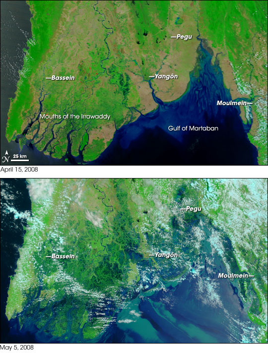
It is difficult to distinguish flood waters in satellite images obtained in the visible spectrum, especially when the water is muddy. This pair of images from the MODIS Medium Resolution Spectrometer aboard NASA's TERRA satellite combine visible and infrared light to make floodwater visible. The water is blue or almost black, the vegetation is light green, and the soil is yellowish-brown. The clouds in these images appear white or light blue in color.

In the photo taken on April 15, 2008, the rivers and streams are clearly differentiated against the background of vegetation and farmland. The Irrawaddy River flows south through the left part of the image, and splits into thousands of channels in the delta area. The marshland near the beach looks a deep blue-green color. The cyclone crossed the mouth of the river and followed the coastline to the northeast.
NASA's Terra satellite photographed the area again on May 5, 2008, and in this photo you can see the devastation caused by the cyclone.
The photo taken on May 5 shows the entire coastal plain flooded. The pit fields and agricultural areas seem to be very damaged. For example, the capital region of Yangon (Rangoon), which has a population of over 4 million people, is almost entirely surrounded by floods. Some relatively large cities - 100-500 thousand inhabitants are in the affected area. Mudflows in the Gulf of Martaban are painted turquoise.
The image was taken with a maximum resolution of 250 meters per pixel. The MODIS rapid response team photographed the affected area twice a day in a variety of resolutions, including in almost natural colors.

4 תגובות
What wicked cynicism...
What do you think they could have done if they had known in advance?…their whole life as they knew it would have gone one way or the other…just look at what we are doing to our world…
By the way.. this thing really inspires awe.. it's like footage from a disaster movie and not reality.. it's just unbelievable that so much has naturally become a part of the sea like that..
Regardless..I also don't exactly like Hamas Fatah and every young man in the city who decided to open a local branch of Hezbollah in his yard...so it's not political..just a human matter..really dangerous.
There are already reports that the aid products are reaching supermarkets in Burma.
The military junta in Burma is holding its people hostage just like the Hams are doing in Gaza.
This junta "forgot" to warn the citizens of Burma about the approaching cyclone.
It is absolutely clear that most of the aid that will be given to the junta will not reach those in need.
A fucking world.
Besides, Happy holiday
Sabdarmish Yehuda