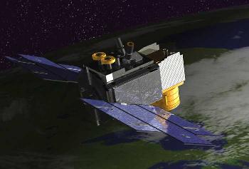
The ICESAT satellite weighs 297 kg and is designed to measure the ice sheet covering Greenland and Antarctica, so that scientists can know whether the sea level is rising or perhaps falling
A NASA satellite that measures changes in the Earth's polar ice caps was launched into space on Monday after a delay of almost a month. The $2 million Delta 282 rocket carried the ICESAT satellite and a smaller CHIPSAT satellite on January 12 from Wandenberg Air Force Base in California. As mentioned, it is launched jointly with a smaller satellite, the Cosmic Hot Interstellar Plasma Spectrometer satellite, or Chipset for short, which will search for the glow of the interstellar medium - the gas that fills the space between the stars.
Mission managers say everything is going well so far. It was said an hour after the launch that the two satellites were placed in a polar orbit at a distance of 604 kilometers one and 563 kilometers the other.
The original launch was planned for December 19, but the launch was postponed to January 11 due to technical reasons. The launch was delayed another day due to another problem that prevented the engineers from loading helium to propel the rocket.
The ICESAT satellite weighs 297 kg and is designed to measure the ice sheet covering Greenland and Antarctica, so that scientists can know whether the sea level is rising or perhaps falling.
A smaller satellite, weighing 59 kilograms, called the Cosmic Hot Interstellar Plasma Spectrometer, or CHIPSat for short, will provide information about the hot gas between the stars.
The Icesat satellite will try to examine whether the large ice sheets are also melting (update)
19.12.2002
By: Avi Blizovsky
Direct link to this page: https://www.hayadan.org.il/Icesat1.html
Update 19 / 12 / 2002
The launch of the ICESat and CHIPSat satellites planned for today, 19/12/2002 on a Delta 2 rocket manufactured by Boeing has been postponed.
NASA expects to launch these two spacecraft no earlier than January 8, 2003.
Hence the original news dated 18/12/2002
NASA scientists hope to gain insight into the future of sea level when a laser-equipped satellite designed to measure the smoothness and size of the ice sheets is launched this week.
The satellite named Ice, Cloud and Land Elevation Satellite or Icesat is supposed to spend at least three years continuously checking the height of the ice sheet covering Greenland and Antarctica.
This will make it possible to answer the question of whether these ice layers, which are up to 3 kilometers thick and which contain more than 16 million cubic kilometers of fresh water, are growing or shrinking.
"We don't know what's really going on," says Jay Tzwali, the project's lead scientist at NASA's Goddard Center in Maryland. "Not only do we not know what is happening today, we do not know what is going to happen in the future."
Icesat is scheduled to be launched aboard a Delta 2 rocket Thursday (19/12/2002) from Vandenberg Air Force Base in California.
The question that the $282 million Icesat project is trying to solve is an important one: if more ice melts from the ice cap than the new ice that accumulates from the snow, the water will cause a global rise in sea level. The scientists fear that this rise could cause flooding in coastal areas and change the patterns of currents in the oceans that play an important role in determining climate conditions.
The sea level is rising by more than a centimeter per decade. About half of the rise comes from the melting of small glaciers and the warming of the ocean water, which causes the water to expand as the temperature rises. The reason for the second half is unknown, although the melting of the ice sheet is suspected.
The Inter-ministerial Committee on Climate Change estimates that the sea level will increase by about 28 centimeters over the next century (plus or minus 15 cm). Tzvali estimates that the measurements they will make using the Icesat satellite will reduce the level of uncertainty.
Boeing's Yale flew the ICESAT and CHIPSat satellites into space
For the full story on CNN
icesat to the satellite site
