This is what Dr. Karsten Linz, business development officer at SAP, said ● According to him, "The partnership between us and the European Space Agency paves the way for a new field of geospatial business applications; This will bring businesses a competitive advantage, create more high-tech jobs and improve the way of life"
The collaboration between SAP (SAP) to the European Space Agency brings the announcement of a new service on SAP's HANA platform - the Earth Observation Analysis Service.
"It will be a kind of market where it will be possible to receive information processed according to the customer's demand. We have broken down these services into micro-services so that customers, partners and even start-up companies can create space applications on the HANA platform for urban, environmental, agricultural uses, natural disaster monitoring and more," says Dr. Carsten Linz, business development officer at SAP, in an interview withPeople and computers During the SAP TechEd conference that took place last week in Barcelona, Spain.
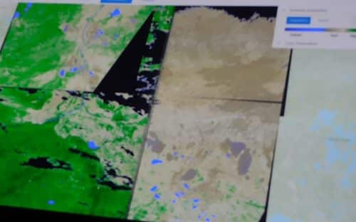
According to him, "The European Sentinel satellites are the largest providers of Earth observation data worldwide. One of the big challenges is to convert the mountains of data so that they become customer-specific information. Processing on a large scale is what is needed to answer this challenge and thus bring the data to the users and not the other way around.
"The service provides an application programming interface (API) that allows continuous access to historical satellite data and real-time data," Linz said. "This is expected to be used by government agencies and companies in a variety of industries - from insurance to mining, services and retail, to gain insights into questions such as where to place new power lines, where to build a new store, and the like."
Calculate costs and risks and get insights
"Our partnership with the European Space Agency paves the way for a new field of geospatial business applications, so that the gap between traditional Earth observation and the digital business world can be bridged," added Linz.
“This opens up a bright future for applications such as digital agriculture, gas pipeline management and improved planning of smart cities. It will bring businesses a competitive advantage, create new high-tech jobs and improve the lives of all citizens."
In the opening session of the event, the insurance company presented Munich Re The use of the Earth observation analysis service to gain insight and predict the potential future impact of disasters such as earthquakes, floods and forest fires, from historical and current data.
"Every year, fires affect nature, people and their homes and businesses," he said Andreas Seibert, Head of Geospatial Solutions at Munich Re. "While the direction and rate of progress of the fire are difficult to predict, leveraging the satellite data allows us to calculate costs and risks related to fires with greater precision, and even get insights into the chances of fires in any given area. This will help us keep costs low for our customers."
According to him, "a comparison of the data before and after and the mapping of the fires over several years will allow us to know exactly where the fire hit and prevent false demands from people who were in nearby areas and were not really harmed."
"We must make sure that the work is systematic"
Sibert concluded by saying that "we can also know with the start of the fire how much money is at risk, and who will be affected. For example, hospitals that will be required to take in all the victims. We also take it a step further - predicting where there will be fires, and applying it to other places. For example, in America there are fires in many areas - but Britain is clean, maybe because of the fog. We take the ESA photos, combine with photos from our customers to understand the risks and to help prevent forest fires in the future."
Nikolaus Hanovsky, director of the ground field in the operations department of the European Space Agency, said on the stage of the opening plenary of the conference that "space missions will always generate enormous amounts of information. We are about to launch a fleet of high resolution satellites that will generate a lot of data and we have to make sense of all the information. This is a continuous flow of data - not a one-time project."
According to him, "ESA is required to take control of a stream of data in a volume we have not seen so far. This will change the entire architecture of operating space missions, which is why we are building collaborations with entities that have such capability."
"We have also reached the limit of our ability to transfer data to users," concluded Hanovsky. "We allow them to process the raw data and use ways to discover data and make information valuable. But we must make sure that the work is systematic - it will change the way we build systems."
In response to the question of the science website, is there a solution to the fact that the space agency's data is public by virtue of its funding, Linz said: "The raw data is indeed public, we analyze and process the raw data."
