Venus, the Israeli Space Agency's research satellite, transmitted the first images from space, including the first image of the Jerusalem area. The image taken using the sophisticated camera of the satellite, allows you to see Jerusalem and its surroundings in an unprecedented quality, while distinguishing various ground details.
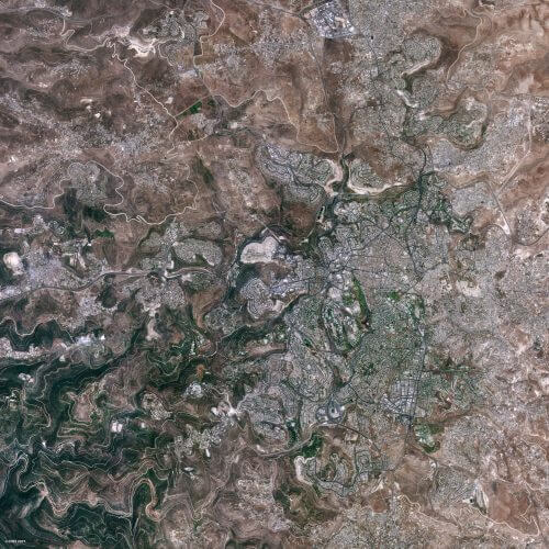
Minister of Science and Technology Ofir Akunis said following the publication of the photos that "You can see the beauty of Jerusalem even from space. The success of the Venus launch is reflected in the first images received from it and this is just the beginning. In the coming years, all of humanity will benefit from the photographs that will help ground-breaking research in the fields of the environment, earth sciences, water and food.'
The Jerusalem area is prone to recurring raging fires, mainly during periods of heat waves, dryness and drought. The information that will reach Monos will help scientists develop new methods for characterizing the ecosystem in the area, for understanding and reducing the risk factors, and thus also for the study of global warming. The image demonstrates the type of information that the satellite will produce in the coming years for the benefit of the studies that will affect agriculture, politics and economics.
The Venus research satellite launched into space at the beginning of the month is a collaboration between the Israeli Space Agency in the Ministry of Science and the French Space Agency. The satellite was built by the aerospace industry, and includes a multispectral camera with 12 different wavelengths developed by Elbit, and a new electric motor developed by Rafael. The satellite was successfully launched on August 2, and since then has undergone a series of tests and examinations of the various systems, which were successfully completed. A counter is created by 12 different sensors, each of which takes pictures at different wavelengths, so
Each image produced by Venus consists of 12 different layers of information and covers approximately 740 square kilometers. Thanks to the wide number of colors of the camera, some of which are beyond the visible range of the human eye, it is possible to distinguish details that cannot be detected on the surface of the earth or with a normal camera. In this way, it will be possible to distinguish when the vegetation is suffering from a lack of water, pests, leaking drippers, water pollution in reservoirs, forest fires, and more.
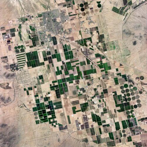
In addition to the image of Jerusalem, the satellite also transmitted images of the city of Marseille in France, fields near Phoenix in Arizona and tropical forests in Peru. The satellite photographs once every two days about 110 different and permanent research areas around the world that represent agriculture, nature and ecology areas, with a resolution of 5 meters and the same photography angle. When Venus passes over Israel, it takes three photographic strips along its length: the Galilee, the coastal plain (including the nearby strip of sea) and the Negev. These areas will include most of the national parks and nature reserves, forests and ecological stations. The photos will be nominated for the benefit of universities, government authorities and research institutes.
The images of Israel arrive at the research center at the Sde Boker campus of Ben Gurion University of the Negev headed by Prof. Arnon Karneali, a center that is an operational arm of the Ministry of Science and Technology. In Israel, the Israel Space Agency invested approximately NIS 5 million in the Ministry of Science to carry out research on the satellite products. One of the first research projects that will use satellite imaging is for high school students from Rishon Lezion and Rehovot with an investment of half a million shekels by the Israel Space Agency.
See more on the subject on the science website:
- A sigh of relief after the first Israeli double launch was successful
- "The fact that developed countries like Italy and France choose to build satellites in Israel proves our capabilities"
- The high school students who will analyze the information from the Venus research satellite
- Interview with the chief scientist of the "Venus" satellite project

2 תגובות
The site is very beautiful, I enjoyed it very much, thank you for a fruitful and enjoyable learning experience
As long as you don't show at least some of the different layers of the multispectral photography and what you can learn from them, it's a bit hard to get an impression of the "unprecedented quality" in the image that doesn't look any different from a low-resolution satellite image of Jerusalem on Google Earth and a host of other satellite image services.