It will improve the level of accuracy of vehicle navigation systems by about 90% and will help in the study of ground movement in our region
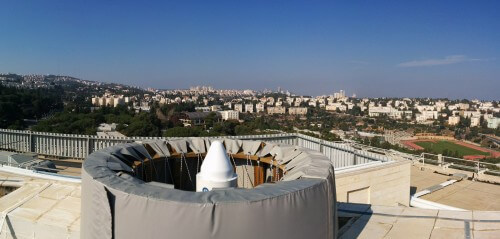
The first reference station in Israel of the EGNOS system - the European equivalent of the American WASS system - was placed on the Technion campus. The establishment of the station is the result of a collaboration between the European Space Agency, the Mapping and Geo-Information Engineering track at the Faculty of Civil and Environmental Engineering at the Technion, and the Aerospace Industry.
EGNOS, operated by the European Space Agency, is an extension of the American GPS system. It consists of three geostationary satellites - that is, satellites located above fixed points on Earth - and a network of ground reference stations (RIMS). EGNOS satellites transmit signals that allow users to get a location across Europe and its surroundings in real time with an accuracy of about one meter.
"The station is of national importance because it will improve the capabilities of the system in our region," explains Prof. Gilad Ibn-Zur, who is responsible for the new station located in the Rabin building at the Technion (Faculty of Civil and Environmental Engineering). "This is a system that will be open to anyone who has a dedicated GPS receiver, and the applications are countless: navigation of air, sea and land transport, guidance systems, mapping systems, navigation applications of all kinds, etc. Since this is a dramatic improvement in the level of accuracy, it is clear that the system is very attractive to anyone who needs an accurate and reliable location."
Prof. Ibn-Zur, a faculty member in the Faculty of Civil and Environmental Engineering, deals with geo-information (geodesy) - determining a position in three-dimensional space on the surface of the earth and in space - and one of his research areas is tracking the movements of the earth's crust. Such tracking requires an incomparably higher accuracy than that obtained from the EGNOS system. "Also in measuring movements of the earth, the GPS system is used, but in a different way than that carried out with the EGNOS system, since these are very small movements and in order to detect them, a very high measurement accuracy is required. The GPS system allows us to measure not only the horizontal movement of the earth but also vertical movements such as the elevation of the Carmel Ridge, which occurs at a rate of a few millimeters per year as a result of the displacement of the earth's crust in the area of the Carmel Rift."
Prof. Ibn-Zur explains that the accuracy depends, among other things, on the quality of the receivers that are used. "Those who use the GPS receiver on their mobile phone can today get a position with an accuracy of about ten meters. Such a level of accuracy obviously helps to navigate a car on the road for example, but sometimes it is not sufficient. EGNOS will provide much higher accuracy in determining a position - order of magnitude of one meter. I, as a researcher who uses sophisticated GPS receivers, can also reach a relative accuracy of a few millimeters - a need that is very critical in tracking the movements of the earth."
