A new feature in Google Earth that allows users to explore space directly from their computer

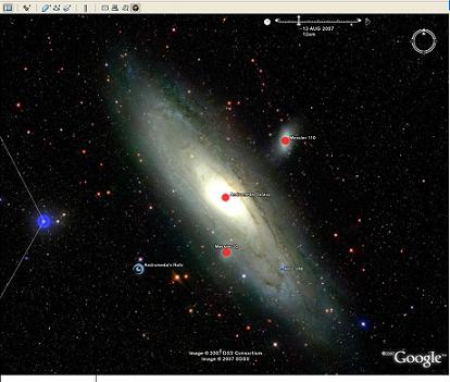
Google announced on Wednesday, August 22, 2007 the launch of Sky, a new feature that allows Google Earth users to view the sky as it appears from Earth.
With the help of Sky, surfers can now float in the sky using Google Earth. The simple and convenient tool allows all Earth users to view and navigate through 100 million stars and 200 million galaxies. High resolution images and informative layers create a unique playground that allows visualization and study of space.
In order to enter Sky, you must update to the new Google Earth version, which can be downloaded for free Then click on Switch to Sky from the view menu in Google Earth or click on Sky in the Google Earth toolbar. The interface and navigation is similar to that of the regular Google Earth, including dragging, zooming, searching, "my place" and selecting layers.
As part of the new feature, Google presents seven layers of information that describe various celestial bodies and events:
* Constellations - from Cassiopeia to Andromeda, the layer connects the dots between the different stars in each group and adds its name to each one. Users can learn about the stars that make up their favorite teams.
* Backyard Astronomy (Backyard Astronomy) - This layer allows the user to click on a variety of place mirrors and data about stars, galaxies and nebulae as they are seen with the naked eye, using binoculars or a small telescope. This layer is suitable for the amateur astronomer who can enjoy a comprehensive and organized way to identify the various components of the night sky.
* Images from the Hubble Space Telescope - the HST layer that provides the user with 129 high-definition images that came from the Hubble - the well-known space telescope of NASA and ESA.
* Moon - The moon layer shows animations of the various moon states and appearances during 2 months.
* Planets - The planets layer shows the other 7 official planets and their position in the sky two months ahead.
* The user's guide to the galaxy - the "User's guide to the galaxy" layer allows surfers to take a vital trip through different galaxies, starting with the Little Bear and ending with the Milky Way.
* Star Life - The Star Life layer takes the user on a tour of the various stages of a star's life cycle.
Sky was created by Google's team of engineers in Pittsburgh who stitched together images from a variety of scientific sources, including the Space Telescope Science Institute (STScl), the Sloan Digital Sky Survey (SDSS), the Digital Sky Survey Consortium (DSSC), the California Technion's Palomar Observatory, the California Technion Center for The United Kingdom Astronomical Observatory (UKATC) and the Anglo-Australian Observatory (AAC). The initiative was born as part of Washington University's participation in Google's Google Visiting Faculty Program, which allows leading scientists to visit Google with their work for a period of 6-12 months.
"We are happy to provide users with rich astronomical images and additional content that will allow them to learn what they are seeing and add their own unique perspective," says Lior Ron, Product Manager at Google Earth. "Thanks to the collaboration with the leading experts in the field, we have turned Google Earth into a virtual telescope."
"Sky is an exciting new feature for anyone who has ever looked up at the sky and wanted to know more," said Sally Ride, a former astronaut and the first American woman in space. "In my opinion, this is a great tool that answers this curiosity."
“Never before has a road map of all the heavens been so readily available. Anyone interested in exploring the wonders of our universe can quickly see exactly where the stunning objects photographed by Hubble are located. "Sky in Google Earth will foster and initiate a new understanding of the universe by putting it on every home computer," explains Dr. Carol Christian of STScl, one of the managers of the Sky team alongside Dr. Alberto Conti.
The announcement comes after a set of NASA layers was uploaded to Google Earth last month. The group presents the exploration of the earth done at NASA and contains three main components, "astronaut photographs of the earth", satellite images and "cover lights". "Astronaut Photographs of the Earth" presents images of the Earth as seen from space from the early 60s onwards, Satellite Photographs presents images of the Earth taken by NASA satellites over the years, while "Lights of the Volume" follows well-lit cities around the world .
To access Sky in Google Earth, the user must download the latest version of Google Earth. The feature will be available in all versions of Google Earth in 13 languages. For more information on Sky you can watch In the demo Or watch Sally Reed and Greg Combs, a Google engineer describe some from Sky capabilities .

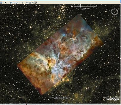
Carina Nebula
About Google Earth
Google Earth combines satellite imagery, maps and the power of Google's search service to make geographic information about the world accessible and useful. Since Google Earth was launched in June 2005, it has been downloaded by over 200 million users.

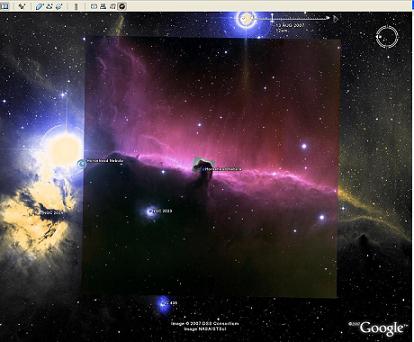
Horsehead Nebula. Photos courtesy of Google Public Relations Office, Euro Tel Aviv

6 תגובות
I write through the iPhone,
It's cool right? without either.
But take it down
Keep it up! Every day another pleasant surprise for sky lovers...
It's just huge!!!
I downloaded it and it's great