It was decided to keep one of the polygons created as a result of the ice activity, which is near the spacecraft, and first dig "normal" soil nearby

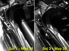
In the left picture, you can see the joint of the robotic evil in a folded state as it was seen on the first day of the spacecraft's immersion, and on the right - on the third day after the arm was deployed away from the lander's deck. Photo: NASA, JPL/Caltech and the University of Arizona
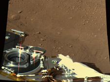
Phoenix mission scientists operating from the control room at the University of Arizona in Tucson sent a command to release the robotic arm and take more pictures of the landing site, and indeed the spacecraft did send back some high-definition color pictures. The Phoenix Imaging System team assembled images taken from the spacecraft's stereoscopic camera on the day of landing, and on the next two full Martian (sol) days after landing.

"From the photos it appears that we landed in a place where we have access to an excavation in one of the polygons we saw along the way. We chose a specific polygon to serve as the first national park on Mars - we will not touch it until we find the best way to utilize this imperishable natural resource." Phoenix will use the robotic arm to first dig in another area visible in the panoramic image, an area that is outside the protected polygon.

8 תגובות
I think the answer is found in the way the human eye "sees" color.
While we see the brain corrects the visible colors to "normal" colors
For example, when you look at a wall in a room lit by an incandescent lamp, it appears white even though it is actually yellow (because an incandescent lamp emits a yellow color).
Cameras are calibrated so that the images taken will "see" in true color when taken in daylight, here on Earth the fact that the sky is blue has significance and therefore a correction is made. On Mars the color of the sky is different as well as the reflection spectrum from the environment.
To overcome this problem, a disc painted in "real" colors is used, i.e. blue, green and red as they appear on Earth. When the camera pictures the disk on Mars, you can see how the reflections from the atmosphere and the environment affect the spectrum and actually reproduce the color as we would see it on Earth
Everything is a gross lie - there was no landing on Mars and the photos are of land in New Mexico1
It is interesting that the leading universities in the US are mentioned, but the University of Arizona is not mentioned.
TM:
I don't know for sure but the reason may be an attempt to save bandwidth. As the color accuracy increases, the amount of information that must be transmitted increases.
The lander's digging shovel seemed to me like some kind of toy for some reason, I find it hard to believe that such a shovel would allow a spaceship to dig deep, especially if the soil there is hard, why not use a drill, couldn't it be more effective? Also, on what basis do NASA scientists estimate that the ice itself is only a few centimeters deep from the surface? How do you know that it is not 10 meters deep? Or 15 meters?
On the YNet website in an article titled "In development: A robot that will tour Antarctica" in the science section
http://www.ynet.co.il/articles/0,7340,L-3549378,00.html
The sentence appears -
"... the team developed a communication system ... ... the importance of such a system was emphasized last week, when a NASA team lost contact with the "Phoenix" lander that it operates on Mars"
Can someone explain to me what this is about??? When was contact with the spaceship lost and why is the event not mentioned anywhere else including not here on the science website??
Joining TM's question (why TM ??) Why are the photos on Mars always not in the real colors but only in black and white or synthetic colors?
Why can't Phoenix take normal photos like they do on Earth?