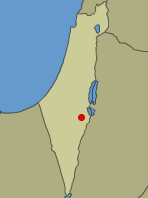
Navot the square is a flat salt flat south of the Dead Sea that slopes slowly from south to north, its area is about 25 square kilometers. The combination between the low geographical location and the open and flat topography results in an extreme climate: high heat up to fifty degrees in the summer and cold nights when the temperature drops to around zero in the winter. Annual rainfall average - about 50 mm, that is... nothing.

The natural data of the area create a unique and special habitat. The "sterile" desert of the Hver hills and the extreme topographical demarcation that separates Navot-Kacher from the surrounding area (Dead Sea + Nahal-Zin + Nahal-Araba) prevented the intrusion of foreign species and preserved its uniqueness on a global scale,
Because the area is isolated and far from human activity, it was not harmed until the twentieth century. The Jordanian residents of Banat Tzafi (Zard) were also isolated until the XNUMXs and did not adversely affect the habitat west of them.
Navot the square is a flat salt flat south of the Dead Sea that slopes slowly from south to north, its area is about 25 square kilometers. The combination between the low geographical location and the open and flat topography results in an extreme climate: high heat up to fifty degrees in the summer and cold nights when the temperature drops to around zero in the winter. Annual rainfall average - about 50 mm, that is... nothing.
The salting is bordered in the north by a dike to protect the salt ponds from floods (if anyone knows why the dike is called Caledonia? I would appreciate the information).
To the south from the cliffs of Hovar Hashon, to the east Nahal Arba, to the west Nahal Tzin. The ground base of most of the area is river alluvium, a mixture of the remains of Hvar-Lan's clay and calcareous alluvium brought by the streams.
Nahal Tzin, Nahal Ametsia, Nahal Arava and the small wadis between them drain floods that flow into the flat salt flat and irrigate it, Nahal-Arava water continues between the dams to the northern part of the Dead Sea, the flood waters in Amateia and Tzin are stopped by the Caledonia and form a seasonal puddle that attracts many waterfowl.
At the foot of the cliffs of Havar, many spring springs arise, the largest of which, Ein-Tamar (Eros), Ein-HaKar (Bida), both of them, together with many small springs, flood the salt flats with brackish water - brackish, which allow the growth of typical salinity vegetation in the growth belts that stand out between The plants are the reeds and sedges that were collected by the Druze for the purpose of mikelat, a single bell pepper that no one knew how it got there, and many Washington palms, descendants of trees planted by the "gardener of the Dead Sea factories" in the XNUMXs.
In the springs a tiny and unique species of Dead Sea sea urchin as well as crayfish. The prominent rodent representative is the pesmon which adapted to the salty environment, but with the beginning of human settlement, it is being pushed out by the rat (Nazokia), many reptiles, birds and mammals form a rich and diverse living world.
The first settlers brought a mixed herd of cows - Afrikander and Brahma. The herd that failed due to diseases, fevers and ticks was taken to the north and sold, but when the herd arrived at Naot-Kechar there were three cows (Turkish) that had escaped from their herds. These joined the large herd, when the herd was captured before it was taken out, the three "turkeys" ran away, two Brahma calves and one Afrikandar calf
These roamed the field, bred, fought, managed to overcome the feverish diseases and all those factors that caused the large herd to be eliminated, that is, a subspecies of cows was created that adapted to the difficult and special conditions of the Naot-Kachr's salinity.
The first settlers who came to Naot HaKacher in 1959, came out of love for nature, the place, the environment,... the cattle farm failed... In the meantime, date plantations were planted, a winter vegetable garden was established, and these backed up the activity of desert trips in the Negev. In the early seventies, two moshavim took the place of the first settlers. The people of the moshavim came to the place with a different ideology, something the song "We will cover with concrete and cement..." and the results for the environment were disastrous.
A wild hunt of a unique subspecies of pigs to a place where they destroyed until the last one. This was also the fate of the herd of cows, in the countries of the world it is customary to preserve subspecies of domestic animals mainly if they are suitable for their environment. When in 1968 I proposed to give protection to the unique herd of cows by declaring it a "protected species" I was met with foolish responses, when I proposed to the "authority" to declare the Navet-Kakher as a nature reserve, the Dead Sea Enterprises prevented it. At the time, I wrote that an environmental approach of the local residents by being partially engaged in preserving the environment and operating tourism in the place will save the salt.
Due to mental limitations, budget limitations, or just impotence, today we can only cry over spilled milk.
Today: the beautiful Hvar wadis are covered with trash, the little area that is still left from the salting is plowed with the marks of vehicles that have sunk into it, a little. .. because the water from the evaporation ponds flowed over the Caledonia and flooded most of the salt Naot salt - the square is one of the most beautiful areas in Israel, a unique and special area of its kind
on a global scale. Adequate salinity. . .. is gone.

One response
Zero degrees?! Are you sure about that, doctor?