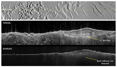
The MARSIS instrument on board the European spacecraft Mars Express began its operation and explored the South Pole

The Mars radar, MARSIS, began to observe what is happening below the surface of Mars and thus opened the third dimension for the study of the planet. The device's success, as shown by the first images it transmitted, encourages scientists to think about all the other places in the solar system where a radar device can be used. The European Space Agency, with the help of NASA scientists, managed to activate the radar in the research mission of the ice cap at the south pole of Mars.
"We were able to prove that the polar caps on Mars are mainly composed of water ice, and we created a reservoir and now we can know exactly how much water is there," said Roberto Orosi, deputy chief researcher in the Marsis project from the IASF-INAF Institute, in Italy.
No matter how accurate the camera on the satellite is, it can only map the surface of the planet. To obtain information about subsurface features, planetary scientists in the past had to land on the surface and start digging. However, this is of course suitable for the examination of a single point, and to a depth of only a few tens of centimeters.
To get a global picture of what is happening under the surface of Mars, a radar device such as Mars Advanced Radar for Subsurface and Ionosphere Sounding (MARSIS) is needed, to find the best points for landing spacecraft and digging.
"Marcis is an experiment in the full sense of the word, it is a step forward into the unknown." said Ali Safainili, a co-investigator at the Jet Propulsion Laboratory in California. "No one has yet used a radar from orbit around another planet so far, so the team can't even be sure if it will work as intended. The subsoil of the planet may be too opaque to the radar waves or the upper layer of the Martian atmosphere (ionosphere) may absorb the signals more than expected and render the device useless. Fortunately, neither of the two pessimistic predictions came to pass.
The next destination is Europe
After completing the mapping of Mars, the next step will be to send Mars-like instruments to other bodies in the solar system, and one of the obvious targets will be the fair moon Europa. "A device such as Marsis that will orbit Europe will be able to dig under the ice sheet to understand what the enigmatic contours we see on the surface are. He may also see the interface at the bottom of the ice where the ocean is expected to start.
On Saturn's moon Titan, the radar will be able to locate the depth of the hydrocarbon lakes that Cassini discovered, and it may also be possible to explain the enigmatic geysers of Enceladus using radar. "Radar instruments will be able to adapt to the study of icy planets," Orosi said. Such detectors will also be able to examine the exact shape of near-Earth asteroids and perhaps also help eradicate threatening asteroids.

One response
Israel's radar "Hawk" has been doing this for several months over the Gaza Strip and has an accurate map of all the tunnels in Gaza. Just like streets, lanes, rivers, etc.
In the next war, the IDF will kill the entrances and exits of the tunnels with tons of terrorists' bombs
The idiots of Hamas will bury themselves alive in tunnels like the last 7 were buried in the last IDF shelling
And not from a landslide as reported in the news.