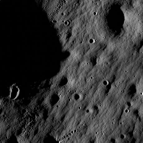
The pictures show an area that is exactly at the seam between day and night, so the rocks in it look scarier than in reality. This is for the purpose of calibrating the pair of spacecraft cameras

The Lunar Reconnaissance Orbiter (LRO) orbiting our natural satellite transmitted the first images to Earth since entering lunar orbit on June 23. The spacecraft's two cameras were activated on June 30. The cameras are working well and returned images of the mountainous area south of Lake Novarium (the lake of the clouds).
The LRO spacecraft and its pair of cameras (LROC) will gradually build a photographic map of the Moon's surface.
"Our first images were designed to be taken along the boundary line between day and night, so we couldn't know what the images would look like," said director of the LROC instrument on the LRO spacecraft Mark Robinson of the University of Arizona in Tampa. "Due to the deep shading, the fine lines of the landscape are emphasized, which gives them a rugged and uninviting look. In reality these areas are similar to those that the Apollo 16 crew safely explored in 1972. While the images are spectacular in their own right, the main message is that the LROC cameras are ready to begin the mission."
Besides the camera facility, there are six more devices on board the spacecraft. A neutron detector that will observe areas rich in hydrogen and may even have ice deposits in them; A telescope for absorbing cosmic rays to examine the effects of radiation and measure the lunar environment. Both of these devices were activated on June 19 and are functioning properly.
The devices that will be operated during the next week and include the laser altimeter designed to build three-dimensional topographical maps of the lunar surface; A radiometric experiment that will build a temperature map of the surface of the moon, and an experimental miniature radio device - that will receive radar and radio waves and search for ice on the surface, as well as create a detailed map of perpetually shadowed craters.
The last instrument - the Lyman Alpha mapping project, will be activated after the other instruments have completed the calibration, thus giving time for the residual polluting materials left over from the LRO's production and launch to be ejected into the void of space. This is an ultraviolet imaging device that will use starlight to search for ice on the surface. He will photograph the perpetually shadowed craters near the lunar poles.

5 תגובות
Concerned citizen:
In my opinion, there was reason to be concerned about the very question of "I don't understand" because many answers to it appear in the article itself.
Just for an example: we intend to prepare XNUMXD topographical maps of the moon. Why do it? Because there is none!
The same goes for all the other things.
And that those who do not understand will understand.
I don't understand - I just skimmed through the article, but it seems that they are photographing one of the poles of the moon that is not visible from the earth and probably doesn't have much material on it
That's exactly the problem... that you don't understand...
Is this the resolution that LRO takes pictures of? small, isn't it?
For 40 years we have been exploring the moon and sending spacecraft to it that take pictures of it from every possible direction, what is the uniqueness of the current photographs compared to millions of previous photographs of the moon?