NASA's Lunar Reconnaissance Orbiter known by the abbreviated name LRO allows researchers to create the most accurate and complete map of the complex and cratered landscape of the moon

NASA's Lunar Reconnaissance Orbiter known by the abbreviated name LRO allows researchers to create the most accurate and complete map of the complex and cratered landscape of the moon
"This database is used to produce a digital map of the lunar surface that will be a source for manned and robotic studies of the moon" says Dr. Gregory Newman of the Goddard Space Flight Center in Maryland. "After a year of data preparation, we already have 3 billion data points of the laser altimeter on board the LRO spacecraft in a uniform distribution of longitudes. We expect to continue making measurements at this rate over the next two years of this phase of the science mission and beyond. Near the poles, we expect to provide a navigation capability almost like that of GPS as the coverage will be compressed due to the polar orbit of the satellite."
Newman presented the map at the American Geophysical Union meeting held on December 17 in San Francisco.
The lunar eclipse laser altimeter (LOLA) works by sending laser pulses of different colors that are split into 5 laser beams. These rays strike and are reflected from the lunar surface. From the return pulse, the electronic devices on LOLA calculate the time of flight, and taking into account the speed of light provides the range from the spacecraft to the surface of the moon. Range measurements combined with precise tracking of the spacecraft's position are used to construct the map that reveals the route of the lunar surface. The five laser beams create a two-dimensional pattern and thus the configuration of the slopes can be estimated.
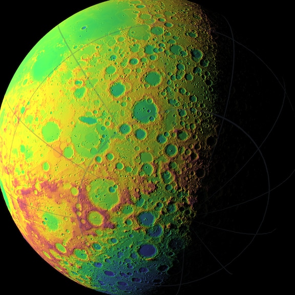
LOLA's maps are more accurate and sample more places on the surface of the Moon than any map built so far. "The positional errors in the image aggregate of the far side of the moon, where the direct measurements of the spacecraft - the most accurate - are available, were between one kilometer and 10 kilometers," says Newman, when they are reduced to a resolution of 30 meters or less in space and one meter horizontally.
At the poles, the illumination rarely provides more than hints of the topography below the crater peaks, we discovered horizontal errors of hundreds of meters” In terms of coverage, this is the collection of 3 billion points so far by LRO compared to about 8-9 million in each of the three international lunar missions. The distance between the points was one to two kilometers, with our measurements being an average distance of 57 meters from each other in 5 trackings separated by about 15 meters.
"The studies clarified some of the aspects of the processes on the moon in a much more accurate topography thanks to the new LOLA mapping." Newman said. Things such as the density of craters and the modification of the surface through impacts, as well as the formation of multi-ring basins."

8 תגובות
Aliens didn't find there? After all, there are claims that there are entire colonies of aliens on the far side of the moon from us...
Maybe they won't try to anvil but to the @#%.
What's wrong with a little Judaism, it sounds as if Chabad and Celeb offer drugs to children. It sure is better than a foreign and distant culture. I wonder what will happen when the local boys/girls start dating refugees.
At least they won't try to anvil the children, in contrast to those who want the children of Ramat Aviv to be Chabad or the residents of Ramot Shaviv to Breslav.
Mr. Blizovsky:
How about bringing some Sudanese refugees into Ramat Aviv.
The secret of the longevity of whitening
Using the spacecraft's A TRA-LOLA instrument
What will happen to the spacecraft now that it has completed its mission?
Well, how will they take property tax without good surveyors.