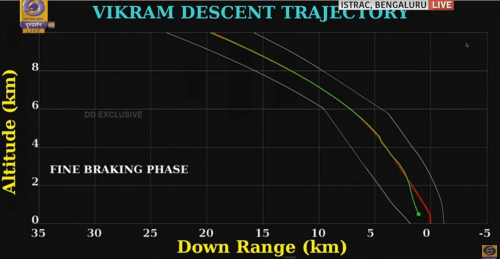
When the lander was at an altitude of 2.1 km, the green line showing its actual route suddenly began to deviate from the red line describing the planned route

Again a plan for a soft landing on the moon was shattered. This time it's the Indian Vikram lander that came out of the Chandrayaan 2 spacecraft. The nature of the malfunction was very similar to the one that caused the crash of the Israeli spacecraft in April of this year.
The Indian lunar lander Vikram failed to land on the moon as planned - and crashed from a low altitude. The official announcement has not yet been made - but the Prime Minister of India left the control room after a briefing from the head of ISRO... a few minutes before she was supposed to land, the green line showing her actual route suddenly began to deviate from the red line describing the planned route.
Indian Prime Minister Modi tweeted: "India is proud of our scientists. They gave their best and always brought pride to India. There are moments when you have to be brave, and we will be brave."
The lander was supposed to land between two craters at a distance of about 350 km from the south pole of the moon, and from the Atkins crater, where the Chandrayaan 1 spacecraft first discovered ice deposits in 2008. The discovery of water could help the manned missions that NASA is planning near the south pole in 2024 .
Chandrayaan-2 was launched six weeks ago - more than a year behind the original schedule and includes a spacecraft that will attack the moon and a lander, Vikram, inside which is a six-wheeled vehicle. The mission's main goals are to explore the hitherto unexplored region of the South Pole, and to locate water on the moon.
The landing process is carried out completely autonomously. When Vikram was found at an altitude of 35 km above the surface of the moon, its engines were activated to slow the speed of the spacecraft's descent from 6 km per second to almost zero. At an altitude of about 2,100 meters, contact with the spacecraft was lost, its horizontal and vertical speed were higher than planned, and as mentioned, the telemetry data showed a deviation from the planned route (see photo).
The autonomous landing - one of the scariest moments
The head of the Indian space agency, Kailaswadivo Sivan, said at a press conference last month that the automatic landing would be the "scariest moments" for the organization.
Chandrayaan-2 carried 13 instruments from India and one from NASA designed to collect data to more accurately measure the distance from Earth to the Moon and better understand its orbit. Of the Indian instruments, eight are orbiting the mother spacecraft that separated from the lander on September 2 and is now orbiting the moon. And as mentioned, she was supposed to release an all-terrain vehicle that was planned to travel up to a distance of 500 meters from the lander, and provide additional data. The mission of the lander and vehicle was supposed to last one lunar day - 14 Earth days.
Extension of the Mikapet mission from one year to two years
As mentioned, the Indian Space Agency will now be forced to make do with the instruments on the spacecraft, whose mission was extended from one year to two years in order to compensate for the science that was supposed to be achieved by the lander and the vehicle. Among the instruments is an imaging spectrometer in infrared light that maps the light reflected from the moon's surface in a wide range of wavelengths, with the aim of identifying the composition of the surface. The same instrument will also make the first direct measurements of volatile substances, such as hydrogen and carbon dioxide, near the poles. This will help researchers study the origin, composition and distribution of volatiles in these regions, says Ryan Watkins, a lunar scientist at the Planetary Science Institute in Tucson, Arizona.
The spacecraft also carries a radar that operates on two frequencies to locate water ice inside permanently shadowed craters, and to map the thickness and electrical conductivity of lunar rocks. This will be the first radar mapping of its kind in lunar orbit.
More of the topic in Hayadan:

4 תגובות
the moon is high up there,
so we can't lie
Aviv Gefen said
Why do I have a feeling that no man has ever landed on the moon and it's really one big lie
Lots of material for fans of conspiracies, aliens, and celestial entities involved.
so we
at that stage