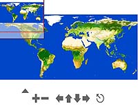
An initiative of the European Space Agency and the Food and Agriculture Organization of the United Nations presents an initial version of the GlobCover software that presents a unique view of the Earth

In the past, global mapping of the earth has already been done in different resolutions and by different bodies, but this is the first time that the map will be available to the general public. The interactive map will contain high resolution images - 10 times more than all its predecessors - and will be completed in June 2008.
Globe-Cover is based on 20 terabytes of images, equivalent to the content of 20 million books. The images were taken by the MERIS camera mounted on the European Space Agency's Envisat Earth observation satellite. The map is based on all images taken between May 2005 and April 2006. All information has been standardized by special techniques developed specifically for this purpose.
The purpose of the interactive map is to present the earth's surface coverage, for this purpose 22 different displays of surface coverage were developed, including agricultural areas, marine areas, artificial (urban) areas, permanent areas of ice or snow, forest areas, vegetation areas and more. To increase the usefulness for researchers, the legend of the map was adapted to the LCCS of the United Nations (UN Land Cover Classification System).
Globe-Cover was launched in 2005 by the European Space Agency in collaboration with international partners such as the United Nations Environment Agency (UNEP), the Joint R&D Center of the European Community (JRC), the European Environment Agency (EEA), the World Forest Mapping Organization, World Land Mapping Organization and many other bodies.
Scientists who will help with the information are eagerly awaiting the publication of the final interactive map. Beyond the visual mapping of the various areas, Globe-Cover will help analyze trends over the years, will be a tool for locating and managing resources, will help ensure food, will help monitor the effects of global warming in general and the effect on regional ecosystems in particular. The map has many uses in a variety of fields, it will be free to all, and the information in it will have a high resolution that has not been seen until today.

4 תגובות
An excellent idea that will encourage many ventures with limited abilities.
But I hope they are aware about the sensitive information such as military areas etc.
Dror, indeed the goal is to serve research on a global scale. But it can also be used in more limited studies - for example in the State of Israel it will be possible to check the percentage of the area that is used as agricultural land, forests, urban areas, etc... and then compare it to the data in one year and in five years.
Another minor note:
"10 times higher resolution" ???
This is not Google Earth!
This is mapping with a resolution of 300 meters per pixel. It will probably only be able to serve research in a global KNM.
More detailed global mappings available to scientists have already been done, but with the help of SAR from a shuttle.
Very nice!
Minor note: It's not a bit '90s' to explain to us every time there is a database size score (here: "20 terabytes of images") how many books will it occupy? Apart from the arbitrariness of the conversion (what is the volume of a book?!) it does not add much knowledge. By the way, the size is not that impressive either - smaller than the size of HOT's VOD library...