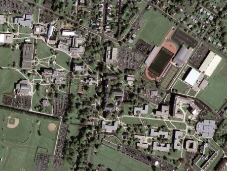
The image of Kutztown University in the state of Pennsylvania, USA is the first to launch the new GeoEye-1 commercial photography satellite, which is equipped with the highest resolution imaging systems available in commercial satellites of its type and which is operated in partnership with Google, and feeds the Google Earth service

The image of Kutztown University in the state of Pennsylvania, USA is the first to launch the new GeoEye-1 commercial photography satellite, which is equipped with the highest resolution photography systems available in commercial satellites of its type and which is operated in partnership with Google, and feeds the Google Earth service.
The satellite was launched on September 8 this year from Vandenberg Air Force Base in California. General Dynamics, the manufacturer of the satellite, says that the cost of building and launching GeoEye-1 is about half a billion dollars.
The satellite, weighing 1955 kg, photographed the site on October 7th when it passed in orbit from the North Pole to the South Pole at an altitude of about 675 km above the Earth at a speed of about 27,200 km/h. The satellite is able to provide images with a maximum separation of up to 41 cm.
whose shape is reminiscent of a dish and its size is about ninety centimeters, are returned to the secondary mirror [B] which is about thirty centimeters in size, and are transferred through the central opening to the third mirror [C] which focuses the image and transfers it to the camera [D]."]![The light rays hit the main mirror [A], which is shaped like a cake and is about ninety centimeters in size, are returned to the secondary mirror [B], which is about thirty centimeters in size, and are passed through the central opening to the third mirror [C] which focuses the image and transfers it to the camera [D]. The light rays hit the main mirror [A], which is shaped like a cake and is about ninety centimeters in size, are returned to the secondary mirror [B], which is about thirty centimeters in size, and are passed through the central opening to the third mirror [C] which focuses the image and transfers it to the camera [D].](https://www.hayadan.org.il/images/content2/space/geoeye_parts.JPG)
Google has signed an exclusivity agreement with the satellite imaging company GeoEye for the use of the GeoEye-1 satellite photos and due to legal requirements it will be forced to reduce the resolution to 50 cm per pixel, but even this resolution is better than the one used by competing services for Google Earth.
See the expansion on the GeoEye-1 satellite in the article: "The clearest view from space"

6 תגובות
Another step on the way to the space of a commercial company, and it is a welcome step
With so much focus, how can we escape from ourselves?
maybe also -
freemap.co.il will inherit the Map company and Google AR and Ofek aerial photographs
??
Will the Messiah come?
Maybe... maybe a revolution is expected in the geographic information services in about a year when they will start entering images with a resolution of half a meter for commercial use and we will start to explode with a lot of information and content surfing on services like Wikimedia and the like, we will be able to number trees in cities, distinguish a car in the parking lot in front of the house and as far as the imagination goes. Google AR will develop and develop complex editing capabilities to compete with ESRI tools. Maybe... what do you think?
Regret is a company and that is what it is
Stop the Star Wars comparisons and POPPET MASTER conspiracies
Google needs one mistake and it will fall like a meteor
You can forget about superpowers like the USA and Russia of the 20th century.
The new powers of the 21st century will be Internet powers like Google.