On this occasion, NASA announced that the landing area will be named after science fiction writer Ray Bradbury.

The Curiosity robotic all-terrain vehicle made its debut yesterday on the land of a plain named after science fiction writer Ray Bradbury, author of "Notes from Mars" who passed away recently.
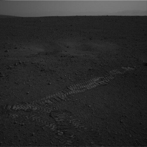
In the photo you can see Curiosity's wheel prints on the first test drive that took place on the 16th day after landing. The photo was taken by the right navigation camera of the vehicle.
Finally: Curiosity broadcasts a panoramic image of Gale Crater and Mount Sharp
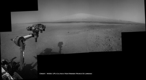
In the photo: a panoramic photo of Mount Sharp (right) and Gale crater from the Mars rover Curiosity. Eventually, the vehicle will climb the mountain, which is about 5 kilometers high, in search of minerals that contain or were formed with the help of water. The image was taken gradually by Curiosity's navigation camera during the Martian days (Sol) 5-12 of the mission
Finally, the imaginary robotic vehicle Curiosity transmitted the highest resolution panoramic images - a general view of the transform break of Mount Sharp. The mountain is surrounded by the drifts of the Gale Crater wall, where Curiosity landed seven years ago.
The robotic arm and the shadow of the camera arm are visible in the foreground of the image.
The photo was taken with the help of Curiosity's navigation camera and you can see the mountain peaks all the way to the horizon. The vehicle is about 7 kilometers from the base of Mount Sharp, which is 5.5 kilometers high - higher than most of the peaks of the Alps.
Eventually, Curiosity is supposed to climb Mount Sharp and explore it layer by layer.


5 תגובות
Moshe, let me tell you a secret... even the computer on your cell phone is more powerful than the robot's computer... but what to do? If we sent your camera and cell phone, then they wouldn't survive the journey, and the robot wouldn't be able to take pictures, and I.T. Couldn't call home...
The devices on the robot may not be advanced, but they are very reliable. They have to withstand low temperatures, high temperatures on landing, cosmic radiation and strong solar radiation, and the winds and dust of Mars...
Another "high-quality" image that "reveals a lot" from the maker of NASA. Lucky they send pictures of gray levels and not the black and white of a fax. (The camera I ordered on eBay for $4 shoots better)
The goal is not to look for water there. The area where Curiosity landed is called Gale Crater and this area was pre-selected
Because it is known that it has and had in the past a large concentration of water. By the way, the temperature there during the day is about 3 degrees and at night about
Minus 100 degrees Celsius, so the water is basically frozen.
Anyway, the area that Curiosity needs to reach in about three months is at the foot of Mount Sharp
which is at the end of Gale Crater - currently at a distance of between 6 and 7 km. This area is geologically very special because as
Going up the mountain you can see layers and sediments that occurred in the distant past of Mars. That is, it will be possible to see and examine the history of Mars up close, and perhaps even find evidence of life developing on Mars
At a time when there was still an atmosphere and temperature that allowed the existence of lakes and rivers.
By the way, just to get a proportion of the travel speed, according to what was said yesterday at the JPL conference, the travel
which was yesterday as you can see in the picture took about 5 minutes...
"Eventually, the vehicle will climb the mountain, which is about 5 kilometers high, in search of minerals that contain or were formed with the help of water"
Doesn't it make more sense to look for water in low places like slopes and valleys?
What sense is there in looking for traces of water specifically in the high peaks?
I thought water tended to concentrate in low places rather than high places.
https://www.hayadan.org.il/images/content3/2012/08/wheel-tracks1-500×500.jpg