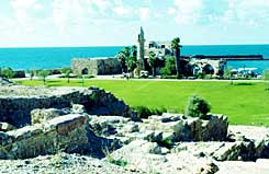
An examination of 64 wells that supplied water to ancient Caesarea shows that the sea level on the coast of Israel has hardly changed in the last 2000 years
Ran Shapira, Haaretz, voila!

2000 years of still water
One of the results of global warming is a gradual, but constant, rise in sea level. According to measurements made in the XNUMXth century, in some areas of the world the sea level is rising by about a millimeter a year and scientists fear that in the future large areas of the coast in submerged areas of the world, such as the Netherlands, will be flooded. But a study recently published by a team of scientists from the University of Haifa, the Antiquities Authority, the Center for Mapping Israel, and the University of Canberra in Australia provides reassuring information about the relatively mild trends in sea level change on the Israeli coast (but no conclusions should be drawn from it about other areas, not even in the Mediterranean).
The researchers, led by Dr. Dorit Sion from the Department of Maritime Civilizations at the University of Haifa, calculated the sea level for 19 centuries and thus greatly expanded the information about changes that took place on the coasts of the country in this area. Until this study, the data on the sea level on Israel's coasts only included information from the middle of the 19th century, when measurements of the sea level began. Dr. Sion and her colleagues collected the data from wells that were uncovered in the excavations conducted in the ancient port of Caesarea by the late Prof. Avner Raban of the University of Haifa.
The city, built by Herod in the years 10-22 BC, was continuously inhabited until it was destroyed at the end of the Crusader period, in 1265. Dr. Sion and her colleagues examined 64 wells dug during all the years of archaeological research in all of Caesarea. These wells have provided water to the city's residents since its foundation.
The archaeologists determined the time of use of each well and measured the depth of its base. The dating was based on potsherds found at the bottom of the wells and the stratigraphy (layout) in the old city. Pottery was thrown into the wells when they ceased to be used for water supply and became containers for domestic garbage.
A well should serve as a reliable source of living water even in periods when the water level is low, that is, in the summer season, or in years with little precipitation. According to Dr. Sion, a well close to the coast is dug up to a layer of fresh groundwater, under which there is a layer of salt water. The diggers of the wells had to make sure that a layer of fresh water was preserved in them even in the summer, when the groundwater level drops.
The researchers believe that in order for a well to meet these requirements, the depth of the potable water in it should be, in any condition, 40-30 centimeters. Based on this determination, they could estimate the minimum water level during the period when the wells were in use.
In order for these data to make it possible to estimate the sea level at that time, it is necessary to understand the relationship between the water level in the wells in Caesarea and the sea level today. From thorough tests of the fluctuations in the level of the groundwater in one of the wells, and from their comparison with the fluctuations of the sea level in the same period of time, the researchers concluded that there is a correspondence between the fluctuations in the groundwater and the fluctuations in the sea level. According to the measurements, the water level in the well is up to about 80 centimeters above sea level, and this difference is maintained throughout the period of activity of the well. The measurements in the well were conducted using a digital tide gauge, provided by the Israel Mapping Center.
The data on the relationship between the groundwater level and the sea level today was the key to reconstructing the sea level in the past. According to the depth of the base of the wells, the minimum water level that was required in the past for them to function well was estimated, and from this the approximate sea level height at that time was calculated.
In an article recently published in the journal "PlanetarySciences Letters Earth and" the researchers write that measuring the depth of the base of the wells made it possible to reconstruct the sea level in the past, and hence its reconstruction in historical periods - from the first century AD to the middle of the 13th century AD. From here they deduced the following centuries. In general, the sea level was relatively stable in the last 19 centuries - until the twentieth century - with slight fluctuations of about 40-30 cm above and below the current level in different periods.
Contrary to this, in the last century measurements from all over the world showed that the sea level is gradually rising. From the data from the wells in Caesarea it becomes clear that the rise in sea level in the 20th century is an unusual and relatively new phenomenon. It remains to be seen how new this phenomenon is.
