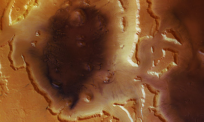
The Mars Express spacecraft photographed a large area on Mars that appears to have been shaped by flowing water

This amazing photo, taken from the Mars Express spacecraft of the European Space Agency (ESA), shows us the 'Deuteronilus Mensae' region on the planet Mars, an area shaped by glaciers that melted millions of years ago.
The photograph was taken using the High Resolution Stereoscopic Camera (HRSC), on March 14, 2005 during lap number 1483 of the Mars Express spacecraft, when the resolution of the ground surface of Mars in this photograph is 29 meters per pixel.
The depth of the huge hole in the center of the picture reaches approximately 2 km and it extends for 110 km. Most of the valleys were formed because of a strong mudflow that weakened in the area. Researchers believe that these valleys were formed because of ice that slowly melted and created a flood of mud. This water quickly froze and turned into glaciers that washed down the mountains.
Even so, the area is cold and lifeless, but it also shows us that Mars was once very active geologically, so it is believed that as a result of a magma rise (molten rocky material), or a similar chain of events could melt a vast area of ice into a giant mud flood.

2 תגובות
The water dried up
What happened to the glaciers? Where did the water go?
Are there any answers about this today?