managed to reach a recognition level of 97%
The Technion researchers, in collaboration with the Geological Institute, developed a model for the automatic detection of sinkholes and other environmental phenomena along the shores of the Dead Sea that demonstrated detection capabilities at a high level of reliability, over large areas, and in complex terrain features.
"The drastic drop in the level of the Dead Sea leads to a series of geomorphological processes that have a significant impact on infrastructure and the environment as part of the natural system's response to the drop in level," explains Dr. Shagia Filin, a faculty member in the Mapping and Geo-Information track at the Technion's Faculty of Civil and Environmental Engineering. "The formation of sinkhole fields in the Dead Sea region is only part of the variety of phenomena that directly result from the drop in the lake level, which has reached a rate of about one meter per year in the last ten years. Due to the impact of the sinkhole fields on existing and planned projects and on regional development in general, identifying and characterizing such phenomena in the initial stage of their appearance as well as predicting their progress becomes necessary."
For this purpose, during the last year, a feasibility study was carried out to identify sinkholes as well as phenomena that indicate a change in the surroundings with the help of aerial laser scans. The research was carried out by Dr. Sagi Filin and Mr. Amit Baruch from the Technion and Dr. Yoav Avni and the sinkhole project staff at the Geological Institute.
The airborne laser systems (LiDAR) have been shaping the approach to XNUMXD mapping and data processing in recent years. Their ability to directly provide a dense and accurate XNUMXD "cloud of points" opens up a wide range of options in any field related to XNUMXD mapping. The principle of operation of most laser systems is based on direct range measurement, from the system to the object, with the help of sending a concentrated "energy pulse" and measuring the time that passes until it returns. The accuracy of the range measurement in aerial systems basically allows for height determination with an accuracy of a few centimeters. To determine the location of the individual where the beam hit the ground, the laser system is combined with a GPS system
(Global Positioning Systems) and an inertial navigation system
(Inertial Navigation Systems - INS) which allows determining the position and tilt angles of the beam. The integration of the information from the three systems enables the translation of the measured range into national coordinates. In order to achieve spatial coverage of the area, the systems operate in a scanning mode in which the launched laser beam is deflected in different directions, so that during a flight over a certain area, the system scans an entire strip of the area below it. The ground coverage, as well as the information density, are affected by the system characteristics and the flight altitude. A higher flight rom will allow a wider spatial coverage (as a function of the maximum opening angle of the scanning system), but the data density will be relatively low, since the angular differences between "pulse" and "pulse" will translate into a greater ground distance. In order to achieve coverage with a high data density, the scanning rate has increased in recent years by significant orders of magnitude, up to about 100,000 "pulses" per second, so that a high scanning density will be possible even at a high flight speed. The principle of measuring the reflected energy, leads to another important feature of the laser systems, which is their ability to penetrate vegetation. Since some of the photons will penetrate the vegetation canopy and be reflected from the ground, it is possible to measure from one launched "pulse" both the reflections from the vegetation canopy and the reflections from the ground. This feature makes it possible to obtain the "image" of the relief and cover directly from a single scan.
The main contribution of the laser systems is their ability to provide directly and without human intervention a dense and highly accurate "point cloud" (height information) that covers large areas. These and other features make the aerial laser systems a tool with enormous potential in the field of three-dimensional mapping. In the fields of mapping, laser systems are mainly relevant for applications such as the production of digital elevation models, urban mapping and the identification and accurate reconstruction of the shape of buildings, and in fields that deviate from the classical mapping topics, it allows the estimation of vegetation volume, analyzes based on relief changes (for example, for changing the mass of glaciers) or three-dimensional mapping Fast after natural disasters in large areas.
The wealth of information provided by the LiDAR systems enables a detailed description with high precision, but the mass of information acquired and the density of the information make manual processing difficult and require autonomous processing models. Unlike the standard development directions that focus on prominent details (for example - buildings or vegetation) the nature of the sinkholes and the details surrounding them requires a focus on subtle details that are not usually addressed. Therefore, the work required the construction of spatial models based on the characterization of the phenomena within the XNUMXD "cloud of points" and led to the opening of an automatic model for identifying subtle geomorphological phenomena from laser data, focusing on sinkhole formation phenomena.
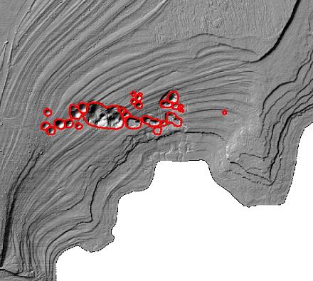
"The developed model makes it possible to effectively and reliably locate geomorphological phenomena and monitor their development," says Dr. Filin. "Running the model on scan data in selected areas along the shores of the Dead Sea showed that about 97% of the existing sinkholes in the study area, some with a diameter of one meter or less, were automatically identified from the aerial scans and the incorrect identification amounted to only 4%."
In the practical aspect, it will be possible to generalize a model to operate on areas where there are geomorphological phenomena that have a significant impact on infrastructure and the environment. Identifying and characterizing these phenomena with the expansion of the ability to predict the direction of the spread of the phenomenon will lead to more informed decisions such as banning construction in areas facing collapse, strengthening infrastructure in areas where there is infrastructure that will be damaged, or strengthening infrastructure in areas where there is infrastructure that will be damaged.
In the photo: In the photo: a topographic shading map of the laser data describing a sinkhole field in the Mineral Beach area of the Dead Sea. The lines crossing the picture are level lines created with the retreat of the lake.

5 תגובות
Another reason :
for cutting a water canal, from the Mediterranean Sea, to the Dead Sea (different from the canal plan in the north), with the consequences of the possibility of generating electrical energy, due to the height differences: the Mediterranean Sea and the Dead Sea; Also several lakes for tourism and fishing, and jobs for the residents of the Negev.
I understood that they identify the sinkholes by the changes on the surface. Can be according to flow directions and catchment basins of water that indicate what is happening below the surface. And also comparisons between measurements that indicate land subsidence. (They really didn't expand on the subject). That's why if you don't see anything on the surface, you don't know what's going on underneath.
On the other hand, it is possible to record any movement on the surface even if it is masked against optical or thermal means of vision. or done at intervals.
Not that I understand, but is it possible to use this method to map the "nature reserves" in Lebanon, or identify tunnels in Gaza?