A position paper written for the Fisher Institute for Strategic Air and Space Research * This position paper is published on the science website before its official publication: the article will be published by the Fisher Institute and also appear in "Systems"
Amber dew
Secrets for sale: Strategic aspects of Commercial Remote-Sensing Satellites
Direct link to this page: https://www.hayadan.org.il/talinbar090205.html
The views in this position paper, which was written specifically for the Fisher Institute for Strategic Air and Space Research, are those of the author, and do not necessarily represent an official position of the Fisher Institute, or the position of any institutional body.
In this article, I will review the field of remote sensing (Remote Sensing) of commercial satellites, and I will present the strategic context of the acquisition of satellite intelligence capability by various countries, while relying on commercial satellites that provide their services for money, to anyone who requires it.
I will discuss the technological progress of commercial satellites - which is approaching the capabilities of military spy satellites - and the challenges that this progress poses to the captains of various countries, including the US and Israel.
I will examine the military applications that can be derived from commercial satellites, and I will point out trends and lines of thought that should be adopted, in preparation for dealing with hostile countries that will use commercial satellites for military purposes, and I will also point out the danger of using intelligence information from commercial satellites by various terrorist organizations.
I will propose different courses of action that can be taken in order to reduce the dangers from commercial satellites on the one hand, and on the design of an advanced space concept in the view of national security, which will include passive and active components to deal with hostile countries that use commercial satellite information for war purposes and committing acts of terrorism.
This position paper only briefly presents a broad field, and it is hoped that it will be possible to expand it into an inclusive and comprehensive study.
Remote sensing using satellites was, until recently, the exclusive domain of superpowers, chief among them the United States. Starting in the XNUMXs, other countries acquired capabilities in the field of remote sensing satellites, when France was the first to set up a commercial service of a photography satellite in the visible light field - the "SPOT" and through the company "Spot-Image" made the accessibility of satellite photographs of the Earth At the disposal of many parties, who before could only dream of such capabilities.
Although the original uses for which the "Spot" satellite was intended were research in nature, its ability to cover very large areas of the earth and photograph them with reasonable resolution at the time of its operation (10 meters in the first "Spot" satellites) also appealed to various countries, which lacked the ability to access their own intelligence satellites, And they could afford the relatively low cost of purchasing images from the French satellite. Other countries even reached agreements with the French company and set up reception and image processing stations on their territory for the images taken by the satellite.
Commercial remote sensing satellites - existing capabilities
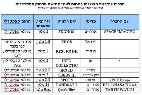
In the commercial remote sensing satellite market, several commercial companies operate from the USA, Russia, France, China, Japan, India and Israel. It is expected that in the coming years several more countries will be added to this growing market.
In parallel with the increase in the number of "players" in this market, the technical quality of the satellites is improving, and it currently reaches a resolution of one meter, and even slightly below that (for example, in the American commercial satellite "IKONOS"). It should be noted that the main activity in commercial photography satellites is For photography in the visible light range, however, some satellites are capable of providing photographs in additional wavelengths, such as infrared and ultraviolet. Satellites that produce synthetic radar imaging of ground targets (SAR) exist, and their capabilities will improve significantly in the near future.
It should be noted that various technological means are capable of refining the images received from the satellites listed in the table, and significantly improving the quality and sharpness of the image, and even preparing various products such as stereoscopic images, three-dimensional simulations of the area (they can be viewed on the computer, or even fed into a system of reality imaginary).
Many commercial companies provide image quality enhancement services from commercial satellites, and are able to provide a variety of products to the client - including mapping according to any required levy, comparison of photographs taken with time differences, measurements of ground objects, analysis of satellite photographs, and more.
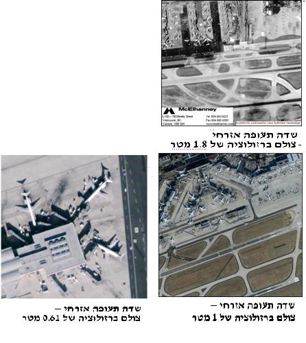
The three photographs above graphically present the capabilities (without computerized image quality enhancement) of three commercial satellites. A terrorist organization can use these photos to do excellent intelligence work in preparation for sabotage at airports, or any other facility.
Military uses for commercial satellites
Due to the high quality of satellite photographs that can be obtained by almost any entity, and at a relatively low cost, and due to the fact that commercial companies are able to improve and upgrade the products of the commercial observation satellites and bring them to an excellent resolution, the distinction between military intelligence satellites and civilian satellites is becoming obsolete and unnecessary.
Suffice it to say that the quality of civilian remote sensing satellites exceeds the quality of military satellites of various countries, which were only a few years ago at the forefront of technology.
The range of options available to a country that wants to make military use of commercial satellites is almost unlimited - from gathering general intelligence on various facilities, through the evaluation and analysis of specific structures, to the creation of three-dimensional computer models that can be used to guide guided weapons (such as cruise missiles) to the training of military forces / Terrorist organizations carrying out various sabotage missions.
As an example, we can mention intelligence gathering on targets that beckon to terrorist organizations, and whose ground photography can be a problem - such as airports, nuclear reactors, chemical plants, military facilities and civilian infrastructure facilities - such as power plants, water treatment facilities, etc. Using commercial satellites today it is possible to collect intelligence of excellent quality, and apply it in a variety of scenarios.
Preventing and limiting access to commercial satellites
Preventing hostile parties - states and terrorist organizations - from commercial satellites and the services provided by commercial companies is an extremely difficult, if not impossible, task. The multitude of countries operating commercial satellites for remote sensing on the one hand, the relatively low amounts for the final products of the satellites, and the ease with which different companies and organizations can be established to cover the real customer of the products - make restricting access a possibility that exists only theoretically.
Limiting the resolution of commercial satellites through legislation and supervision
One of the ways to deal with the improvement in the quality of commercial photographs and the dangers of these photographs being in the hands of hostile parties, is a limitation in legislation, which artificially reduces the quality of the satellite product provided to any customer. An example of this activity is the Kyl-Bingaman law, enacted by the American Congress in 1997, which limits the resolution of American commercial satellites photographing Israel to the resolution common in the world at a given time. Today the limit is 2 meters. (It should be noted that this restriction also enables the production of excellent quality intelligence, and this restriction does not apply to non-American companies). Soon the limit will be eased and a resolution of one meter will be applied - due to Russia's progress in developing a commercial photography satellite capable of taking pictures with a resolution of one meter.
Preventing the use of commercial satellites by hostile parties
In addition to the legislation, which is a temporary and partial solution - as it is currently applicable only to American satellites - one can think of a series of measures to limit access to commercial satellites by various parties:
• Establishing an international inspection regime to limit the capabilities of commercial satellites and those who use them, such as an inspection regime to limit the sale of missile technologies (MTCR)
• Increasing the supervision of the companies that market the satellite products on their customers;
• Acquisition of the ability to disrupt the connection between the commercial satellites and their ground stations - an action that can be carried out by a variety of means and the integration of armed forces;
• Acquiring the ability to disrupt the sensors of the commercial satellites as they pass over various targets - for example, laser glare;
• Acquiring the ability to intercept and damage satellites - by lasers, anti-satellite missiles or other weapons (a problematic aspect, in violation of the International Convention for the Prevention of Armament of Space);
• Acquiring the ability to hit and neutralize ground receiving stations - by aerial action, ballistic missiles (PGM) or special forces;
It is understood that some of the options for preventing and disrupting the operation of commercial satellites are not possible in peacetime, and some are limited even during an armed conflict.
The captains of the defense system must put their hearts to the fact that the intelligence capabilities of the conflict countries and terrorist organizations have made a real "leap", and that the power relations of the State of Israel as having an independent space intelligence capability, in the face of hostile countries that lack this capability, are more inclined towards balance - since conflicting countries can acquire satellite intelligence capability commercially - even if with certain limitations of the quality of the products, and the relatively long period of time to obtain the finished intelligence product.
Along with the severe limitations faced by a country wishing to prevent a hostile country from accessing space intelligence, there remains the need to develop and perfect the intelligence capacity of a country like Israel, in order to further increase the gap between it and conflicting countries that rely solely on commercially obtained intelligence. Increasing the gap also has a deterrent aspect, demonstrating Israel's technological superiority over its neighbors.
From the above, several main conclusions emerge:
• The ever-increasing access to satellite intelligence, the quality of which is constantly improving, changes the balance of power between a country with an independent satellite capability and a country or organization that lacks such capability. Countries lacking self-satellite capability now enjoy capabilities that were until recently the property of superpowers. This approach will inevitably lead to perceptual changes at the level of the country's captains, as well as increasing uses of the observation products from space by the private and business sectors in the country. In addition, access to observation products from space can lead to internal changes in certain countries, which have limited access to information from the public.
• Commercial remote sensing satellites can be used for both positive and negative applications. Among the positive aspects - reducing the ability to commit mass massacres (for example, the former Yugoslavia), effective management of humanitarian crises, prevention of deterioration in crises of a military nature between countries. Negative uses can be gathering intelligence to carry out acts of terrorism and attack, industrial espionage, or aid in the conduct of wars.
• Attempts to limit the capabilities of commercial satellites through legislation or international treaties are expected to fail in the long term. The multitude of players in the commercial satellite market, and the conflict of interests between them, undermines the assumption that it will be possible to reach enforceable international agreements, regarding the limitation of commercial satellite capabilities or the prevention of use by hostile parties.
• Increasing the capabilities of the commercial satellites will cause the development of more and more sophisticated means of deception and concealment. It is also possible to expect the development of a variety of new weapons aimed at satellites. The countries that develop nuclear weapons, for example, will choose to develop sophisticated concealment capabilities, and will prefer underground construction. At the same time, countries can develop offensive systems to prevent their territory from being photographed - capabilities that can operate into space, in space or on the ground.
Undoubtedly, the commercial satellites for remote sensing require deep thinking and refreshing accepted conventions in the field of national security and international relations.
The superiority of the superpowers, and a handful of advanced countries, over most of the world's countries, in the field of remote sensing, is greatly eroded, and has almost disappeared (of course, the US has excellent military capabilities in the field of remote sensing, but most of the world's countries have no real need for this capability, and the commercial satellites "provide the the goods" in a satisfactory way, and even more so).
The ability to see what is happening on the territory of the other, to analyze the information and to make diverse uses of it - military, political, social and media - requires a perceptual adaptability on the part of the countries of the "first generation" of remote sensing satellites, and not just preventive technological adaptation (passive and active).
Implications for Israel and recommendations
The Kiel-Bingaman Amendment has been used since its enactment as a barrier that does not allow countries in conflict to obtain intelligence information at the highest possible resolution by commercial collection satellites from the US. However, the advancement of technology in other countries, such as Russia, is constantly lowering the resolution available on the international market of collection satellites operating on a commercial basis, so that the protection of the Kill-Bingaman correction is gradually eroding.
With the appearance of non-American commercial satellites with a resolution lower than one meter, a gate will be opened for conflicting countries to obtain up-to-date and good satellite intelligence of Israel also from American satellites. Israel must strive to close the loophole, by updating legislation in the US and reaching an agreement with countries that operate commercial collection satellites.
At the same time, Israel would do well to examine, if only from a conceptual point of view, the ways to achieve a space deterrence capability - both permanently (total neutralization of collection satellites) and occasionally, which does not cause irreversible damage to the satellite.
Israel's ability to prevent satellite intelligence collection can be achieved, among other things, by disrupting the signal to and from the satellite, or blinding its sensors in various ways, including the use of a laser (in the case of a collection satellite in the optical field) and other means in the case of radar satellites.
The legal consequences of physical damage to commercial satellites are major, and Israel must assess for a future in which damage - temporary or permanent - to the space assets of foreign countries will become a necessity. The issue of Israel's attitude to the Outer Space Treaty, which drives the UN's activity to prevent the proliferation of weapons in space, should also be thoroughly examined.
Improving Israel's satellite collection capabilities is an essential step in establishing the supremacy of the State of Israel in the field of space - not only in the Middle East aspect, but especially to strengthen its position vis-à-vis the United States - which has announced that it considers the establishment of absolute supremacy in space its strategic goal.
An Israeli bargaining position vis-a-vis the US, regarding the continuation of the restrictions applicable to American commercial satellites to photograph Israel, and perhaps even their extension to foreign companies outside the US would be much better, if presented from the point of view of Israeli independence in space - for all its components - satellite and launch system - from An understanding that peer countries will cooperate with each other out of shared interests and out of recognition of Israel's technological capabilities in the field of space. Maintaining a quality gap in the field of collection satellites is an essential necessity not against satellites of Iran, Egypt and Saudi Arabia, but against commercial satellites of countries such as Russia, China and India, and perhaps even against American space companies. A quality gap vis-à-vis the capabilities of the space powers will emphasize Israel's position as an important player in the global satellite market, and will allow it a margin of action for at least the next decade, while establishing its position in other areas of space, such as the aerial launch of satellites, the development of micro and nanosatellites, and the acquisition of initial capabilities of Space warfare, taking into account various geo-strategic aspects and considering the deepening of space cooperation with the US, from a position of strength.
To the three appendices to this article: Ikonos satellites, satellite orbits and SAR satellites
They knew the satellites
https://www.hayadan.org.il/BuildaGate4/general2/data_card.php?Cat=~~~1799611~~~212&SiteName=hayadan
