Amber dew
In the picture: in the middle: the Iconos satellite. Below: Illustration of a low orbit (LEO) satellite, elliptical. The closest point to the Earth in this orbit is called "Phyregia" and the farthest point - "Apogee"
Direct link to this page: https://www.hayadan.org.il/inbar090205nispah.html
Appendix A: The "Ikonos" remote sensing satellite (IKONOS)
The "Ikonos" remote sensing satellite is a landmark in the history of commercial remote sensing satellites, as it is the first commercial satellite that allows ground photography with a resolution of one meter.
The satellite, which was launched in September 1999, was built by the "Lockheed-Martin" corporation, launched into space on an "Athena" type launcher (also made by Lockheed-Martin) and operated by the American company SPACE IMAGING, and provides black and white photographs of the Earth with a resolution of one meter, and multispectral photography (red, blue, green and near infrared) - which allows the creation of color photographs - with a resolution of 4 meters.
The Ikonos satellite orbits the Earth in a polar orbit (Polar Orbit), that is, an orbit that passes over the Earth's poles. This orbit allows the satellite to optimally cover the earth, since there is no need to change its orbit to photograph different places on the earth - it rotates around its axis under the watchful eye of the satellite.
The scanning width of the satellite is 13 km, and it can produce a "strip" of 11x100 km and up to 11x1000 km when it passes over the requested photo area.
Spacing between suits above the same point:
• 2.9 days for a meter resolution;
• 1.5 days for a resolution of one and a half meters;
• Shorter suit intervals for targets relatively close to the poles (rare)
The time of one revolution of the earth - 98 minutes.
The website of SPACE IMAGING - the operator of the satellite
Appendix B - satellite orbits
The commercial photography satellites are usually in one of two orbits - low orbit
(LEO - Low Earth Orbit), which can be circular or elliptical, and a polar orbit, passing over the Earth's poles. For the most part, low orbits are at an altitude of 300 to 1000 km above the earth.
A polar orbit has a considerable advantage - due to the fact that the satellite is constantly in its orbit, and the Earth spins on its axis below it. The disadvantage is the need to launch such a satellite from a relatively limited number of launch sites. The "Ikonos" and "Spot" satellites are in polar orbit.
Other satellites, including the Israeli-made "Eros" satellite, as well as the Israeli "Ophek" satellites orbit the Earth in a low, elliptical orbit, which causes the period of time for a spacecraft to return over a certain point to be longer than a satellite operating from a polar orbit.
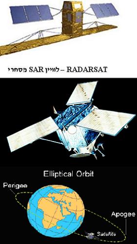
Appendix C - SAR satellites
SAR satellites are satellites that include a radar system, whose role is to produce surface imaging. While the ground radar has a large antenna (the ratio between the key and the wavelength determines the maximum resolution that can be achieved) that can in some cases reach a length of hundreds of meters, you SAR has a synthetic key - that is, the use of a small antenna that is in motion, to simulate a much larger antenna.
A satellite is an ideal platform for this technology - its enormous speed - 7 to 8 km per second - equivalent to an antenna of a similar length - allows to achieve a resolution of tens of centimeters, independent of the weather on Earth, and of course with the possibility of operating at night, and penetrating through smoke masking.
There are several SAR satellites on the commercial market, whose resolution ranges from 3 meters to 300 meters, depending on the required image quality. Photographs produced by radar can also be greatly refined and improved.
https://www.hayadan.org.il/BuildaGate4/general2/data_card.php?Cat=~~~1799798~~~212&SiteName=hayadan
