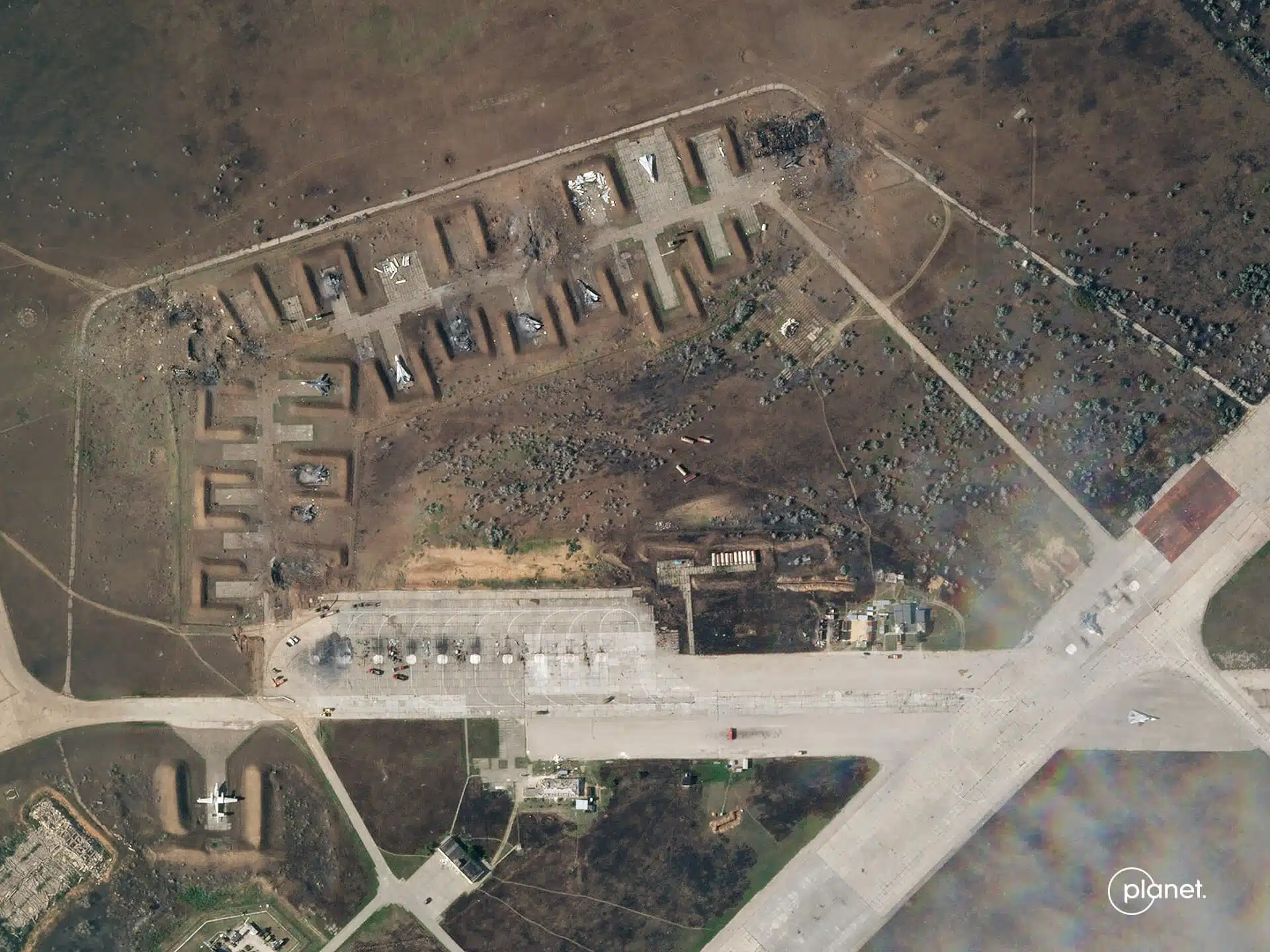
Shortly after the outbreak of the war, Ukraine, funded by the US government, requested data from private satellite companies around the world. By the end of April, Ukraine received images from American companies minutes after the data was collected. Recently, these photographs were proof of Ukraine's success in blowing up an airport in Crimea with its state-of-the-art fighter jets
By Mariel Borowitz, Associate Professor of International Relations, Georgia Institute of Technology
Satellites owned by private companies played an unexpectedly important role in the war in Ukraine. For example, in early August 2022, images from the private satellite company Planet Labs showed that a recent attack on a Russian military base in Crimea caused more damage than Russia claimed in the media. Ukrainian President Volodymyr Zelensky emphasized the Russian losses as evidence of Ukraine's progress in the war.
Shortly after the outbreak of war, Ukraine requested data from private satellite companies around the world. By the end of April, Ukraine received images from American companies minutes after the data was collected.
My research focuses on international cooperation in satellite Earth observations, including the role of the private sector. While experts have long known that satellite imagery is useful during conflict, the war in Ukraine has shown that commercial satellite data can make a big difference—informing both military planners and public opinion about the war. Based on the strategic value of commercial satellite imagery during this war, I believe it is likely that more countries will invest in private satellite companies.
Growth of the commercial satellite sector
Remote sensing satellites orbit the Earth and collect images, radio signals and many other types of data. The technology was originally developed by governments for military reconnaissance, weather forecasting and environmental monitoring. But over the past two decades, commercial activity in this area has grown rapidly - especially in the US. The number of commercial Earth observation satellites has increased from 11 in 2006 to more than 500 in 2022, about 350 of which belong to American companies.
The first commercial satellite remote sensing companies worked closely with the military from the beginning, but many of the newer entrants did not develop their technology with national security applications in mind. Planet Labs, an American company that played a large role in the Ukrainian conflict, describes its customers as those engaged in "agricultural, government and commercial mapping", and it hopes to expand into "insurance, commodities and finance". Speyer, another American company, originally focused on weather monitoring and tracking commercial marine activity. However, when the US government set up pilot programs in 2016 to assess the value of the data these companies collect, many of the companies welcomed this new source of revenue.
The value of commercial data to national security
The US government has its own network of spy satellites, so partnerships with private companies may come as a surprise, but there are obvious reasons why the US government benefits from these arrangements.
The first is the simple fact that purchasing commercial data allows the government to see more locations on Earth more frequently. In some cases, data is now available quickly enough to enable real-time decisions on the battlefield.
The second reason is related to data sharing methods. Sharing data from spy satellites requires officials to go through a complex classification process, and is also a risk factor for revealing information about classified satellite capabilities. None of these problems apply to private company data. This aspect makes it easier for the military to share satellite information within the US government, as well as with US allies. This advantage proved to be a key factor in the war in Ukraine.
Use of satellite data in Ukraine
Commercial satellite imagery proved critical to this war in two ways. First, it is a communication tool that allows the public to watch the progress of the war in incredible detail, and secondly, it is a source of important information that helps the Ukrainian military plan daily operations.
Even before the outbreak of war in February 2022, the US government actively encouraged commercial satellite companies to share their images and raise awareness of Russian activity. Commercial companies released photos showing Russian troops gathering near the Ukrainian border, directly contradicting Russia's statements.
In early March 2022, the Deputy Prime Minister of Ukraine, Mykhailo Fedorov, asked eight commercial satellite companies for access to their data. In his application he said that this may be the first major war in which commercial satellite imagery will play a significant role. Some companies agreed, and during the first two weeks of the conflict, the Ukrainian government received data covering more than 40 million square kilometers of the war zone.
The US government has significantly increased the purchases of images that can be supplied to Ukraine. The US government has also actively fostered direct ties between US companies and Ukrainian intelligence analysts, helping to promote the flow of information.
A recent example of the value of these images comes again from Planet Labs. In recent weeks, the company published photos showing the conflict getting dangerously close to the Zaporizhia nuclear power plant. In recent days, UN officials have said that the situation poses a "very real risk of a nuclear disaster" and pushed to allow UN experts to visit the site.
Before the war, Ukrainian officials thought that it was better to spend money on "earthly" security needs, rather than on expensive satellites. But now, these officials see the satellite images as critical — both for battlefield awareness and for documenting atrocities allegedly committed by Russian soldiers.
Some space experts called the war in Ukraine the first "commercial space war". The conflict clearly demonstrated the national security value of commercial satellite imagery, the ability of commercial satellite imagery to promote transparency, and not only the importance of national space power, but also allied space capabilities.
I believe that the fact that the US commercial sector has had such a significant influence on military operations and public opinion will lead to increased government investment in the private satellite sector around the world. Leaders in Ukraine intend to invest in domestic satellite imaging capabilities, and the US has expanded its commercial purchases. This expansion may present new challenges if abundant satellite imagery becomes available to players on both sides of the conflict in the future.
Several Earth-watching satellite companies have expressed hope that the lessons learned will extend beyond war and national security. The ability to quickly produce images and analyzes can be used to monitor agricultural trends or provide insight into illegal mining operations.
The war in Ukraine may well turn out to be a major turning point both for global transparency in the conflict and for the commercial sector engaged in watching the planet as a whole.
For an article in The Conversation
More of the topic in Hayadan:

2 תגובות
Is Ukraine's success in receiving reliable information from American satellite companies not related to the fact that Ukraine is currently the world darling in the war with the evil Russians?
Would the Russians have succeeded in acquiring information from that source (American satellite companies) if they had wanted to?
Will we, for example, be able to acquire such information from such companies during a crisis? Or will it be subject to the goodwill of the owners of the companies and the American government? And if such a company is, for example, owned by the equivalents of Ben & Jerry's, two pro-Palestinian progressive brainwashers who claim to have Jewish heritage, what will happen then?
In short, the launch of the next Horizons should be expedited, and perhaps even the establishment of Israeli companies for satellite photography should be encouraged. The strategic benefits may be significant.
I have a little trouble understanding why the conclusion of the study is that countries should invest in commercial satellite companies.
I agree with the statement that access to satellite data is of great significance to any country, therefore I would expect the country to invest in creating a satellite array as extensive as possible that is under its control and responsibility.
Creating dependence on commercial companies is not necessarily healthy for times of war.
And the same limitations that the study points out, regarding bureaucratic difficulties in sharing the information from the satellites, are also solvable. At the end of the day it is only a decision of the mother country and what information to share, and with whom.
States can certainly cooperate with civil companies, most of the time it is certainly helpful, but they should not depend on the willingness of those companies to provide the information when needed, because the interests or worldviews will not always align between the state and those private companies