In the last ten years we have entered the third era in the exploration of Mars - visiting robots on its surface. Geological observation of Mars reveals a history very similar to the one that existed on Earth. Part One
P. Christensen, Scientific American
Many go to the desert because of its aridity and simplicity, but I go to it because of its complexity. The rocks in western Arizona, where I work, reveal one of the most complicated stories in Earth history. Layers of carbonate limestone (carbonates), petrified alluvial soil, sand made of quartz and solidified lava, show that in the last 600 million years this area was a shallow and warm sea, then a murky swamp, a vast desert of sparkling dunes, an ice sheet and again a sea shallow.
Erupting volcanoes created islands the size of Japan which were then pushed 160 km into the continent along huge fault lines. In the process, the rock layers were tilted on their sides, heated up and produced marble and quartzite rocks. And finally the uplift and weathering processes came and made the area the desert we see today.
The third era
Such a detailed historical reconstruction of the history of Mars has so far been impossible. In my lifetime the Red Planet has transformed from a dot in the night sky into a land of towering volcanoes, sharp river gorges, ancient lakes and windswept lava plains. Clearly, the history of Mars is one of the most fascinating stories in the Solar System, but until now scientists have only been able to paint it in rough lines. For years we debated comprehensive questions such as whether Mars was once "hot and wet" like the Earth or "cold and dry" like our barren moon - as if the history of an entire world could be summed up in two words.
However, in the last ten years we have entered the third era in the study of Mars. The first two eras were the era of telescopic observations of the 19th century and the era of initial survey by the spacecraft of the 60s and 70s. The new spacecraft orbiting Mars and those that landed on its surface made it possible to map the topography of the planet, determine its mineralogy, photograph the surface and merge the data collected in orbit with the truth data of the surface. Mars has finally become a place that I can explore in the same way that geologists work, using the rocks on its surface, the minerals and the landscape formations to weave a story. And what we found shows that the history of Mars is interspersed with an impressive variety of different processes and conditions. We are beginning to understand that Mars has seen intense dryness, complete wetness and a thin layer of snow and ice. Simple definitions are no longer adequate to describe it. Instead of saying "hot" or "cold" we ask: how hot? how wet for how long? where? And the answers that emerge point to the reason why many of us study the Red Planet: on Mars, conditions exist, or existed in the past, that allow life to exist.
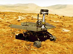
Two sites, two points of view
In January 2004, the American space agency (NASA) landed two devices, one of the most complex ever built, at two very different sites on Mars. The off-road vehicles, Spirit and Opportunity, loaded with cameras and spectrometers, set out to answer the central question in the geology of Mars: What was the role of water? Spirit jumped and landed in Gusev Crater. The crater was chosen for landing because of its shape: images taken from orbit in space have long shown that a wide channel, called Ma'adim Vallis, spills into the Gosev crater and suggests that it was once a lake.
At first the crater was a little disappointing because Spirit found no signs of water in its past but volcanic rocks. The spectrometers showed that the rocks are composed of the minerals olivine and pyroxene, minerals that would disintegrate if exposed to even tiny amounts of liquid water. It is therefore impossible for the rocks to have seen a significant amount of water in the last three billion years since the volcanic eruption that created them. But, as Spirit raced up the Columbia hills overlooking the landing site, things got more interesting. Spirit found there an abundance of salts containing sulphur.
There is no doubt therefore that the volcanic rocks were crushed into fine grains which were then glued together using salt that was used as cement. Perhaps liquid water that seeped through the rocks, or perhaps sulfuric acid that reacted with the minerals already found in them, participated in this process. Despite this hint of water, the rocks contain considerable amounts of olivine and pyroxene. Therefore, even at the bottom of an apparent lake, it seems that the role of water in the last billions of years was only secondary.
Opportunity landed on the Meridian plane. The choice of this site marks a new stage in human exploration of the solar system: until now, scientists have never sent a spacecraft to a certain place just because of its mineralogy. The first missions to Mars determined the composition of the chemical elements of the surface. But another device was needed to identify which minerals these elements form and what their crystal structure is. To this end, I developed the Thermal Emission Spectrometer (TES), an instrument sent on the NASA Mars Global Survivor spacecraft orbiting the planet since 1997. In the mineral maps we prepared with the help of the device, a meridian plane stood out due to the high prevalence of crystalline hematite found in it.
This iron oxide, which is common on the surface of the earth, is formed in several processes, most of which involve water. One of the processes is sedimentation from fluids flowing through sedimentary rocks. Another process is the precipitation and dehydration of water-containing minerals, such as goutite, a red-brown mineral found in many desert soils. From space, the hematite-rich rocks in Meridian were seen as thin layers that can be easily eroded. It appears that the rock layers cover an ancient and cratered area, and fill channels and other low areas that existed even before their formation. The landscape suggested that these were sedimentary rocks formed from water, and not sediments that covered the entire area like volcanic ash or dust carried by the wind.
The landing confirmed: there was water here
A few days after landing, Opportunity confirmed that the Meridian Plains were once underwater. Immediately upon landing, she located for the first time on Mars layers of sedimentary rock protruding from the ground. The rocks contained a large amount of sulfuric salts (sulfates) - 30 to 40 percent of the rock's weight.
Such salts can only be formed by the evaporation of sulphur-rich water. The amount of sulfuric salts found in Gosev Crater does not come close to the amounts of Meridiani. The hematite appears in globules (called "blueberries") with a diameter of 5-1 mm embedded in the rock layers and scattered everywhere on the ground.
Life on Mars?
The largest rock deposit explored by Opportunity, Barnes Cliff, is likely a series of petrified sand dunes that have been wetted by surface water and groundwater. Many of the rock grains in the cliff are sulphide salts formed by the evaporation of stagnant water, perhaps in the plains between the dunes (known as playa). Judging from similar structures on Earth, the rocks of Barnes Cliff were formed over thousands to hundreds of thousands of years. The hematite spherules may have formed later, when iron-saturated water seeped through the sedimentary rocks. For the first time, scientists could study a rock deposit on Mars in the same multifaceted way that geologists study Earth.
Even the morphology of the Meridian Plains, one of the flattest landscapes observed on any planet, resemble the bottom of a lake. The extent of the hematite deposit, as seen from space, suggests that the plains were once a large lake or a small sea rather than part of a vast ocean. Hematite-rich rock layers were also observed in several craters south of and west of the main hematite deposit, craters that were possibly separate lakes.
In short, it seemed as if the two vehicles had landed on two completely different planets: one, a desert more arid than any desert on Earth, and the other, the Land of a Thousand Lakes. Are these the only two possibilities, or is the geology of Mars even more diverse? Do the two sites, which are thousands of kilometers apart, represent the entire range of compositions of rocks on Mars and the entire range of activity of water on its surface? To answer these general questions, the scientists turned to re-examine the data collected by satellite observations.
Ydan Mars
The Scientific American website in Hebrew, where you can also purchase a subscription to the journal
https://www.hayadan.org.il/BuildaGate4/general2/data_card.php?Cat=~~~349310217~~~16&SiteName=hayadan
