The cold wave that hit Europe disabled airplane traffic and even claimed lives. A new Israeli study shows how the air temperature can vary within the city, even in areas that are only a few meters apart, and can help maintain the health of the residents.
By Assaf Ben Naria, Angle - Science and Environment News Agency
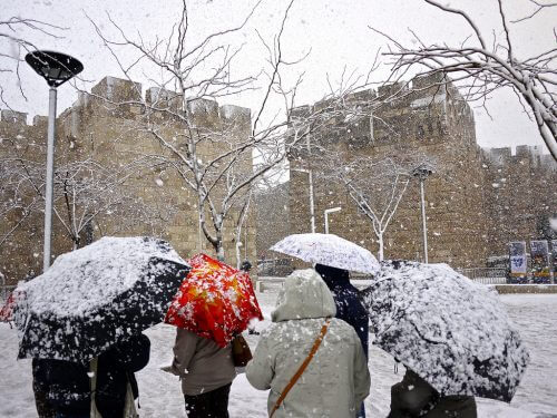
The winter of 2012 was one of the coldest that Europe has known. The cold wave, which began at the end of January, brought with it low temperatures of up to minus 42 degrees in Finland, and snow that covered large parts of the continent, including southern France and even North Africa. But along with the spectacular and rare sights, the snow also caused serious damage to the soul. More than 800 people died across Europe as a result of the extreme temperature.
A slight jump back, to the summer of 2003, reminds us that even extreme heat events can be deadly. That summer brought with it the heaviest heat wave that Europe and the region had known in 500 years. For eight consecutive days, a temperature of more than 40 degrees was measured in northern France, and in a country not prepared for such severe heat, the results were fatal: approximately 15,000 people died as a result of the severe heat wave, most of them elderly who suffered from dehydration, many of them in homes where there was no air conditioning air.
Air temperatures, therefore, have a major impact on public health. Higher or lower than average temperatures can cause illness and even death. This is especially significant within the cities - the place of residence of more than half of the world's population.
Now, A new Israeli study Suggests the use of satellite images to measure the temperature change within the city in high resolution. Beyond applications related to public health, the new model developed by the researchers can give tools to urban planners to deal with particularly hot areas within the city.
Small changes, big impact
What is the relationship between temperature and health? International research which examined over 74 million deaths in 13 countries over a 27-year period, found that 7.7 percent of the cases were due to suboptimal temperature exposure. Cold is the main cause of death, 200 times more than heat. The study also showed that while only a small portion of the deaths were due to extreme temperatures, in most cases the cause is temperatures that slightly exceed the optimal temperature.
"We need to separate an increase in the average temperature from cases of extreme temperature," says Dr. Hagai Levin, head of the health and environment track at the Hadassah School of Public Health - The Hebrew University. While extreme temperatures have an immediate effect on health, and can cause death in vulnerable populations, a not particularly large increase in the average temperature imposes an additional burden on health, which sometimes manifests itself in morbidity and mortality in the long term. "Studies show that an increase in the average temperature causes excess mortality, where the populations at risk are the elderly and infants and patients with chronic diseases. Exposure to high temperature during pregnancy, for example, increases the risk of premature births and low birth weight," explains Levin.
In this sense, air temperature is similar to air pollution, explains Levin. "We are exposed to temperature all the time, so even if the changes are small, when you multiply them in the population as a whole, then the effect is very large." Research on how temperature change affects public health is in its infancy, and the warming has not yet reached its peak either, therefore, Levin emphasizes, we must take steps today and prepare for the new situation.
Two temperatures in the same neighborhood
When we listen to the weather forecast on the radio or watch it on TV, we get temperature data about regions or cities. But the heat levels also vary significantly within the city itself, as does the health risk caused by exposure to a temperature that is not optimal. The problem is that measuring the temperature with high resolution inside the city is not possible with the tools offered by the individual meteorological stations scattered throughout the urban area. The use of satellite images, which capture the energy fluxes emitted from the surface, allows a reduction to a much better resolution.
Researchers from Tel Aviv University combined data from satellites and meteorological measuring stations to better understand how land use affects air temperature. The research was conducted as part of Ran Plata's master's thesis under the guidance of Dr. Alexandra Chodnovsky, head of the Air Quality Laboratory from the Department of Geography and the Human Environment. The researchers used remote sensing methods based on the analysis of satellite images. "We looked at the radiation that objects such as roofs, residential buildings, roads or wooded areas emitted. The hotter the body, the higher the radiation it emits, and we adjusted it to air temperature values using a statistical model. We compared the results of the model to meteorological measuring stations and measurements from other satellites," explains Chodnovsky.
The research findings show a significant variation of the temperature within the city. In areas with dense vegetation, the air temperature was found to be half a degree lower than in built-up areas. The open areas, especially those with little and low vegetation and no irrigation or landscaping, were found to be among the hottest areas. For example, the researchers show that in an area that used to be a park and became open land, the temperature rose significantly - up to 4 degrees. On the other hand, the lowest temperature was measured over bodies of water (such as Nahal Yarakon) - up to three degrees less than that measured in built-up areas.

Tel Aviv is heating up
The researchers also created maps that show high-resolution temperature variation within the city over three periods over the past 30 years. Between 1984 and 2015, in the summer months (July-August), the air temperature in the center of Tel Aviv and in the centers of the nearby cities in Gush Dan rose moderately by 0.3-1 degrees, as did nearly 57 percent of the total area in Gush Dan. In another 13 percent of the area there was a more significant increase of between 1 and 1.5 degrees.
These data correspond to the trend of the average temperature increase in Israel. in the report "Climate changes in Israel" Published a year ago by the meteorological service, the average annual temperature in Israel in the last 600 years was examined. The report found that starting in the XNUMXs there was a marked increase in the average annual temperature. It was also found that "the main contribution to the increase in the average temperature is the increase in the minimum temperature. This is especially evident from the mid-nineties in the summer months - June, July, August."
Part of the warming of cities stems from the global trend of air temperature warming as part of climate change - which according to A recently published report constitutes the greatest threat to global health in the 211th century. Another part stems from changes that have occurred in the urban landscape, such as the disappearance of vegetation and its replacement by asphalt, a phenomenon known as the "urban heat island" - where the temperature inside the city is higher than areas outside the city. The phenomenon intensifies due to the heat emitted from electrical devices such as air conditioners and vehicles and insufficient air circulation resulting from blocking the wind by buildings.
Back to the study - compared to the areas of the city where warming was found, 16 percent of the areas examined maintained the same temperature, and in three percent of the area, surprisingly, cooling actually occurred. In a clear state of warming, what could be the cause of that local cooling? The researchers explain that the cooling is due to the change in the use of the land - for example, areas that were previously exposed to the direct sun and near which a high-rise building was built receive less of the direct sunlight, so on average they are colder. The same goes for areas that were defined as bare ground and were filled with vegetation over the years - cooling was recorded in these areas.
The forecast: cold in the Ayalon lanes
"In epidemiological studies, we want to know the extent of a person's exposure to a suboptimal temperature. If a person lived in a warmer area of the city - something that can be learned from the satellite images - this means that he was exposed to higher temperatures," explains Chodnovsky. Combining the research findings with public health data, for example those that show the number of deaths and morbidity in the city, could in the future indicate a connection between warmer areas and disease and mortality.
Another possible application of the research is in more correct urban planning, says Chodnovsky. As an example, she cites the plan to roof the Ayalon lanes and the intention to build a park over them. "Our research showed that above and around roads are the highest temperatures, about 3-4 degrees higher than green areas." Programs that can turn a road back into a green area (without eliminating the road), such as roofing the Ayalon lanes, offer the best improvement in terms of mitigating the rise in temperatures. "With the help of the tools provided by the new model, we can come to the planner and tell him where the temperature has risen and where to put the emphasis, and use the model to predict how the change will affect the temperature," concludes Chodnovsky.
