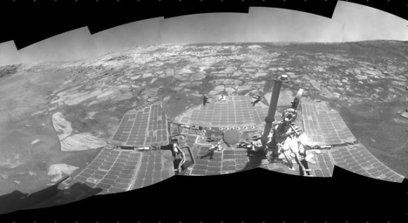
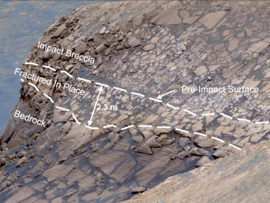
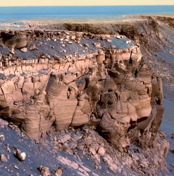
Opportunity left the Victoria Crater eight months ago, but a concentrated analysis of all the findings it sent from there allowed scientists to conduct a comprehensive and integrated review of the crater area, and it turns out that some of the features can only be explained by the presence of water in the past

A large team of researchers was able to simultaneously analyze a large data set transmitted by the Opportunity rover residing in the Victoria Crater on Mars. These data testify to the vehicle's success in maintaining a state of activity with a remarkable and fortunate lifespan, and they also allow us to paint a picture of climatic events that shaped the Victoria Crater, as seen in the NASA and Caltech MAZB image.
The climatic history is extensive and comprehensive, including flash floods and winds that shaped the surface, over billions of years. The data were published in the journal Science. Due to the vehicle's ability to move from place to place and thanks to its long life, the mission scientists were able to explore Mars in depth in a way that they could not have expected before.
"There was no way for Spirit and Opportunity to make all these discoveries if their lives had not been so long." said the lead researcher on the project, Steve Squires of Cornell University in Ithaca, New York, who signed the paper along with 33 other researchers. "Mars has been better to us than anything else. I believe that their longevity indicates the excellence of the work done by the team that built them many years ago."

The Opportunity vehicle was able to study the details of three different craters located over a distance of about five kilometers. Data and images taken by the robotic vehicle showed similar patterns of sedimentary rocks in each of the craters, patterns that may have been formed by water flow in ancient times. According to Squires and his team, this discovery means that water once covered the entire area and helped shape this part of the planet a long time ago.
Opportunity also revealed that the water came and went again and again billions of years ago, the wind worked much longer and concentrated the sand in the dunes between the ancient water periods. These activities still shape the landscape today. In the Victoria Crater, sharp cliffs and moderate alcoves alternate each other around the edge of the bowl, which is about 0.8 km in diameter. These and other features indicate that the crater was once much smaller than its current size, but the play of the wind gradually expanded it.
"What attracted us to Victoria Crater was the outer layers of the rocks exposed there." Squires said. "The impacts from space that hit the crater millions of years ago provide a golden opportunity and vehicle capability to allow us to enjoy the advantage of exposure to these sediments."
By photographing the rim of the crater and inside it with a variety of instruments, the mission scientists were able to observe layers in the rocks around the crater, including layers over 10 meters thick. These noticeable patterns indicate that the rocks were formed as a result of moving dunes that later hardened and became sandstone.
Inside the Duck Bay, the vehicle discovered that the lower layers contain less sulfur and iron and more aluminum and tin (silicon). This composition corresponds to the patterns discovered by Opportunity earlier in the smaller Endurance crater, which is about 6 km from the Victoria crater, which indicates that the processes that change the environmental conditions recorded in the rocks were regional and not just local.
Squires said there are specific minerals and specific geochemical patterns in the crater walls. In all three craters - Eagle, Endurance and Victoria, structures rich in iron and sulfur that scientists call "blueberries" were found embedded in the rock. The scientists came to the conclusion that these were formed as a result of the deposition of minerals due to the seepage of aqueous solutions into the rock.
Opportunity gained over 30 meters of height when he traveled from Endurance Crater to Victoria and the amount of "blueberries" increased with height. However, after the vehicle entered the Victoria crater, which is 75 meters deep and 750 meters in diameter, the sulfur compounds appeared again in the ground. The amount of sulfur in the rocks in the depth of the crater is greater than in the upper layers, which indicates the activity of groundwater at a greater depth in the past.

Opportunity also observed for the first time the interactions between volcanic rocks and the acidic water that together formed sulfur salts. Dry sands rich in these salts joined the dunes. Due to the influence of the water, these dunes hardened and became sandstones as well. Later additional covering by water created the iron-rich sulphide deposits, changes in the minerals and pores at different angles formed as the crystals melted and drifted apart.
A rock from space created a hole with a diameter of about 600 meters and a depth of 125 meters. The wind erosion bit into the walls of the crater and partially filled it, and thus the diameter of the crater increased by 25% and its depth decreased by about 40%.
Since leaving Victoria Crater about eight months ago, Opportunity has been on its way to Endeavor Crater, which is 20 times larger than Victoria Crater. The vehicle meanwhile moves about a fifth of the distance which will total 16 kilometers when it reaches its destination.

9 תגובות
Discovered water who believes
To Itzik, there is no smell there, because a person will lose consciousness long before his mind analyzes the local aromas. (But you'll have time to feel the terrible burning in your mucous membranes before the black screen goes down)
Tomer
The route is generally planned according to satellite maps and photos from the terrain of the vehicles.
The vehicles themselves have a basic navigation ability, the main thing of which is to continue driving if the slope is not too steep and especially to stop in any other case.
Then the environment must be photographed and sent to Earth to analyze the images to load an alternative route. Each call is about 5 minutes each way.
Also, in the winter, the level of activity of the solar cells in the car decreases and there is a stage where the car goes into standby mode until the summer.
And one of the vehicles also has a stuck wheel, but I don't know if it's one or the other.
Why does it take a vehicle so long (8 months) to go only one fifth of the way to Endeavor Crater...?
If I'm not mistaken, according to what was written in the news, this means that the vehicle only travels 13.33 meters per day...
There's a smell in there, but with bone-chilling temperatures and deadly radiation, I wouldn't stick my nose out of a space suit if I were you (;
I wonder what the smell is in the air
I think it smells like a liquid car battery, (sulfur and acids)
And for all those who will say that there can't be a smell, yes there is a smell there because there is an atmosphere
Thank you. We can use the minerals that are on Mars to create the future colonies.
It should be "Zoran" (silicon), Khmeran is aluminum
Thank you. Of course there should be a cluster instead of a cluster