GMES is an innovative European enterprise that uses satellites, aerial, marine and ground sensors for the benefit of the environment, security and management of the Earth's resources. Sentinels in space

Amber dew Galileo Magazine
Space serves as an extensive platform for human activities. Beyond the activity of manned flights to the International Space Station and satellites for security and communication purposes, many satellites operate in space to monitor the Earth for the purposes of monitoring the quality of the environment and improving our understanding of the various processes that affect us all - including the depletion of the ozone layer, an increase in the amount of carbon dioxide in the atmosphere, the melting of glaciers, and more.
The European Union established a new initiative designed to give Europe independence in the field of remote sensing using satellites, air, sea and ground sensors for various purposes, including security, environmental protection, monitoring of natural resources and natural disaster monitoring. This project, which is less known to the public, is called GMES - the acronym for Global Monitoring for Environment and Security, and it is partnered by the European Commission and the European Space Agency. Recently the name was changed to a more catchy name, "Copernicus", but for various reasons the Europeans returned to the original name GMES.
Here we will describe the project and examine its spatial aspect, which is integrated with other areas of activity, in order to create a first synergistic system of its kind in terms of its goals and the scope of its activity. The information obtained from the sensors of the GMES project will help researchers to better understand the nature of environmental changes on Earth.
According to expectations, the project will enable optimal planning of roads and roads, will help city planners, will help make decisions in the field of agricultural planning and energy resource management, including renewable energy. For the benefit of the matter, various European countries partner in the project with the contribution of resources, technologies and scientists.
The space component of GMES
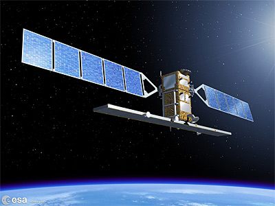
Due to the ability of low-orbit satellites to cover the Earth's surface efficiently and quickly, the reliance of a global monitoring enterprise on a satellite basis is understandable. The European Space Agency is planning an array of five satellites that will serve the GMES project, called Sentinel.
The array of "space sentinels" will include satellites of several types, to carry out different purposes as part of the earth monitoring mission:
- Sentinel 1: a satellite equipped with a SAR radar system. The satellite will be launched into a polar orbit (where the satellite passes over both poles, the north and the south) around the Earth towards the end of 2011.
- Sentinel 2: a remote sensing satellite in the optical, multispectral field, which will be used to build a database with global coverage. Its launch is expected in 2012.
- Sentinel 3: a satellite whose main purpose is the study of the Earth's marine environment; Its launch is expected in 2012.
- Sentinel 4 and Sentinel 5: satellites for monitoring the atmosphere, which will monitor, among other things, the levels of greenhouse gases. The probes will be integrated with satellites for meteorological research, one of which is not of the Sentinel series, and is expected to be launched into space in 2017, 2020 and 2024. A technological demonstrator of the Hemated may take off into space in 2014.
It is interesting to note that the Israeli-French satellite Venus (developed according to an agreement between the Israeli Space Agency and the French space agency CNES, and built in the space-based factory of the Aerospace Industry with a multispectral camera made by Al-Op), can be integrated into the GMES project and be a pioneer in terms of its capabilities; Israeli partnership in the project is being examined at various levels, but at this stage it is still too early to determine whether Israeli satellites will be part of its satellite fleet.
The raw data from Sentinel satellites will be transmitted through a network of European ground stations, decoded, digitized and provided to users of GMES services. The overarching goal is to produce products that are "made to measure" for each of GMES's consumers. In many cases, the data that will be transmitted from space will be combined with data that will be obtained using aircraft (including unmanned ones), marine and terrestrial sensors. For example, information about air pollution coming from a sensing satellite equipped with a multi (and in the future hyper) spectral camera, will be combined with data from a network of sensors for monitoring air pollution on the ground, for the purpose of producing an air pollution forecast for several days.
The security component of GMES
Naturally, the European publications, which expand a lot on the subject of earth monitoring technologies for the needs of environmental quality and crisis and natural disaster management, greatly underestimate the security component of the GMES project.
The GMES project intends to collect data on air quality in Europe, and provide micro-forecasts - in location and time, to warn against contamination and deterioration of air quality
However, based on an examination of the project's various websites (and see the "for further reading" box) and documents from the European Commission, it is possible to note several security aspects of the project, including: First, maritime surveillance, which includes monitoring and maintaining Europe's maritime borders and Other navies of interest to Europe, as well as tracking illegal immigrants and illegal use of the sea for the purpose of smuggling goods and other types of unauthorized activity.
Second, surveillance of essential ground infrastructures (such as power plants, fuel depots, train stations, etc.), including maintaining land borders and monitoring vehicles, smuggling and border crossing. Third, assistance to peacekeeping missions, which includes surveillance for conflict prevention, management of humanitarian crises arising from these conflicts and population monitoring.

Response to emergencies
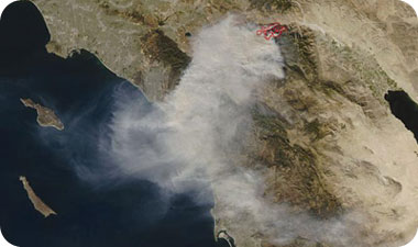
According to the initiators of GMES and its planners, it will be possible to use the project to manage various crises and emergency situations on the planet. Situations such as floods, forest fires, earthquakes, major pollution in the air, sea and land - all of them will be able to be monitored as they occur using Sentinel satellites and the other sensor arrays of the GMES project.
The various products of all the means of sensing and collection will be merged into a whole of up-to-date information, which will be available to managers of the crisis and emergency situations and will help them to make the necessary decisions efficiently and quickly; The inclusion of the European navigation system "Galileo" in the GMES project will further strengthen its capabilities and the quality of its products.
As part of the European infrastructure for assessments in emergency situations, Sentinel satellites are designed to collect (and then analyze) infrastructural information about areas exposed to various dangers, including multi-layered urban information, about the transport infrastructure, residential density, the dangers of exposure to man-made contamination (for example during a factory fire various chemicals) etc. This information will serve as a basis for future urban and environmental planning in Europe on the one hand, and will serve as a starting point for monitoring changes as they occur, on the other hand.
Atmosphere monitoring
Monitoring air quality and providing forecasts for cases of pollution (natural or artificial) is an important element of public health. The GMES project intends to collect data on air quality in Europe, and provide micro-forecasts - in location and time, in order to warn against contamination and deterioration of air quality.
In addition to ground and airborne sensors, some of the project's satellites will also be used for this mission. Through research and a better understanding of the carbon and methane cycle, the information from GMES sensors will be used to understand the processes at the global level, not only those of interest to Europeans; The information will be transmitted in real time to GMES users, and at the same time will be saved for future research purposes.
The European Space Agency is in negotiations with NASA regarding the mutual sharing of data from the existing and planned US satellites for Earth exploration, thereby further enhancing the capabilities of the GMES project itself. Part of the monitoring of what is happening in the atmosphere will deal with the interaction between ultraviolet radiation and the upper atmosphere, including the ozone layer.
The GMES project is the first attempt to harness an entire continent for a joint scientific and technological effort, the main concern of which is the quality of life of European residents; This is also the first attempt to create a massive array of information fusion and its targeted distribution to consumers, in real time. One of the main challenges of the project is the ability to "divert the chaff from the chaff", that is, extract the interesting data from all the data, when necessary and for those who need it. The project is in the initial stages of the deployment of the systems included in it, and it will be possible to learn from the way it is conducted also about the management of international projects, from which economic and technological gains are expected in addition to an improvement in the environmental scientific information that will be produced from them.
The author is the head of the Center for Space Research, the Fisher Institute for Strategic Air and Space Research, and the chairman of the Israel Space Association.
The article was published in Issue 127 of the Galileo journal

One response
How can a satellite detect smuggling? I think this is an exaggeration.