It is a continent with an area of 14 million square kilometers and a population of 4000 people - who are engaged in research and return to their universities afterwards
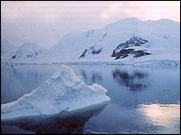
Antarctica, the kingdom of the ice, is a land where few people live. It is a continent with an area of 14 million square kilometers and a population of 4000 people. Those who live there are research teams who come to it for fixed periods to carry out various studies and at the end of their assignment there, return to the parent universities and continue their research under much more favorable conditions. The continent's name comes from the Greek word Antarcticus which means the opposite of Arctic. Endless ice, freezing cold and no living soul. No conceivable form of human life is possible on this continent. The hidden is more than the revealed in everything related to this terrible block of ice and the intellectual challenge is very great. When was the continent formed, when was it covered with ice, will there be life on it and what is actually happening there? A collection of puzzles that are still far from being solved, but presenting even some of them can raise no less intriguing questions.
The accumulated geological findings led the researchers to the conclusion that 170 million years ago Antarctica was part of the Gondwana supercontinent and over the years this continent broke up. And here are recent satellite observations that revealed that at a depth of 800 meters under the ice in Wilkins Land in East Antarctica, a huge crater with a diameter of 480 km is buried (the largest crater on Earth found so far). It is believed to have been formed by a meteorite impact in this area 250 million years ago. In terms of its effects on the Earth, the results of its impact were greater than those of the meteorite that created the Yucatan Crater (the famous crater that, according to today's accepted estimates, led to the destruction of the dinosaurs). It was this impact that led to the disintegration of the supercontinent and pushed the part known today as Australia northward. According to the accepted approach, Africa separated from Antarctica 160 million years ago and India separated from it 125 million years ago. 65 million years ago Antarctica, which was still connected to Australia, enjoyed a tropical to subtropical climate. A clue to the climate in the past is the finding of two dinosaur skeletons at two research sites far from each other. 40 million years ago Australia-New Guinea separated from Antarctica and then the ice appeared for the first time. The ice slowly began to spread and took the place of the forests. From 15 million years ago until today, the continent is covered with ice. In light of the discovery of the giant crater, it will be necessary to reconcile the new data with the accepted hypotheses. This will have effects on geological knowledge, in particular in everything related to the migration of the continents and large-scale climatic changes that have occurred on Earth.
Has Antarctica been permanently covered in ice since then? Perhaps there were partial or complete and cyclical thaws that resulted in the exposure of parts of the continent? What raises these questions is a map of the world drawn by an admiral of the Turkish fleet named Piri Reis in 1513 that also includes Antarctica. The admiral's comments on the deer skin on which the map was drawn show that it was based on ancient maps from the fourth century BC and even earlier. The part of Antarctica shown on the map is the northern coast of the continent. What is amazing about this map is that the coastline drawn is the one that is under the ice. Logic says that such a map could have been drawn when the coastline was free of ice, and this contradicts the estimate that the entire continent was covered by ice until 15 million years ago. Recent studies based on ice samples of the continent taken from different depths through drilling show that the last time the continent was free of ice was before 6000 years. There are those who dispute this conclusion and place the limits of thawing at the period of 9000-13,000 BC. Even if this estimate is correct, we have an order of magnitude regarding the last period when the continent was warmer. Around this time 6000-9000 years ago the Sahara was a bustling area and 6000 years ago the climate began to change and the entire area became the desert we know today. Due to the proximity between the orders of magnitude of the periods and with careful consideration of these hypotheses, the impression obtained is that the Sahara and Antarctica each underwent an acute climatic change more or less at the same time. Did the entire earth undergo severe climatic changes on a global scale at the same time? The intriguing question is who drew the original maps? What is clear is that those who reached the end of the world had the technological and logistical ability to make such a long journey possible. Another conclusion is required from this, and that is that written history began long before Shumer.
When talking about rivers, you can imagine their flow in many places on earth, including deserts that were once areas with a favorable climate and abundant with life. And now satellite photos have revealed that there are also rivers in Antarctica. Water does not flow in them, so what does flow in them? It turned out that this continent was alive and active a tangled network of ice flowing into the center of East Antarctica. Some of the ice streams are extremely long - 800 km. This is not a torrential flow of ice, but May? The ice in these directions moves at a high speed relative to its surroundings - 900 meters per year. These rivers are estimated to have existed for 6000 years. Does this have anything to do with the climate change we referred to earlier? Dunes are another well-known phenomenon, also found on this continent. These are not sand dunes, but accumulations of ice to form dunes that can reach a height of 8 meters and a length of 6 km. These dunes have a glassy appearance on the one hand and wavy formations on the other. These dunes are formed on mountain slopes and their speed varies between 80-360 km/h. It would be appropriate to carry out comparative studies with the dunes found at the north pole of Mars and with the recently discovered dunes on Saturn's moon Titan.
The biggest and strangest surprise is the invention of flowing water lakes. Today it is known about the existence of 145 lakes concentrated in Saber. They are all at different depths below the ice layer and of different sizes. The largest of them has an area of 8640 square kilometers, the second largest has an area of 1232 square kilometers and the third has an area of 992 square kilometers. All the rivers are connected by a network of flowing rivers. The large lake, Lake Vostok, is 3.6 square kilometers below the Russian research base Vostok, hence its name. Of all the lakes found so far, the information about it is the most since it has been the focus of research since its discovery. In fact, hints of its existence appeared when the American Nimbus 5 satellite launched in 1973 pointed its instruments towards Antarctica and to everyone's astonishment a site with water was discovered. No one at that time knew that it was a lake, and the explanations given to explain the phenomenon did not prove themselves either. Only 12 years ago, Russian scientists showed with certainty that it was a lake.
The mapping of the lake using an airborne radar device showed that it is made of two basins separated by a high underwater ridge. The length of the lake is 250 km, its width is 40 km and its depth varies from place to place. The water depth in the northern basin, the smaller of the two, is 430 meters, at the ridge line separating the basins the water depth is 214 meters and the water depth in the southern basin is 860 meters. It is currently estimated that the basins were formed 15-20 million years ago during tectonic activity that raised the surface of the land, long before the continent was covered by the ice sheet. Later when the ice reached the bottom of the basins it was probably heated by radioactive activity coming from the Earth's interior. The ice melted and turned into liquid water that filled the two basins to form a lake. Is this process responsible for the creation of the other lakes?
A very strange find related to the lake was discovered in early 2001. Magnetic, electrical and solar measurements under the ice along the eastern shoreline of the lake revealed a strong gravimetric anomaly. One of the explanations given for this phenomenon is that the Earth's crust near the lake is very thin. It was his tension that led to the development of this anomaly. Some have ruled out this explanation by saying that the narrowing of the depth of the crust will result in the heating of the rock in place and weaken the ability of the crust to increase the strength of the magnetic field. In fact, no satisfactory explanation has been given for this phenomenon to date.
The question of the questions regarding these lakes is the possibility of the existence of life in such a hostile environment and this is of great importance in terms of astronomical research. The existence of life here raises the likelihood of finding life on Mars and in the underground oceans in Europa, a moon of Jupiter. The accumulated evidence during the research done on this continent is more than encouraging. In two drillings done above Lake Vostok in 1999, which reached up to a height of 120 meters above the water surface of the lake, bacteria were found and that the chances of finding bacteria and/or other types of life in the lake itself are increasing.
Another lake, Lake Vida (more than 5 km long), from the ice sheet above which ice samples were taken and microbes 2800 years old and more were found in them. Another lake where biologically significant tests were done is Hoar Lake. Drilling into it was easy since it is near the surface. Its water level is between 3-6 meters above the surface. An abundance of microbial life is found here, some of which are species that were not known until now. A large part of them is found on the lake floor. Surprisingly, evidence of photosynthetic activity was also found, even though the amount of light reaching it is almost zero. This finding is of great importance regarding deeper places in the seas and oceans since the chances of finding photosynthetic activity there also increase and this brings us back again to the question of the existence of life on Mars and Europe.
Another biological surprise was revealed when in 2002 a huge block of ice broke off from the continental shelf and at a depth of 800 meters below sea level a rich and diverse ecosystem such as bacteria and oysters was exposed. Sunlight does not reach this depth and the source of energy is methane.
The uniqueness of Antarctica and the surprises that still lie in it can not only illuminate and renew various aspects of the Earth's geology, it can also be used as a key that opens a door to other worlds far away from our world.
Selected sites
"Giant crater found: Tied to worst mass extinction ever"
"Ice shelf collapse reveals new under sea world"
"Strange artifact"
"Stunning new map of Antarctica"
