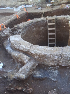
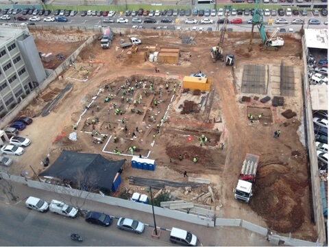
During archeological salvage excavations recently conducted by the Antiquities Authority on Barzel St. in Ramat Ha'il before the construction of the Physicians' House on the site by the Sufrin Group, an ancient well was uncovered that was used in the Byzantine and early Islamic periods.

During archeological salvage excavations recently conducted by the Antiquities Authority on Barzel St. in Ramat Ha'il before the establishment of the Physicians' House on the site by the Sufrin Group, an ancient well was uncovered that was used in the Byzantine and early Islamic periods (1,400-1,110 years ago).
According to Eli Hadad, the director of the excavation on behalf of the Antiquities Authority, "the find of the well, of the type known as "Antila"' has now been uncovered for the first time in the Tel Aviv area. The importance of the discovery is that it adds information about the aspect of daily life in the Yarkon area 1,400-1,200 years ago, including agriculture. Pumping systems of this type operated in Israel from the Roman period (2000 years ago) onwards, but few have been studied in depth. We can name among them the systems discovered in Tel Ashdod, in Yavne Yam (today near Kibbutz Palmahim) and in Ramla. Wells were also explored along the coastal plain in Atlit and Acre. Such wells have recently been restored in ancient buildings and Bens Ziona."
The well that was discovered is considered sophisticated. Unlike in simple wells, where a person would draw water from the well on his own with buckets, here the well acted as a pumping facility, a "factory" that provided water for agriculture and human needs. The well is located about 150 meters from the bank of Nahal Yarakon, goes down to the groundwater, which is probably more than 9 meters deep, and consists of a vertical shaft with a diameter of about 3.5 meters, lined with ash stones carved from Kurkar. It is possible that above the mouth of the well there was a superstructure that has not been preserved to this day. In the upper part of the well, around the upper wall, pits were exposed for the placement of wooden beams that held the system for pumping the water, which operated by means of a wooden wheel to which a rope was tied to which special jugs (antyls) or other receptacles were attached for this purpose. This wheel was powered by the power of an animal (donkey, ox or camel) that turned a horizontal wheel (starting from the middle of the 19th century, the place of the animal was replaced by an engine, and this can be seen in the many known wells from the Ottoman period, for example in Jaffa, an area where they were used to irrigate orchards) . The horizontal force was transferred to the vertical wheel through a sophisticated gear system. The clay pots (pottery jugs) were tied to ropes and used to raise water in a "moving ribbon" and pour it through a channel into a reservoir from where it was taken for drinking or irrigation. The remains of such a reservoir (plastered pools) were uncovered in the current excavation at a distance of about 15 m from the mouth of the well.
A significant number of jar fragments were found in the excavation, such as date from the Byzantine period, as well as the early Islamic period.

The reservoir that was uncovered in the excavation had a floor made of stone slabs, and it was divided into two compartments, with a gravel wall between them. Remains of buildings from the Byzantine period were also found near the reservoir, probably related to the complex of the well and the reservoir.
According to the find, it can be said that the well was used during the late Byzantine period (sixth and seventh centuries AD) as well as in part of the early Islamic period (seventh and eighth centuries AD). When it ceased to function and was abandoned, the facility was clogged with sand.
The area of Ramat Hay'il is full of archaeological finds. In other excavations conducted in the past nearby, ancient remains attributed to many periods were uncovered. In the area close to the current excavation, excavations were carried out in the past by Dr. Yaakov Kaplan, who uncovered the remains of a Samaritan settlement known as H. Hadera, which is located about one kilometer east-northeast of the site of Asar Tahanah (near Ayalon Mall near Nahal Yarakon). Also, a magnificent burial structure, from the end of the 2nd century or the beginning of the 3rd century AD, and remains of wine-making pits from the Byzantine period were uncovered.

9 תגובות
http://assaf74.blogspot.co.il/
In the campaign for Sinai and Eretz Yisrael in the First World War, on the Kurkar ridge on which Ramat Hay'il stands today, there was an Ottoman outpost, Khirbat Hadara. The first written instance in which the name of the place was changed to 'Kharvat Hadera' is, apparently, the memorial column to the memory of Yasseh next to Derech Abba Hillel Silver in Ramat Gan. Farmers Sheikh Munis who worked land in the place called it Dera, after the bridge near the Yarkon in Eser Tahanan called, Jisr al-Hadar - the 'Shaun of the Water' bridge, over which the historic Jaffa-Saklem road passed, and for some reason, according to the local researchers' writings, the Jews , it is called, "Hadera". On the British maps, the PEF map for example, the place is called Hadrah, but it cannot be ruled out that H covered the absence of H in their language and not necessarily to allude to H. The post is weak on the Yarkon pass by ten mills, and allowed an observation of the stream to its outlet to the sea. The outpost was part of the western part of the defense layer deployed by the Ottomans at the end of 1917, north of Yarkon, which stretched from west to east, on Tel Rakit - the former intelligence base on the Kurkar ridge above Tel Baruch beach, Tel Kasila Road, Sheikh Munis, Givat Al-Farahim neighborhood, Benaot Afka 1916, Buacha Khirbat Hadara, and Tel Kana, before the Egyptian expeditionary force (20) of the British succeeded in Yarkon and the western sector of the line of the two Ojats was stabilized. This position was captured, on the stormy night between December 21 and December 1917, 155, by the 52th Brigade of the British XNUMXnd Division, after they succeeded in capturing the Yarkon at Tel Jerisha. The memorial column at the intersection of Abba Hillel and Ben-Gurion streets in Ramat Gan commemorates the work of the brigade in Operation Succeed.
How many installations does this well bring and from which Geo's?
To Aryeh Hershkowitz
Next time they will think about this before they try to murder Jews...
So what's going to happen now?
Will they build on top of it?
Israel could be a touristic gem, and attract many visitors because of its cultural and archeological treasures. In my opinion, the Ministry of Permits should set a target of 10 million visitors (similar to the Czech Republic). And not like today a target of 5 million visitors. A national plan for hotel construction, marketing, and cost reduction must be built.
Until 1948 it was the name of the village Alsualma
http://zochrot.org/place/%D7%90%D7%9C%D7%A1%D6%B7%D7%95%D6%B7%D7%90%D7%9C%D6%B4%D7%9E%D6%B8%D7%94
To: NH …
In Nahal Yarakon, and also in other streams in Israel, lived many animals, some of them dangerous, and also mosquitoes that transmitted diseases. Therefore, people preferred to dig wells nearby, so that it would not be dangerous to pump water (and usually pumping the water was the job of the women) In addition, water from a well is always cleaner than water in the stream, especially in the area of the mouth of the stream, and especially at the end of the summer, so the water stood still more than flowed
Why invest in digging a well when there is a solid stream nearby?