Two strong earthquakes within a few hours and the fact that there was no thick layer of soil that reduces the intensity of the earthquakes, in addition to the construction conditions, and the destruction of the infrastructure - especially in Syria. The time of the earthquake at 4:17 in the morning also contributed to the high death toll
Bob Holdsworth, Professor of Structural Geology, Durham University
The earthquakes that struck Turkey and Syria in the early hours of February 6, led to terrible destruction on a scale not seen in Europe and the Middle East for many decades. The number of dead has exceeded 34,000 people (as of 12/2/2023) and will continue to rise in the coming days and weeks. Hundreds of thousands more lost their homes.
There are many reasons why the death and destruction were so terrible. First and foremost, the great power of the two great earthquakes. These earthquakes (magnitude 7.8 and 7.5) each released energy similar to the energy released in the largest atomic bomb test ever conducted during the Cold War - about 50 megatons, in 1961 by the former Soviet Union. And there were two such events in the same area a few hours apart.
To this must be added the sub-tremor clusters (after market) from the major tremors. These tremors are weaker (usually lower than magnitude XNUMX), but they will last for several days, and will gradually decrease in intensity and frequency. They are nevertheless dangerous, as buildings that have already been severely weakened by previous events may collapse and this will make rescue attempts in the area even more difficult.
Another factor is the timing of the first and largest earthquake. It happened at 4:17 am (local time), when most people were asleep in their homes. During an earthquake, the great majority of victims are not caused by the earthquakes themselves, but by the collapse of buildings as a result of them. Many people had very little opportunity to escape their homes in time. This is probably a major factor in the very high number of dead and injured.
But a major geological contribution to the dimensions of the destruction was the relatively shallow depth of the earthquake's center: 18 km in the first magnitude 7.8 event and 10 km in the later magnitude 7.5 tremor.
The center is the point where the soil begins to crack. These are shocks relatively close to the surface. There are two reasons why this leads to a greater degree of destruction:
The first reason is that the shallower an earthquake is, the closer the Earth's surface is to the epicenter. This means that the earthquake is stronger and more destructive. The shock waves have fewer opportunities to dissipate, as happens when earthquakes occur deeper in the Earth and travel through tens of kilometers of rock.
The second reason is that the cracks that create large magnitude -5.5 earthquakes are more likely to reach the surface. This creates - almost instantly - a ground shift when one part of the ground actually moves several meters relative to an adjacent part.
These surface fragments are very harmful. They can lead to the disconnection of major underground and surface infrastructure, including water pipes, power cables, gas pipes and tunnels.
Already today there are reports of damage to pipelines in Turkey following the events of February 6. Also, satellite photographs and ground photographs of roads and railways that have been cut off as well as heavy damage to the buildings crossed by the cracks are revealed. All this occurs in addition to the damage caused by earthquakes - landslides and flooding of low valleys with groundwater.
A three-meter crack in the road caused by the 2023 Turkish earthquake.
A three-meter tear in the Kahramanmaras-Gaziantep highway, near the village of Tabakli in the earthquake area. Hassan Zozbilir / Eskişehir Osmangazi University, courtesy of the author
In a recent blog post, Professor Hassan Zozbilir of the Center for Applied Earthquake Research at Dokoz Eyllol University reported: “As far as I can see, at least three sections have broken. The total length of the surface fragment is greater than 500 km".
Why were there shallow tremors in this area? Some of the largest earthquakes that are known are all earthquakes in the area known as the "Pacific Ring of Fire". These earthquakes are usually generated at a depth of up to 700 km, when the strong and dense oceanic plates plunge into the Earth beneath the surrounding continents. (Therefore, their damage is softened until the earthquake waves reach the ground. It is true that deadly earthquakes also occurred in this area - and in particular the one that caused the tsunami disaster in 2004 and the Fukushima disaster in 2011, but there could have been many more. AB) While in the Turkey area - Syria There is nothing that will soften the power of the earthquakes.
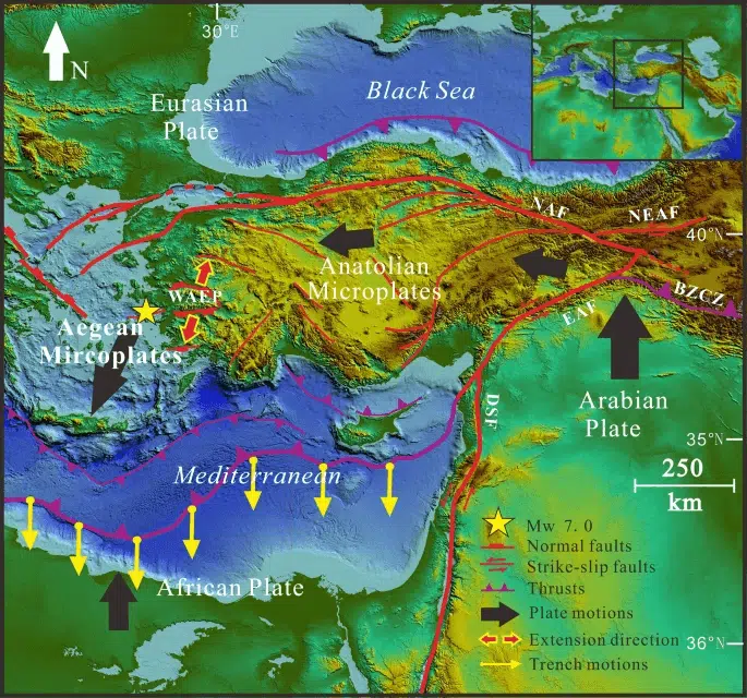
Turkey lies in an area of weaker lithosphere, mainly continental, where the thickness of the crust is only about 30 km, close to the point where three tectonic plates meet - Africa, Arabia and Anatolia. The convergence of the Arabian plate pushes the wedge-like Anatolian plate out to the west, creating a series of sub-vertical (subvertical) strike-slip (replacement fragments) such as the East Anatolian fault, along which the forces acted during the 7.8-magnitude event.
Map showing tectonic plate action near earthquake in Turkey and Syria
In such a continental crust, the strongest part - and the most likely point for the formation of large earthquakes - is usually at a depth between 10 km and 20 km. In such areas, it is more likely that shallow copies will be formed that will tear the surface.
Wrong time, wrong place
A third factor is simply that the area where the earthquakes occurred is highly populated. Given the timing, significant loss of life is almost inevitable following an event - or events - of this magnitude.
Deadly earthquakes are well known in Turkey. In the last 50 years, there have been at least four events that resulted in significant loss of life - in 1975, 1983, 1999 and 2020. Following the 1999 Izmit earthquake, serious efforts were made by the Turkish authorities to improve building standards to better withstand earthquakes.
But there is a limit to what can be done in a highly populated area with events of this magnitude. We must remember that the two main seismic shocks were perhaps more than twice as large as the largest known historical earthquake in this region.
Furthermore, in Syria we must add the fact that years of continuous civil war have significantly damaged the construction infrastructure, making the event in the region less resistant to the effects of seismic tremors. It is likely that this will also harm the efforts to provide aid in the longer term, the rehabilitation efforts.
For the article in THE CONVERSATION
More of the topic in Hayadan:
