Tsunami waves, volcanoes, hurricanes and landslides - all we know about nature's "killers" is that they will strike again and again * Science adds: The article shows that the area north of Delhi that erupted on Saturday morning was calm for 200 years
Popular Sciences
Direct link to this page: https://www.hayadan.org.il/disasterspopsi.html
The article was published for the first time on the Al-Idan website on 13/8/2005 and we are putting it back on the front page due to the severe earthquake that hit northern Pakistan and northern India. On the occasion of the situation, we decided to add some topical comments to the science readers.
The human race is a guest on this loud and boisterous rock called the universe. On December 26, 2004, at 58 minutes and 49 seconds past midnight (GMT), Mother Earth reminded us of this eternal fact. The scariest thing about the latest tsunami is the fact that another performance of the horror spectacle is almost guaranteed. The earth is by nature a prolific architect of riots and a diligent provider of disasters. The only thing left for us to do for our protection is to strive to know where and when the calamities of nature will affect us - because be sure: they will come.
Fortunately, advances in the technologies of remote sensing satellites, computer simulations, radar, seismic monitors, and weather forecasting give scientists an edge, and in many cases allow them to tell us when to flee. Researchers use photo satellites to detect, for example, tiny changes in the deformations of the earth - a 'pimple' that otherwise could not be noticed, may indicate that the replica is about to break or a volcano is about to erupt.
This advanced ingenuity still does not necessarily make the world a safer place. The problem is that humans insist on invading the most turbulent regions of the earth, and continue to build and live in the most dangerous areas. People also mercilessly change or destroy the earth's natural defense mechanisms: uproot vegetation, damage coral reefs and dry up the marshes, thus leaving them much more exposed to the evil effects of storms or tsunamis.
Volcanoes: danger zones: Italy, Indonesia, Central America.
Earth's explosive nature must depend on what lies beneath its surface. Oceans of seething magma beneath the Earth's crust can reach up to 1100 degrees Celsius. The immense heat causes the trend to rise into the crust; If enough trend accumulates near a weak spot, it breaks through to the surface. For hundreds of years, this is exactly how Vesuvius erupted, burying Pompeii and its 3,000 inhabitants under 5 m of boiling ash, and under whose shadow more than two million people live today. Scientists know that Vesuvius is capable of erupting with tremendous force, what they don't know is when.
The most effective tool that helps scientists determine when a volcano is about to erupt is InSAR satellites. Since the early 90s, satellites equipped with INSRs have been launching irregular beams of radar waves towards the Earth. When the waves return, InSAR records their strength and duration. Using InSAR, the scientists can discover slight deformations in the face of the earth, created in the absence of seismic activity.
InSAR is particularly effective for studying volcanoes in remote countries that are not affected by the visits of Western scientists. Although peaks like Vesuvius, Mount Rainier in Washington state and Fuji in Japan get the most attention, there are dozens of other equally deadly volcanoes in Central and South America as well as in Indonesia. Popocatepetl volcano at its 5380 meters, rises above Mexico City, only about 60 km from the city. The "Smoky Mountain" which has erupted 36 times already emits smoke and gas from its mouth almost every month. Atitlan Caldera rises about 120 km from Guatemala City. If an eruption were to occur today, it would most likely cause the death of 90% of the country's residents. For each of these volcanoes, prediction of an eruption using InSAR depends on the surface coverage – rugged or bare ground usually provides better images than snowy or wooded areas. The people of Naples will certainly be happy to know that their neighbor, Vesuvius, is incredibly photogenic.
Hurricanes: danger zones: New Orleans, the Caribbean, Bangladesh
(The article was written long before Hurricane Katrina. AB)
New Orleans, which is already 6 m below sea level, and is sinking at a rate of about 9 millimeters per year is prone to severe flooding and will absorb the most devastating damage from a category 5 hurricane. Since the city is below sea level - with the Mississippi River on one side and Lake Pontcartrain on the other - it is A hydrologic nightmare. The most difficult problem will be storm surge, a phenomenon where strong winds create huge waves along the front of the hurricane. In New Orleans, one big surge is enough to drown the entire city.
Long before settlers looked at the shores of the Mississippi and thought it would be nice to build a house there and raise a family there, the river would occasionally overflow its banks and pile silt and silt on its surroundings. After a particularly nasty flood in 1927, a disaster that claimed 300 victims and left 600,000 people homeless along the river, city officials decided to build embankments - some 7.5 m high - to limit the rising river with the arrival of heavy rains. Residents also found themselves battling yellow fever, a viral disease spread by mosquitoes. From 1817 to 1905, the disease claimed 40,000 victims. People realized that the swamps had to be drained. Now, with the embankments erected and the marshes drained, the city could spread into areas that were previously unfit for habitation. However, when the water is removed from the swamps, the ground begins to sink.
The Sapir-Simpson hurricane rating scale defines a Category 5 storm as having winds of more than 250 km/h and surges of more than 5.5 m. Although hurricanes of this type that land directly on New Orleans are rare and occur once every 500 or 1000 years; However, if such a storm reaches the coast, the resulting wave will fill Lake Pontcartrain, pass over the embankments and flood the city up to a height of 13 meters. In that case, the batteries will be used as the sides of a bathtub, the water will be trapped between the Mississippi batteries and the hurricane protection batteries.
New Orleans is on the verge of completing a $740 million hurricane defense project. As part of the plan, the city is surrounded by batteries to protect its residents from storms up to level 3. Meanwhile, the army is thinking about building a new system of batteries that will be able to withstand the waves of a level 5 hurricane like 'Ivan', which threatened the city last year. To determine exactly where and at what height these batteries should be erected, the engineers enlisted the help of a 5D computer simulation software called ADCIRC, which combines dozens of data such as the seabed and the topography of the coast, wind speed, tidal changes, ocean depth and water temperature - and shows on a map exactly where A terrible surge will flood New Orleans. However, the idea of a battery for a level XNUMX storm is still in its infancy and it may be decades before the new batteries are completed. Until then, New Orleans residents better pray to Helios, the sun god.
Landslides: danger areas: Central America, Central Asia.
(This week, landslides also occurred in northern India a day before the earthquake, in which an Israeli passenger died in a bus that was crushed by large rocks that fell from a mountain. At the same time, Hurricane Stan caused large mudslides in Guatemala AB, 9/10/2005)
Landslide, mudslide, rockslide - by whatever name we call it, the phenomenon is the same: stationary and stable ground afflicted with deadly wanderlust. In most cases, landslides occur when too much water completely absorbs the ground on a steep slope or when an earthquake shakes the ground. It can happen almost anywhere, but Central America - with its steep slopes, frequent heavy rains and unstable volcanic soil - is probably at the top of the list of danger zones.
In 1988, Hurricane Mitch passed over Central America, and heavy rains caused thousands of landslides. Mountains of mud buried thousands of villagers who lived not far from the Casita volcano in Nicaragua after angry rains saturated its slopes and the ground, which could no longer contain them, collapsed. Since then, new "warning maps" for the local officials in Central America mark disaster-prone areas.
For the purpose of mapping, geologists use Aster, which is mounted on board Terra, NASA's remote sensing satellite. Aster can take pictures of the Earth at 14 wavelengths and collect high quality data of 15 square meters per pixel. Closer to the ground, researchers map the risk zones prone to instability using LIDAR. A LIDAR camera - which is usually installed on a patrol plane or helicopter - is similar to a radar, but it works on flashes of light instead of radio waves. If real downpours begin, the equipment goes into emergency mode and sends information every 5 minutes or less. The next time a hurricane whips through Central America, perhaps ranchers and villagers living on the slopes of unstable hills in places like Tegucigalpa, Honduras and Zumpupara, El Salvador - where some of the worst landslides occurred during Hurricane Mitch - will be able to get an early warning that their world is about to end to destroy them once more.
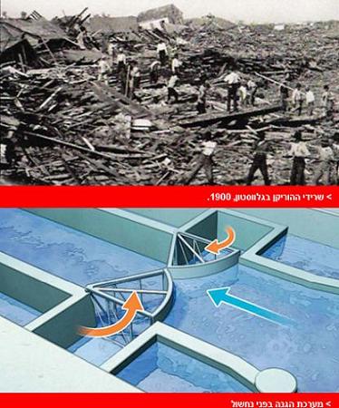
Tsunamis: Danger Zones: West Coast of the United States, Alaska, Japan.
If you ask geologists where the next big tsunami will hit, the same refrain will play again: the northwest coastline of North America. There is the 'Cascadia Trench Subduction Zone', a 1090 km long replica that hugs the coast from Northern California to Vancouver. Like the tectonic impasse that finally broke and caused last December's tsunami disaster in the Indian Ocean, Cascadia is a geological battlefield where the Juan de Fuca plate and the North American plate collide. The subduction pressure created in the first lines can eventually erupt just as it did in Southeast Asia - a seismic event that geologists call: "a large subthrust earthquake", because it takes place between a subducting plate and a rising plate in an area known as a subduction plate.
Earthquakes within an inner plate subduction zone can easily reach 9 on the Richter scale. During such an earthquake, the coastline will sink by one or two meters. The collapse will occur immediately. According to computer models, the tsunami will rise to a height of 20 m or more. Cities like Seaside, Oregon; Crescent City, California; Westport, and Washington, would be washed away in minutes.
Geologists have difficulty predicting exactly when Cascadia will break. Since the replica has been silent for such a long period of time, calculating the noise frequency is not straightforward. Geological signs indicate that large earthquakes have occurred along the Cascadia Trough seven times in the past 3,500 years, and hence scientists speculate that a combination of an earthquake and tsunami occurred every 300 or 500 years or so.
Evidence of a massive tsunami that completely destroyed the Pacific Northwest coastline in the 1700s has recently been discovered. Researchers were able to retrace Japanese evidence from the same year describing a massive tsunami and find within it sediments from the ocean floor buried within continental soil along the coasts of Washington and Oregon.
Most likely, when an earthquake occurs, the first to know about it will be those personnel stationed at the Tsunami Warning Center for the West Coast and Alaska. The center monitors 150 seismic sensors in the countries of the Pacific Rim and 100 measuring devices at sea level scattered throughout the Pacific Ocean. The latest additions to the early warning system are the DART buoys that record the tidal cycles in the Pacific Ocean. However, if there is an abnormality of even 3 cm in the height of the tide - even at a depth of 6 km - the system immediately goes into tsunami emergency mode and sends immediate warnings to the satellites. However, we may find ourselves over-relying on the sophisticated warning systems. In some places, the Cascadia replica reaches less than 160 km from the coast. And so, of course, depending on where the earth will shake along the path, the tsunami will be able to reach the coast in a matter of minutes. DART floats and seismic sensors will activate alarm horns and automatic radio reports in the vicinity of the noise, but the warnings may come too late for the residents.
The highest tsunami wave ever recorded occurred along the coast of Alaska's Glacier Bay National Park in 1958. An earthquake with a magnitude of 8 on the Richter scale in the Prowers replica some distance from the coast knocked down a wall of rock that slid into Utah Bay; The dislodged water and ice created a huge wave that reached a height of 572 m. Number of victims: 2
Earthquakes: danger zones: India, Iran, Turkey
This is all we know: earthquakes occur along geological fault lines - fractures in the earth's crust where the plates are pushed into a kind of geological traffic jam. The difference between a shock and an earthquake greater than 8 on the Richter scale has to do with whether the plates slide under each other when the stress between them is still relatively low or if they break after thousands of years of accumulated stress.
Calculating, in any case, when exactly this might happen, is not an easy task. So it's true, scientists can't tell us when an earthquake will occur, but they are getting better and better at locating the places where the big noises will cause heavy losses and considerable financial damage. The places prone to disasters are cities with many 6-10 story buildings built of reinforced concrete. The final list of candidates stars: Tehran and Istanbul - the two cities have a population of more than 12 million inhabitants and both lie in close proximity to long, deep and powerful seismic replicas. Even more vulnerable is the imprint of the Himalayas in northern India. In the three countries that border it, the combined population reaches more than 25 million people who live mainly in hard and fragile concrete buildings or mud houses.
Much of the transect between Kathmandu and Dehradun, north of Delhi, has not produced any major earthquakes in at least the last two centuries. Sooner or later, this replica will break, and the price it will take will be huge because of the population density in northern India, the soil conditions - which tend to become liquid - and the type of construction.
The best technology, for now, to warn of earthquakes in prone areas is the GSN, a global seismic network based on 135 seismic monitors placed around the world. These record the earthquakes when they occur and the information is transmitted to satellites or uploaded to the Internet. The network, which functions as a seismic watchdog, not only records the noises, but also sorts them. So that eventually the information will be collected into a global database of seismic activity. Analyzing all the data together, it is hoped, may reveal trends and patterns that may herald a break in the copy.
The 'Great Chile Earthquake' of 1960, which measured 9.5 on the Richter scale, is the strongest earthquake ever recorded. A 1600 km replica fault sent seismic waves that reverberated around the world for days and created tsunami waves that reached as far as Hawaii, Japan, the Philippines and the West Coast of the United States.
Number of victims: 2,230

2 תגובות
Ohhhhhhhhhhhhhhhhhhhhhhhhhhhhhhhhhhhhhhhhhhhhhhhhhhhhhhhhhhhhhhhhhhhhhhhhhhhhhhhhhhhhhhhhhhhhhhhhhhhhhhhhhhhh!!!!!!!!!!!!!!!!!!!!!!!!!!!!!!!!!!!!!!!!!!!
Schneitzel
Despite the unfortunate incident, it should be noted that it is a shame to call these natural phenomena "killers" because without them life on earth would not be possible, like volcanoes...
See different sites on the subject and National Geographic!