France will launch a new imaging satellite capable of detecting objects the size of a car
29.1.2002
By: Yuval Dror
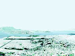
A XNUMXD visualization of the city of San Francisco, based on the SPOT satellite photographs
France will launch into space in about three months the civilian satellite with the most sophisticated photography capabilities in the world. The satellite, known as Spot 5, will be able to locate an object the size of a car from an altitude of about 5 kilometers, with a resolution five times greater than the resolution currently accepted in civilian satellite photographs. The French intend to use the satellite to monitor natural phenomena, forest fires and even traffic jams.
Spot 5 was built by the Astrium company) by special order of the National Center for Space Research in Toulouse (CNES). The satellite was built in cooperation with Belgium and Sweden, which agreed to join the project that started about five years ago. Today its cost is estimated at 300 million euros. CNES intends to launch the satellite into space between April 10 and 16 (depending on weather conditions). The engineers who built the satellite anticipate that it will be active for a period of at least five years.
Civilian communication satellites are launched into space on a regular basis, but photography satellites were until recently the exclusive property of security agencies, who use them for espionage purposes. Experts explain that Spot 5 will be the first civilian satellite to be equipped with photography options similar to military capabilities.
Since the main purpose of the satellite is to take pictures, Spot 5 is equipped with an HGR (High Geometrical Resolution) telescope and two optical cameras. The cameras will shoot at a level of detail (resolution) almost five times higher than the level of detail obtained from the images of Spot 4 (the previous model in the series that is already in space).
In this way, it will be possible to identify objects measuring ten meters in color photography, and objects measuring 2.5 to 5 meters in black-and-white photography. Each such image will capture a relatively small area of 60 square kilometers. The resolution of each image will translate into a file of about 576 megabytes, equal to about 80% of the volume of an average computer CD.
In addition, the satellite will be able to photograph larger areas. For example, it will be able to provide 90D digital simulations of the photographed area. Given the instruction, the satellite will be positioned over the requested site and take one picture. 600 seconds later the satellite will take a second picture. The combination of the two images will provide a stereoscopic image showing an area of about 120 kilometers in length and about XNUMX kilometers in width, at different times and at different angles. These photographs will allow the construction of a XNUMXD image that will help the companies building air fares, bodies mapping new areas as well as communication companies establishing new communication networks.
However, the main purpose of the satellite will be to monitor natural phenomena, the true power of which can only be checked by looking at me: "The new capabilities of the satellite will allow us to monitor forest fires and the way they spread, as well as floods, mudslides and earthquakes," said the project manager, Michael Singer, in an interview with the British BBC network.
Due to the movement of the Earth, Spot 5 will only be able to photograph the same area at intervals of about 4 days. However, Philippe Delclax, the satellite's production manager, said in an interview with the "Le Monde" newspaper that the fact that CNES has four spot satellites in space, makes it possible to take a large number of pictures of a certain area in a short period of time. For example, during the eruption of Mount Athena in Italy last July, the French Space Agency managed to obtain more images than any other space agency in the world.
