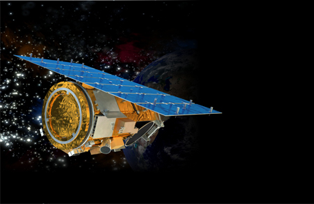
When the GeoEye-1 imaging satellite becomes operational this spring, the advanced optical mechanism will produce more detailed images than any commercial satellite. The satellite will be able to photograph small objects such as home plate on a baseball field and clarify the blurry details in Google Earth
By Bjorn Kerry

This is how the satellite takes pictures from a height of 680 kilometers:
1. Launched into orbit - The GeoEye-1 satellite, which weighs two tons, will be launched to an altitude of 680 kilometers on a Delta 2 rocket from Vanderberg Air Force Base near Lompoc, California. During the planned service life of the satellite - seven years - it will be possible to change the height of the orbit within a range of about one hundred kilometers, in order to maintain a uniform image of the Earth's surface: the resistance of the atmosphere and pressure as a result of solar storms will cause the satellite to gradually approach the Earth.
2. Receives orders - GeoEye's operators can send shooting instructions - what to shoot and when - from one of four ground stations in Alaska, Virginia, Norway and Antarctica. Although the satellite will be used for commercial purposes, all communications will be encrypted under the license terms of the US National Oceanic and Atmospheric Administration.
3. Position Maker - GeoEye-1 is the first non-military satellite to use military-grade GPS units - highly accurate devices that indicate the satellite's exact position in the sky. Two star trackers calibrate the camera's position and angle based on known star coordinates. The combination between these systems indeed allows the location of an object on the ground, within a range of 2.70 meters - a level of accuracy 1.5 times higher than that of previous satellites.
4. Aims the camera - after the satellite is above the target - a block of buildings in New York City or a strip of rain forest, several kilometers in size, in Brazil - the reference wheels begin to rotate and aim the satellite. Nearing the exact point, the wheels begin to rotate backwards to stop the satellite pointing and focus the camera on the target.
5. Checks the lighting - at the ground station, the angles of the sun and the satellite relative to the earth are calculated to determine the duration of the exposure. Since the detection of the satellite - 40 centimeters - depends very much on the exact shape and spacing of the optical mechanism, the mechanism is placed in a sealed tube and kept at a temperature of about 22°C, in order to avoid exposure to the extreme changes in temperature in space. The door opens only when the camera is ready to shoot.
6. Takes the photo - the camera scans the target every two seconds in 20,000 strips of 37,500 pixels on a single pixel, in order to produce an image of 90 billion pixels (in an area of over 15,000 square kilometers) within two minutes. A data processing unit compresses the image files and stores them on a 1 TB flash drive.
7. Transmits it to the ground - every day the satellite can photograph an area the size of Texas. The encrypted images are transmitted to the ground stations 40 times a day, on radio waves. After GeoEye assembles the strips into a complete image, they are sent to clients, which include Google Earth, governments that have (no or almost no) tracking satellites, and the US National Spatial Geography and Intelligence Agency - GeoEye's main client.

zoom lens
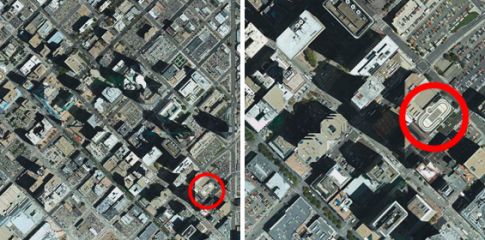
In a satellite image of Denver taken at a standard resolution of one meter [left], the tennis court is barely discernible - but the shape of the court can be clearly seen in the GeoEye-1 image at a resolution of 40 centimeters [right].

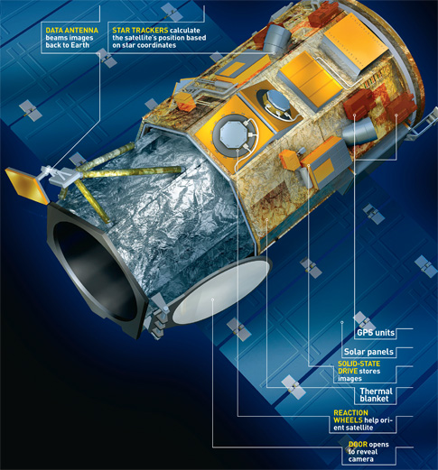
Captions around the chart from top left clockwise
- Antenna for data communication - transmits the images to the ground stations
- Star tracking devices - calculate the satellite's position based on star coordinates
- GPS units
- Solar panels
- Flash memory for storing photos
- Thermal insulation
- Directional wheels - help to direct the satellite
- Door - opens for photography
Length: 4.30 meters, weight: 2 tons, height: 680 kilometers, lap: 98 minutes between the poles, speed: 27,200 km/h; Separation capacity: 40 centimeters; Project cost: 502 million dollars; אתר
Illustrations: Kevin Hand; Photos: GeoEye

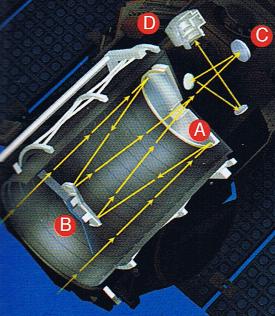
A look at the optical mechanism
The light rays hit the main mirror [A], which is shaped like a cake and is about ninety centimeters in size, are returned to the secondary mirror [B], which is about thirty centimeters in size, and are passed through the central opening to the third mirror [C] which focuses the image and transfers it to the camera [D].
Published in the April 2008 issue of the journal Popular Science.
